 |
|
 |
 |
 |
| Open File Report 00-404 in PDF Format | Clickable Site Map | Data Files on CD |
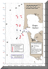
The data contained on these CDs are from the Grays Harbor Wave Refraction Experiment, part of the Southwest Washington Coastal Erosion Study (SWCES). The SWCES is a five-year multidisciplinary investigation of the coastal region between Tillamook Head, Oregon and Point Grenville, Washington cosponsored by the U. S. Geological Survey and the Washington State Department of Ecology. The Grays Harbor Wave Refraction Experiment was a series of measurements made with instruments deployed near the entrance to Grays Harbor, Washington between October 1 and December 30, 1999. The objectives of the measurements are 1) to calibrate and verify numerical models of wave transformation (primarily refraction and shoaling) and 2) to provide information about bottom sediment size, waves, currents, and suspended sediment concentrations for use in calculations of sediment transport. Site locations and deployment times are listed here, and a complete description of the experiment is provided in Open-File Report 00-404, included in Adobe PDF format.
Data are from three types of instruments: SonTek, Inc. acoustic doppler profilers (ADPs), SonTek, Inc. acoustic doppler velocimeters (ADVs), and a Sea-Bird Instruments, Inc. Seaguage wave and tide recorder. (Any use of trade, firm or product names is for descriptive purposes only and does not imply endorsement by the U. S. Government). Various sensors were deployed with each instrument; for more information, refer to the Open-File Report.
The data have been converted to engineering units using software provided by the instrument manufacturers, but no quality assurance checks have been performed. The resulting plain-text (ASCII) files have been compressed and archived in the .zip format, which can be read by software available for Unix, Windows, and Macintosh operating systems. Directory listings for the .zip files are included as plain-text files.
Data are contained on three CDs, as indicated in the following table.
You can navigate to specific files via this table, or by using the interactive
map.
Disk |
Contents |
| CD 01 | Report in PDF format, data from Sites ND and NS in ASCII format |
| CD 02 | Data from Sites MD, MS, SD, and SS in ASCII format |
| CD 03 | ADP and ADV data in binary format (see note) |
(Links to files on the other distribution CDs will not work. Please insert the appropriate CD and try again).
Note regarding
binary files: Raw binary files (.adp files) for the
acoustic doppler profiler data have been included on CD 03. These files
can only be read using custom software, such as SonTek's ViewADP
program. Accompanying plain-text pressure-sensor calibration files (.drk
files) are required to process wave and tide information on the .adp
files. The files
958200.drk and 995410.drk provide pressure-sensor
calibration information for ADP data collected at Sites ND and SD, respectively.
Raw binary files (.adr files) for the acoustic doppler velocimeter
data have also been included. These files can only be read using custom
software, such as SonTek's software gadvhdr and related programs.
For additional information, contact: