Measurement of ridge-spreading movements (Sackungen) at Bald Eagle Mountain, Lake County, Colorado, II: continuation of the 1975-1989 measurements using a Global Positioning System in 1997 and 1999
by D.J. Varnes1, J.A. Coe1, J.W. Godt1, W.Z. Savage1, and J.E. Savage2
Open-File Report 00-205, on-line edition
2000

Trench southeast of station 3, which is on the
rocky hill with 2 standing persons.
View to the southwest.
This report is preliminary and has not been reviewed for conformity with U.S. Geological Survey editorial standards or with the North American Stratigraphic Code. Any use of trade, product, or firm names is for descriptive purposes only and does not imply endorsement by the U.S. Government.
U.S. Department of the Interior
U.S. Geological Survey
1USGS, Denver, CO; 2Colorado School of Mines, Department of Geology and Geological Engineering
Measurement of ridge-spreading movements (Sackungen) at Bald Eagle Mountain, Lake County, Colorado, II: continuation of the 1975-1989 measurements using a Global Positioning System in 1997 and 1999
By
D. J. Varnes, J. A. Coe, J. W. Godt, W. Z. Savage, and J. E. Savage.
ABSTRACT
Measurements of ridge-spreading movements at Bald Eagle Mountain in north-central Colorado were reported in USGS Open-File Report 90-543 for the years 1975-1989. Measurements were renewed in 1997 and 1999 using the Global Positioning System (GPS). Movements are generally away from a ridge-top graben and appear to be concentrated along 3 or 4 trenches with uphill facing scarps that are parallel with slope contours. A point just below the lowest trench has moved the most¾ a total of 8.3 cm horizontally and slightly downward from 1977 to 1999 relative to an assumed stable point on the periphery of the graben. Movements from 1997 to 1999 are less than 1 cm or within the error of measurement.
INTRODUCTION
Geologic and geomorphic studies in many of the mountainous parts of the world during the last 30 years have shown that large mountain masses have undergone spreading movements under their own weight. The movements are inferred to be nearly horizontal near the base and both lateral and vertical near the crest of the mass. These displacements commonly produce linear trenches, upward-facing scarps on the flanks of ridges, and grabens along ridge crests. These features resemble those of recent tectonic faults and indeed spreading movements often make use of any preexisting faults or discontinuities that have an appropriate orientation. In areas where cultural activities require that nearby faults be identified and their recurrence intervals determined, careful studies may be necessary to decide whether scarps and trenches are the result of tectonic activity or gravitational spreading.
Spreading movements are most common in glaciated regions and may have begun when retreat of the ice from valleys left adjacent slopes oversteepened and unsupported. The ground surface offsets are generally one to a few meters at each scarp, rarely some tens of meters, and the movements at most places appear to have been completed long ago. However, in some localities, closed depressions and holes unfilled with soil or vegetation indicate that slow movements may be continuing.
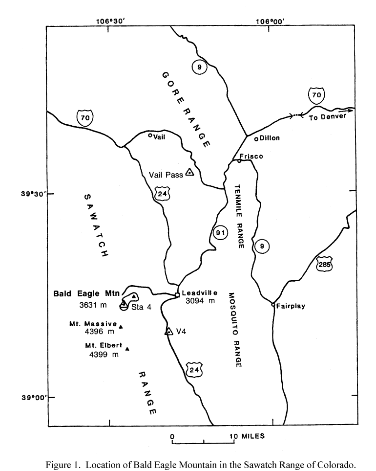
Apparent gravitational spreading has been noted in several geologic settings. Where isolated masses of igneous rock lie on soft shale, as at some laccoliths of central Colorado, the overlying brittle crystalline rocks have broken into slices and spread on the underlying plastic shale. This is the situation at Crested Butte, the locale of a well-known ski resort. However, ridges composed entirely of homogeneous granitic rock also appear to have spread. In all instances that we have observed, the spreading mass of whatever composition is closely divided by well-developed sets of joints. Such is the condition at Bald Eagle Mountain, a broad ridge of gneissic Precambrian granite extending northeastward from Mount Massive, one of the high peaks of the Sawatch Range of west-central Colorado (fig. 1).
Figure 1.-- Location of Bald Eagle Mountain in the Sawatch Range of Colorado.
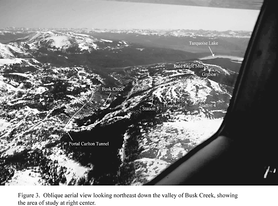
The Bald Eagle Mountain study area is one of moderate relief between elevations 3200 and 3660 m (10,500 to 12,000 ft) (See fig. 2). Access to the foot of the slope is by hard-surface road westward from the city of Leadville, past Turquoise Lake, and thence by a gravel road up Busk Creek to the portal of the Carlton Tunnel, a trans-Continental Divide water diversion project (See fig. 3). The unimproved road continues north and westward over Hagerman Pass at the Continental Divide and on to the town of Basalt. Access on foot toward the trenches east of Busk Creek is by a Forest Service trail that begins at the parking lot near the east portal of the Carlton Tunnel and zigzags up the slope to the southeast.
Figure 2.-- Survey net at Bald Eagle Mountain and valley of Busk Creek, Lake County, Colorado. Base map is from the Homestake Reservoir, 1970, and Mount Massive, 1967, 1:24,000 topographic sheets, U.S. Geological Survey.
Geologic study of the gravitational spreading features at Bald Eagle Mountain and several nearby ridges began in 1975. The relation of these features to local topography and geologic structures here and elsewhere in the western United States has been described by Varnes and others (1989). At the beginning of our study, a few surveyed points were placed to determine if any movements were occurring. In succeeding years, more points were added to create a survey net, which is shown in figure 2, and measurements of the net were discussed in Open File Report OF 90-543 (Varnes and others, 1990). As in all previous surveys, station 4 was assumed to be stable and, in a local coordinate system, to have coordinates 10,000 m N, 10,000 m E, and altitude 3645.415 m (from estimate of 11,960 feet on the topographic sheet). The azimuth of line 4-6 was assumed to be constant at 155.93634 degrees. During surveys in all years, slope distances were converted to horizontal distances at the elevation of station 2, and coordinate positions were determined at that elevation.
Figure 3.-- Oblique aerial view looking northeast down the valley of Busk Creek, Showing the area of study at right center.
The surveys made in 1975, 1977, 1982, and 1984 were made with helicopter support to transport heavy electronic distance measuring (EDM) equipment. When the area under survey became included within the Hunter-Fryingpan and Mount Massive Wildernesses, access by helicopter was prohibited. So, in 1989 only tripods, targets, and a 1-second theodolite were carried up to the site to measure horizontal and vertical angles but not distances. Computation of coordinates in 1989 therefore required that one distance and one direction in the net be assumed unchanged since 1984. For this purpose, not only the azimuth of the line between stations 4 and 6 but also the distance between stations 6 and K were assumed to remain unchanged from their 1984 values. The results of recalculating the network were not entirely satisfactory; moreover GPS measurements in 1997 indicated that the distance between stations 6 and K could not be assumed constant. Therefore, 1989 positions are not accepted and reported in the present paper.
CONVERSION TO THE GLOBAL POSITIONING SYSTEM
In August 1997, the previously surveyed stations were again occupied and their positions redetermined with a portable but precise Global Positioning System (GPS). The resurvey served to determine if there had been additional movements and allowed comparison of the ease and accuracy of the GPS survey with that of the earlier surveys that used conventional electronic distance measuring (EDM) methods in the triangulation-trilateration net shown in figure 2. The 1997 GPS survey was made with three Ashtech Model Z-12, dual frequency receivers using a rapid-static GPS surveying technique with relative positioning (Van Sickle, 1996). The rapid-static technique consists of using at least one receiver at a known base station and the other(s) on remote stations. The minimum occupation time at each station is about 15 minutes, but is dependent on the distance from the base station to the remote station, as well as the number and positions of observable satellites. When rapid-static techniques are used, and the number and configuration of satellites is optimal, the GPS system of receivers and data reduction software (PNAV software, Ashtech, 1997) is reported by Ashtech to consistently determine relative positions to 5 mm plus 1ppm of the baseline length for latitude and longitude. The GPS position of base station 4 was initially determined by a static GPS survey (one hour simultaneous occupation) of station 4 and two benchmarks with known coordinates provided by the National Geodetic Survey—"Vail Pass" at Vail Pass and "V 4" near Leadville (fig. 1). The position of station 4 was determined by least squares adjustment of the triangle formed by the three points, using Ashtech Prism software.
TRANSFORMATION OF GPS POSITIONS INTO LOCAL COORDINATES
To compare results from earlier surveys with station locations determined in 1997 and 1999 by GPS the data must be reduced to a common coordinate system. GPS locations (Table 1) are primarily given in geodetic latitude and longitude and height above a standard ellipsoid. Secondarily, the Colorado State Plane coordinates (NAD 83) and height above mean sea level (NAVD88) were determined using the "Transform" module of Ashtech Prism software. Additional values given for each base and remote station pair include the horizontal grid distance in the State Plane Coordinate system, its azimuth, the horizontal ground distance at the mean elevation between the base and remote station, and the slope distance between the two.
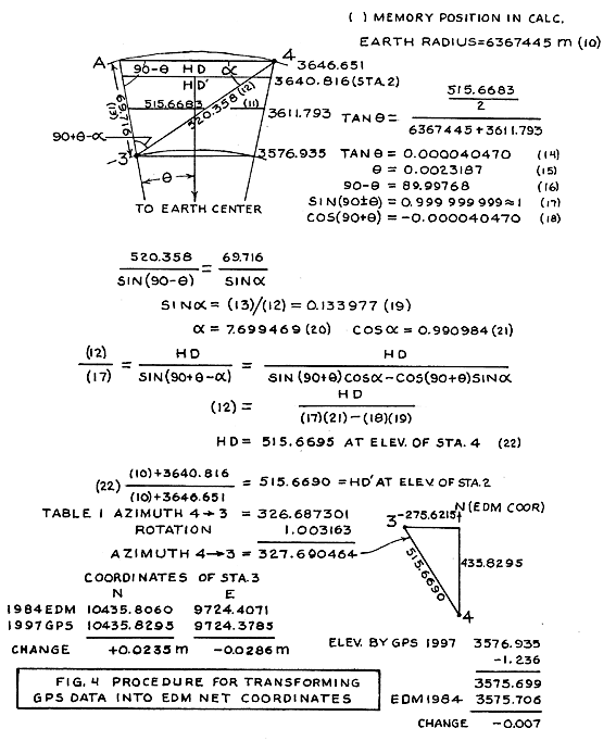
The simplest method to compare the GPS positions with the earlier surveys is to transform the GPS positions into the local coordinate system, using the slope distance between stations, which is independent of the coordinate system in which it is measured. The slope distances of seven lines were compared, 1984 EDM with 1997 GPS. Four of those were chosen for which the changes in slope distance were 3 mm or less. The azimuths of those lines in the two systems were compared and a weighted average of the differences computed. This indicated that GPS azimuths need to be rotated clockwise 1.003163 degrees to align with the local coordinate system. A comparison of the local coordinate system elevation for station 4 of 3645.415 m with the GPS height above mean sea level (NAVD88) of 3646.651 m indicated that all GPS heights need to be lessened by 1.236 m to be compared with elevations in the local coordinate system.
The detailed procedure for transforming GPS positions into the local coordinate system is given below and in figure 4 by an example of computing the position in 1997 of station 3 from the base station 4.
Figure 4.-- Procedure for transforming GPS data into EDM net coordinates.
1. Make a sketch (fig. 4), not to scale, showing in vertical section the relative positions of stations 3 and 4, the earth curvature (exaggerated), and the reported GPS data that may be necessary for the transforming procedure. This includes the slope distance, horizontal distance at the mean elevation between stations 3 and 4, and heights above mean sea level.
2. Determine the value of q , which is the angle subtended at the Earth’s center by half of the horizontal distance at mid-elevation between 3 and 4, reported in Table 1. Compute sin (90-q ) and cos (90-q ).
3. In the triangle A-4-3, and using the law of sines, compute the angle A-4-3, which is shown as a , and determine sin a and cos a .
4. Using again the law of sines in the triangle A-4-3, compute the length of HD, which is the horizontal distance A-4 at the elevation of station 4.
5. Reduce HD to HD’, the horizontal distance at elevation of station 2, in order to make comparison with the earlier EDM triangulation net, which is at the elevation of station 2.
6. Correct the reported GPS azimuth of the line 4 to 3 by adding 1.003163 degrees to obtain 327.690464, thus rotating HD’ into the orientation of the EDM net.
7. Using the distance HD’ and its azimuth from station 4, compute the GPS position of station 3 in the EDM net coordinates.
8. Subtract 1.236 m from the reported GPS elevation of station 3 (NAVD88) to compare with earlier elevations in the EDM coordinate system.
Horizontal and vertical coordinates of all the stations with the year of observation are given in Table 2. Plots of the horizontal positions and elevations of the stations are shown in figures 5 to 9.
Table 1.-- GPS observations of points in EDM network. WGS84 is the World Geodetic System 1984. NAD83 is the North American Datum 1983. NAVD88 is the North American Vertical Datum 1988. WGS84 coordinates of V4 are Latitude N 39 09 42.40829, Longitude W 106 19 27.12173, Ellipsoid Height 2830.400. NA=Not applicable because the point is a base station (P4) or data is from the initial GPS observation.
|
Point Name |
Base Station |
Date Observed (m/d/y) |
Slope Distance from Base Station (m) and standard deviation (m) |
Latitude (WGS84, degrees minutes seconds) and standard error (m) |
Longitude (WGS84, degrees minutes seconds) and standard error (m) |
Ellipsoid Height (m) and standard error (m) |
Northing, NAD83, Colorado State Plane Coordinate, central zone (m) |
Easting, NAD83, Colorado State Plane Coordinate, central zone (m) |
Mean Sea Level Height (NAVD88, m) |
Horizontal Grid Distance, base station to remote station (m) |
Horizontal Ground Distance, base station to remote station (m) |
Azimuth, base station to remote station (degrees) |
|
P4 |
V4/Vail Pass |
8/17/97 |
NA |
N 39 14 29.40594 ±0.006 |
W 106 27 21.54368 ±0.006 |
3633.767 ±0.008 |
461552.296 |
831877.161 |
3646.650 |
NA |
NA |
NA |
|
D |
4 |
8/18/97 |
2638.932 ±0.009 |
N 39 15 42.63574 ±0.005 |
W 106 28 18.34450 ±0.005 |
3600.227±0.007 |
463824.812 |
830539.343 |
3613.062 |
2637.060 |
2638.718 |
329.51491 |
|
1 |
4 |
8/18/97 |
166.742 ±0.006 |
N 39 14 32.97799 ±0.003 |
W 106 27 26.73916 ±0.003 |
3623.117 ±0.005 |
461663.753 |
831753.745 |
3635.999 |
166.295 |
166.400 |
312.0852 |
| 1 | 4 | 8/25/99 |
166.742 ±0.008 |
N 39 14.32.97816 ±0.004 | W 106 7 26.73901 ±0.004 | 3623.121 ±0.006 | 461663.758 | 831753.748 | 3636.001 | 166.297 | 166.402 | 312.0872 |
|
2 |
4 |
8/18/97 |
178.159 ±0.007 |
N 39 14 29.80207 ±0.003 |
W 106 27 28.94719 ±0.003 |
3627.934 ±0.005 |
461566.381 |
831699.768 |
3640.816 |
177.951 |
178.064 |
274.5398 |
|
6 |
4 |
8/18/97 |
352.729 ±0.006 |
N 39 14 19.11191 ±0.003 |
W 106 27 15.18151 ±0.003 |
3618.966 ±0.005 |
461233.272 |
832026.380 |
3631.857 |
352.197 |
352.419 |
154.9328 |
|
B |
4 |
8/18/97 |
1965.567 ±0.008 |
N 39 15 05.12776 ±0.004 |
W 106 28 28.85164 ±0.003 |
3432.060 ±0.006 |
462670.939 |
830275.065 |
3444.918 |
1953.989 |
1955.192 |
304.9242 |
|
1 |
6 |
8/18/97 |
509.890 ±0.006 |
N 39 14 32.97799 ±0.003 |
W 106 27 26.73913 ±0.003 |
3623.116 ±0.005 |
461663.753 |
831753.745 |
3635.998 |
509.552 |
509.873 |
327.6528 |
|
B |
D |
8/18/97 |
1196.358 ±0.007 |
N 39 15 05.12766 ±0.004 |
W 106 28 28.85177 ±0.004 |
3432.070 ±0.005 |
462670.936 |
830275.062 |
3444.929 |
1183.754 |
1184.479 |
192.9004 |
|
3 |
4 |
8/19/97 |
520.358 ±0.009 |
N 39 14 43.27431 ±0.005 |
W 106 27 33.53580 ±0.004 |
3564.062 ±0.006 |
461982.963 |
831594.129 |
3576.935 |
515.346 |
515.668 |
326.6873 |
| 3 | 4 | 8/25/99 | 520.358 ±0.009 |
N 39 14 43.27432 ±0.005 |
W 106 27 33.53588 ±0.004 | 3564.069 ±0.007 | 461982.963 | 831594.129 | 3576.940 | 515.347 | 515.670 | 326.6871 |
|
2 |
4 |
8/19/97 |
178.160 ±0.008 |
N 39 14 29.80204 ±0.004 |
W 106 27 28.94723 ±0.003 |
3627.943 ±0.005 |
461566.380 |
831699.767 |
3640.824 |
177.952 |
178.064 |
274.5394 |
|
7 |
4 |
8/19/97 |
2626.953 ±0.007 |
N 39 14 49.76553 ±0.004 |
W 106 29 07.84914 ±0.003 |
3653.638 ±0.005 |
462207.327 |
829334.975 |
3666.510 |
2625.219 |
2626.881 |
284.4488 |
|
K |
4 |
8/19/97 |
1049.526 ±0.010 |
N 39 14 06.79170 ±0.005 |
W 106 27 54.19417 ±0.005 |
3661.307 ±0.007 |
460863.258 |
831086.858 |
3674.202 |
1048.500 |
1049.165 |
228.9159 |
|
3 |
7 |
8/19/97 |
2273.456 ±0.008 |
N 39 14 43.27436 ±0.004 |
W 106 27 33.53575 ±0.003 |
3564.059 ±0.006 |
461982.964 |
831594.130 |
3576.932 |
2270.269 |
2271.693 |
95.6716 |
|
K |
2 |
8/19/97 |
933.944 ±0.009 |
N 39 14 06.79174 ±0.005 |
W 106 27 54.19414 ±0.005 |
3661.305 ±0.006 |
460863.259 |
831086.858 |
3674.200 |
932.759 |
933.350 |
221.0786 |
Table 2.--Coordinates in the local EDM system and altitudes, in meters, of the Bald Eagle Mountain survey stations at the years of observation.
| Sta | Coords | 1975 | 1977 | 1982 | 1984 | 1997(GPS) | 1999(GPS) |
| North | 10113.662 | 10113.662 | 10113.676 | 10113.671 | 10113.672 | 10113.677 | |
| 1 | East | 9878.485 | 9878.497 | 9878.479 | 9878.481 | 9878.478 | 9878.481 |
| Alt. | 3634.764 | 3634.774 | 3634.772 | 3634.770 | 3634.763 | 3634.765 | |
| North | 10017.212 | 10017.208 | 10017.206 | 10017.194 | 10017.199 | ||
| 2 | East | 9822.782 | 9822.792 | 9822.770 | 9822.771 | 9822.769 | |
| Alt. | 3639.574 | 3639.594 | 3639.586 | 3639.590 | 3639.580 | ||
| North | 10435.774 | 10435.781 | 10435.798 | 10435.812 | 10435.830 | 10435.829 | |
| 3 | East | 9724.410 | 9724.444 | 9724.414 | 9724.404 | 9724.379 | 9724.377 |
| Alt. | 3575.708 | 3575.729 | 3575.709 | 3575.706 | 3575.700 | 3575.704 | |
| North | 10000.000 | Assumed | |||||
| 4 | East | 10000.000 | Stable | ||||
| Alt. | 3645.415 | ||||||
| North | 9678.218 | 9678.220 | 9678.217 | 9678.209 | 9678.210 | 9678.220 | |
| 6 | East | 10143.695 | 10143.694 | 10143.696 | 10143.699 | 10143.701 | 10143.714 |
| Alt. | 3630.613 | 3630.615 | 3630.625 | 3630.624 | 3630.621 | 3630.635 | |
| North | 10699.8 | 10699.879 | |||||
| 7 | East | 7468.081 | 7468.076 | ||||
| Alt. | 3665.185 | 3665.275 | |||||
| North | 11147.526 | 11147.263 | 11147.243 | 11147.241 | |||
| B | East | 8417.152 | 8416.754 | 8416.734 | 8416.741 | ||
| Alt. | 3443.327 | 3443.597 | 3443.595 | 3443.682 | |||
| North | 12297.037 | ||||||
| D | East | 8701.355 | |||||
| Alt. | 3611.826 | ||||||
| North | 9324.484 | 9324.488 | 9324.4730 | 9324.478 | |||
| K | East | 9197.226 | 9197.220 | 9197.231 | 9197.249 | ||
| Alt. | 3672.961 | 3672.901 | 3672.922 | 3672.966 |
Station 7 was established in 1984 on a high promontory west of Busk Creek to replace the intended stable point B, which had been showing large and erratic movements of unknown origin. Because station 7 was difficult to reach without a helicopter it was not occupied or observed in 1989. But there is close agreement, within less than 3 mm, of the horizontal positions of station 7 in 1984, determined by EDM over a distance of 2.5 km from station 2, and by GPS in 1997. This agreement allows the following inferences: 1) that both station 4 and station 7 can be assumed to be stable, 2) that the surveying procedures used for locating station 7 with the EDM in 1984 are satisfactory and, by extension, the agreement lends support to the locations of other stations determined by EDM, 3) that the GPS surveying procedures used for locating station 7, and probably other points, relative to station 4 are satisfactory, and 4) that the method presented above and in figure 4 is satisfactory for transforming GPS data to positions in the earlier EDM triangulation-trilateration net.
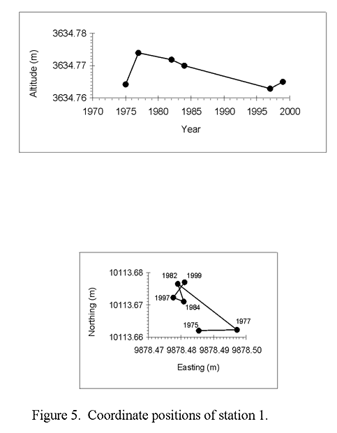
Figure 5.--Coordinate positions of station 1.
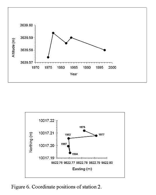
Figure 6.--Coordinate positions of station 2.
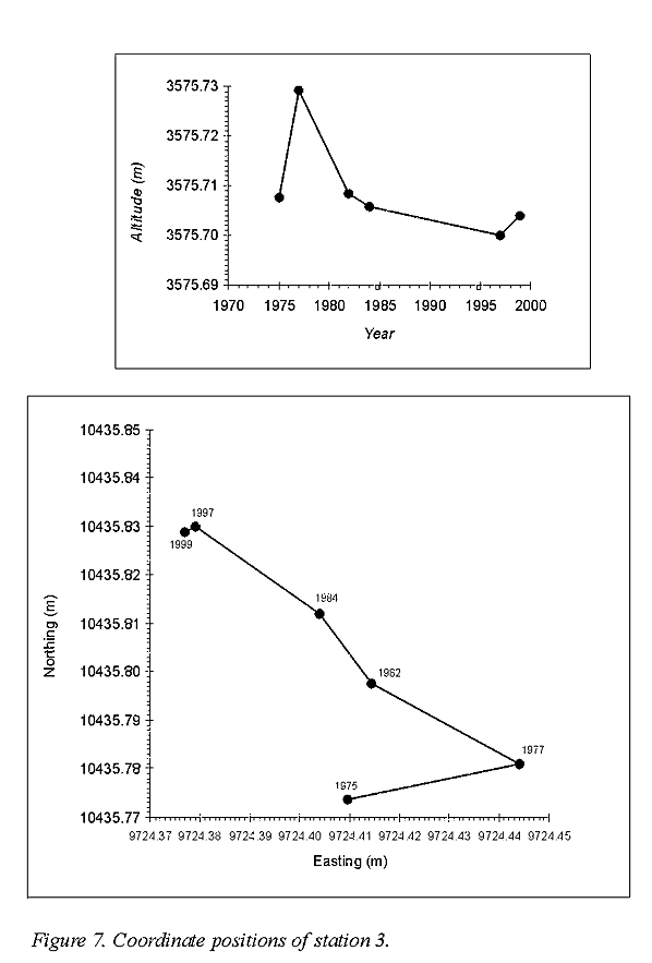
Figure 7.--Coordinate positions of station 3.
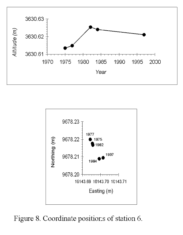
Figure 8.--Coordinate positions of station 6.
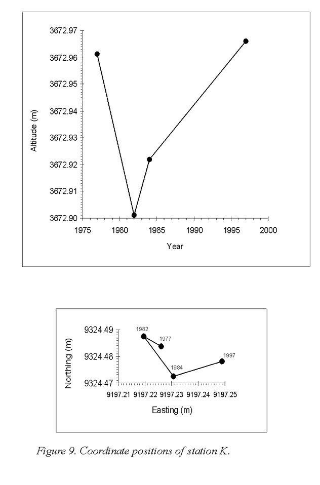
Figure 9.--Coordinate positions of station K.
MEASURED DISPLACEMENTS
(Refer to figures 5 to 9)
Most observation points are 18-inch copper-clad steel stakes with a flat head marked with a center punch. These were driven until the heads were flush with the ground or to refusal. Station 1, in a place that might be subject to disturbance by passers-by, is the head of a small screw cemented in a rock.
Station 1. Net movement from 1977 to 1997 was 2.1 cm in the direction N 62 W., directly away from the ridge-top graben and normal to the local contours. The movement from 1975 to 1982, to the east and then to the northwest about 1.6 cm, may in part be the result of changing the type of EDM instrument from AGA to K&E. From 1982 to 1997 the horizontal movement was less than 0.5 cm, and the vertical movement from 1977 to 1997 was steadily down at the rate of about 0.5 mm per year. Between 1997 and 1999 station 1 moved about 6 mm to the northeast and 2 mm up.
Station 2. Net movement from 1975 to 1997 was 2.0 cm S 52 W, downhill normal to the local contours. The average vertical displacement has been down at a rate of about 0.6 mm per year.
Station 3. This station is immediately northwest of the lowest of the trenches that have resulted from spreading of the ridge, and is at the upper edge of a very steep bare rock slope to the west (see photo on title page). Expectedly, its horizontal movement has been more than that of any other station¾ 8.3 cm from 1977 to 1999 in a N 54 W direction, which is nearly perpendicular to the trenches uphill and to the contours of the slope below. The net vertical displacement has been 0.2 cm down from 1975 to 1999, although measurements through the years for vertical movements have been erratic over a range of 5 cm and less accurate than horizontal movements. The distance of station 3 from station 7, which is to the west on the opposite side of the valley of Busk Creek, has lessened 2.7 cm between 1984 and 1997, which is just what would be expected from the movement of station 3 in that period.
Station 4. Assumed to remain stable. Movements of all other stations are relative to station 4.
Station 5. Has been abandoned. This station was a mirror reflector mounted close to the ground, facing toward station 3, above the road to Hagerman Pass, about five hundred meters north of the portal of the Carlton Tunnel.
Station 6. In the period 1975-1997 station 6 moved 1.0 cm S 37 E and 0.8 cm up. The direction of horizontal movement has been opposite to that of Station 1 on the other side of the ridge-top graben and obliquely toward the headwall of a large cirque a few hundred meters to the southeast.
Station 7. This station was placed in 1984 on a high rocky promontory, after the apparent erratic behavior of station B, to serve as a stable reference point on the west side of the valley of Busk Creek across from the area of spreading trenches. There appears to have been no horizontal movement from 1984 to 1997.
Station B. This station was set in 1977 on a granite outcrop to serve as a stable reference point on the west side of Busk Creek valley. Its apparent large and erratic movements 1977-1984, discussed in Open File 90-543, remain a mystery. However, movement may have ceased, because the 1997 GPS position is less than 4 mm from the EDM position in 1984.
Station D. This station was established in 1989 to furnish a stable point west of Busk Creek that was more easily accessible than station 7 and to which EDM equipment could be carried from a vehicle on the Hagerman Pass road. Its position in 1989 could not be accurately determined but it was accurately located by GPS in 1997.
Station K. This station was placed in 1977 on the south side of the broad valley south of stations 4 and 6. Its movements 1977-1997 were irregular with a net horizontal displacement of 2.3 cm S 76 E and vertical displacement of 0.5 cm up. It is on a gentle slope, not on a rock outcrop, and may be subject to freeze and thaw movements of ground at an altitude of 3673 meters (12050 ft).
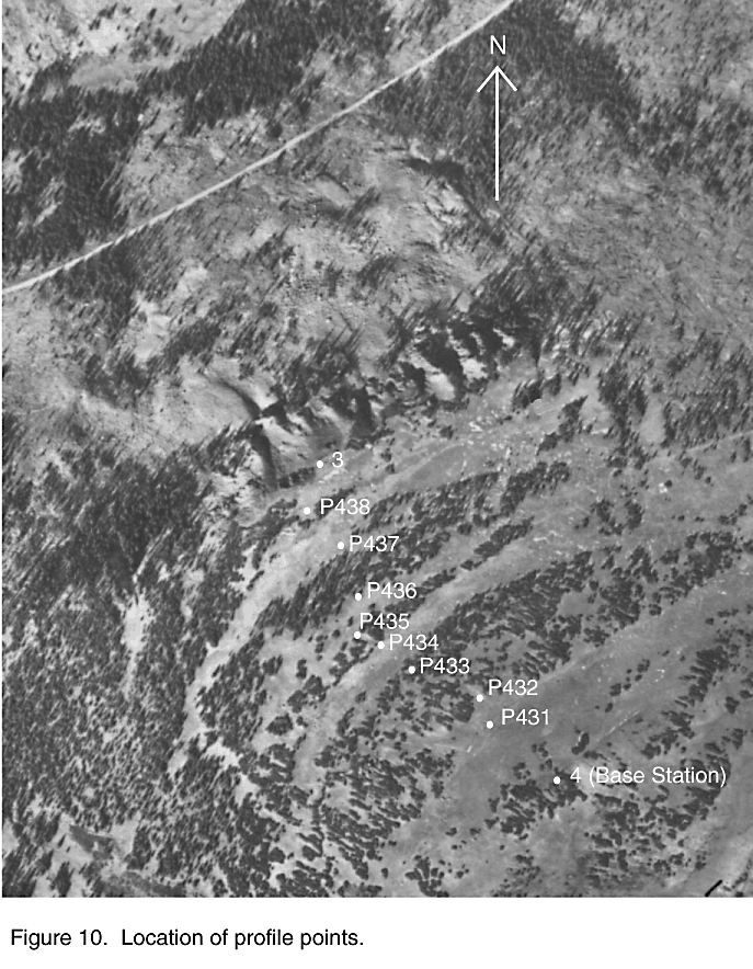
During the August, 1997, surveys a continuous profile, extending down from station 4 across all the trenches to station 3 was measured using real- time GPS. Eight permanent stations were placed along the profile. The locations of the profile stations are shown in figure 10, and the topography along the profile in vertical section is shown in figure 11. The stations of the profile were reoccupied two years later in August, 1999; their coordinates and changes during the interval 1997-1999 are shown in Table 3. Some of the differences in northing and easting exceed 1 cm (for example, P433, table 3) and may represent small real movements. For the most part, however, results from 1999 suggest that little or no movement occurred along the profile between 1997 and 1999.
Figure 10.--Location of profile points.
EDM AND GPS COMPARED
Comparison of EDM positions of points that are stable or nearly so with positions determined by GPS suggests that the precision of horizontal positions in the two methods is comparable, of the order of 1 cm or less, in the relatively small net of a few kilometers extent. The precision of vertical positions is much less for both methods, although relative differences in elevations between nearby stations are probably defined better by EDM than by GPS. The absolute elevation of stations far above distant benchmarks is better and more easily done by GPS.
The ease of field operations is considerably greater with GPS than it was in our EDM operations, owing to lighter loads to be carried at high altitudes, no tedious pointing of optics and reading or recording of angles and distances, and especially, no requirement for intervisibility between stations. Reduction of raw EDM data to forms suitable for computer solution of triangles and quadrilaterals appears to be more time consuming than reduction of GPS data with the computer and special software programs. GPS measurements are, however, subject to their own possible sources of error including variation in the propagation properties of the upper atmosphere and ionosphere and, more rarely, to the deliberate degradation of signals by the Defense Department. Most of these sources of error can be corrected by using currently available software.
Figure 11.-- Real-time GPS profile data projected onto a vertical plane between the point 4 (base station) and point P3. Point locations measured using rapid static GPS methods are shown. Gaps in the profile are caused by poor GPS signal in heavy tree cover. Vertical exaggeration is 4x.
Table 3.-- Profile Point Data. WGS84 is the World Geodetic System 1984. NAD83 is the North American Datum 1983. NAVD88 is the North American Vertical Datum 1988. NA=Not applicable because the point is a base station (P4) or data is from the initial GPS observation.
|
Point Name |
Date Observed (m/d/y) |
Slope Distance from Base Station (m) and standard deviation (m) |
Latitude (WGS84, degreesminutes seconds) and standard error (m) |
Longitude (WGS84, degrees minutes seconds) and standard error (m) |
Ellipsoid Height (m) and standard error (m) |
Northing, NAD83, Colorado State Plane Coordinate, central zone (m) |
Easting, NAD83, Colorado State Plane Coordinate, central zone (m) |
Mean Sea Level Height (NAVD88, m) |
Difference in Northing values (1997-1999, m) |
Difference in Easting values (1997-1999, m) |
Difference in Mean Sea Level Height values (1997-1999, m) |
|
4 |
8/17/97 |
NA |
N 39 14 29.40594 |
W 106 27 21.54368 |
3633.767 |
461552.296 |
831877.161 |
3646.650 |
NA |
NA |
NA |
|
P431 |
8/20/97 |
101.845 ±0.009 |
N 39 14 32.30475 ±0.005 |
106 27 23.52463 ±0.004 |
3623.169 ±0.007 |
461642.182 |
831830.603 |
3636.052 |
NA |
NA |
NA |
|
P431 |
8/25/99 |
101.853 ±0.009 |
N 39 14 32.30514 ±0.005 |
106 27 23.52438 ±0.004 |
3623.165 ±0.006 |
461642.194 |
831830.609 |
3636.046 |
+0.012 |
+0.006 |
-0.006 |
|
P432 |
8/20/97 |
156.061 ±0.009 |
N 39 14 33.90033 ±0.005 |
W 106 27 24.51538 ±0.004 |
3627.570 ±0.006 |
461691.632 |
831807.365 |
3640.449 |
NA |
NA |
NA |
|
P432 |
8/25/99 |
156.063 ±0.008 |
N 39 14 33.90043 ±0.004 |
W 106 27 24.51527 ±0.004 |
3627.566 ±0.006 |
461691.635 |
831807.368 |
3640.446 |
+0.003 |
+0.003 |
-0.003 |
|
P433 |
8/20/97 |
235.720 ±0.008 |
N 39 14 35.51555 ±0.004 |
W 106 27 27.34237 ±0.003 |
3607.977 ±0.006 |
461742.152 |
831740.106 |
3620.856 |
NA |
NA |
NA |
|
P433 |
8/25/99 |
235.743 ±0.010 |
N 39 14 35.51639 ±0.005 |
W 106 27 27.34259 ±0.004 |
3607.983 ±0.008 |
461742.178 |
831740.101 |
3620.862 |
+0.026 |
-0.005 |
+0.006 |
|
P434 |
8/20/97 |
279.691 ±0.009 |
N 39 14 36.44962 ±0.005 |
W 106 27 28.71080 ±0.004 |
3596.139 ±0.006 |
461771.301 |
831707.598 |
3609.017 |
NA |
NA |
NA |
|
P434 |
8/25/99 |
279.684 ±0.009 |
N 39 14 36.44957 ±0.005 |
W 106 27 28.71034 ±0.004 |
3596.130 ±0.006 |
461771.299 |
831707.609 |
3609.008 |
-0.002 |
+0.011 |
-0.009 |
|
P435 |
8/20/97 |
292.381 ±0.009 |
N 39 14 36.78378 ±0.005 |
W 106 27 29.04901 ±0.004 |
3598.690 ±0.006 |
461781.690 |
831699.597 |
3611.568 |
NA |
NA |
NA |
|
P435 |
8/25/99 |
292.376 ±0.007 |
N 39 14 36.78369 ±0.004 |
W 106 27 29.04870 ±0.004 |
3598.678 ±0.005 |
461781.687 |
831699.605 |
3611.555 |
-0.003 |
+0.008 |
-0.013 |
|
P436 |
8/20/97 |
344.718 ±0.007 |
N 39 14 38.08869 ±0.004 |
W 106 27 30.37316 ±0.003 |
3587.205 ±0.005 |
461822.262 |
831668.272 |
3600.082 |
NA |
NA |
NA |
|
P436 |
8/25/99 |
344.718 ±0.009 |
N 39 14 38.08891 ±0.005 |
W 106 27 30.37287 ±0.004 |
3587.216 ±0.007 |
461822.269 |
831668.279 |
3600.092 |
+0.007 |
+0.007 |
+0.010 |
|
P437 |
8/20/97 |
434.953 ±0.010 |
N 39 14 40.74580 ±0.006 |
W 106 27 31.92601 ±0.004 |
3565.269 ±0.007 |
461904.588 |
831631.904 |
3578.143 |
NA |
NA |
NA |
|
P437 |
8/25/99 |
434.954 ±0.012 |
N 39 14 40.74588 ±0.006 |
W 106 27 31.92582 ±0.005 |
3565.259 ±0.008 |
461904.590 |
831631.908 |
3578.133 |
+0.002 |
+0.004 |
-0.010 |
|
P438 |
8/20/97 |
482.425 ±0.010 |
N 39 14 42.00709 ±0.005 |
W 106 27 33.08087 ±0.004 |
3563.636 ±0.007 |
461943.773 |
831604.624 |
3576.509 |
NA |
NA |
NA |
|
P438 |
8/25/99 |
482.430 ±0.011 |
N 39 14 42.00747 ±0.006 |
W 106 27 33.08066 ±0.005 |
3563.644 ±0.008 |
461943.784 |
831604.630 |
3576.517 |
+0.011 |
+0.006 |
+0.008 |
|
3 |
8/19/97 |
520.358 ±0.009 |
N 39 14 43.27431 ±0.005 |
W 106 27 33.53580 ±0.004 |
3564.062 ±0.006 |
461982.963 |
831594.129 |
3576.935 |
NA |
NA |
NA |
|
3 |
8/25/99 |
520.358 ±0.009 |
N 39 14 43.27432 ±0.005 |
W 106 27 33.53588 ±0.004 |
3564.069 ±0.007 |
461982.963 |
831594.127 |
3576.940 |
0.000 |
+0.002 |
-0.005 |
DISCUSSION AND CONCLUSIONS
Theoretical analyses of spreading mechanics have been made (Savage and Varnes, 1987), but measurements in the field over an extended time are uncommon. In particular, knowledge of vertical movements of points on a spreading mountain, to an accuracy comparable with that of horizontal movements, is becoming essential to our further understanding of the relatively unknown mechanics of sackungen. We recommend, therefore, that precise determination of horizontal movements be supplemented with precise leveling, wherever practical, between stations in the Bald Eagle Mountain triangulation net and GPS profile. The bar-code-reading level system would be lightweight, fast, and sufficiently accurate.
We believe that spreading movements of the ridge under study are probably still taking place; these are slow by standards of human activity, but are quite rapid for a geologic process. The evidence is:
1. The horizontal movement by station 3 of 8.3 cm in the 20 years from 1977 to 1997 is in a direction directly away from the trenches uphill and the ridge-top graben, as should be expected if spreading is taking place.
2. The movement of station 1 just west of the ridge-top graben, although only 1.3 cm in the interval 1975-1997, was down and directly away from the graben.
3. The movement of station 6, which is about 400 m southeast of the graben, although only 1.0 cm in the interval 1975-1997, was to the southeast away from the graben and opposite in direction to the movement of station 1.
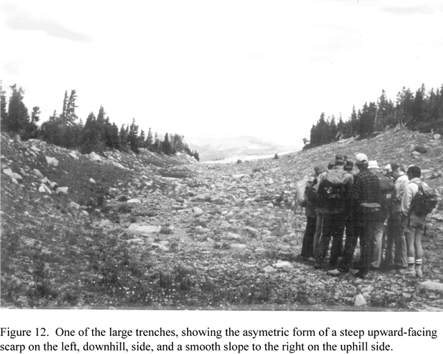
To speculate a little, the movement of station 3 of about 4 mm per year, if constant over about 10,000 years since the valley of Busk Creek was deglaciated, would amount to about 40 meters. Distributed over the 3 or 4 trenches below the graben, this is not an unreasonable amount, considering the present size of the trenches (See fig. 11 and fig. 12)
Figure 12.--One of the large trenches, showing the asymetric form of a steep upward-facing scarp on the left, downhill, side, and a smooth slope to the right on the uphill side.
ACKNOWLEDGEMENTS
We wish to acknowledge the essential contributions of Dorothy Hall, William K. Smith, and Katharine Varnes to surveys in the years 1975-1989. And we appreciate help with the fieldwork in 1997 given by Boris Villemus and David Berger of ENTPE, Lyon, France, and by Marta Chiarle and Marco Giardino of Torino, Italy.
REFERENCES
Savage, W. Z., and Varnes, D. J., 1987, Mechanics of gravitational spreading of steep-sided ridges (ìsackungî): International Association of Engineering Geology Bulletin, n. 35, p. 31-36.
Van Sickle, J., 1996, GPS for land surveyors: Ann Arbor Press, Chelsea, Michigan, 209 p.
Varnes, D. J., Radbruch-Hall, D. H., and Savage, W. Z., 1989, Topographic and structural conditions in areas of gravitational spreading of ridges in the Western United States: U. S. Geological Survey Professional Paper 1496, 32 p., 1 table, 42 figs., 2 geologic maps.
Varnes, D. J., Radbruch-Hall, D. H., Varnes, K. L., Smith, W. K., and Savage, W. Z., 1990, Measurement of ridge-spreading movements (Sackungen) at Bald Eagle Mountain, Lake County, Colorado, 1975-1989: U. S. Geological Survey Open-File Report 90-543, 13 p.
| AccessibilityFOIAPrivacyPolicies and Notices | |
| |
|