
Rock-fall Hazard Assessment of the Aspen Forest Trail, Navajo National Monument, Arizona
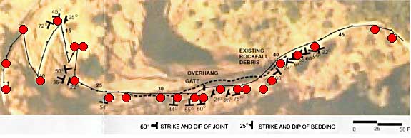
Fig. 6 - Plot of survey stations (shown as small black numbered dots along solid line) from west (Sta. 1 at left) to east (Sta. 48 at right) along Aspen Forest Trail by Lachel Hansen & Associates (1985). Larger red dots denote sites of Q-values. Dashed line indicates position of rock cliff above trail. Strike and dip shown on figure are from Lachel Hansen & Associates (1985).
| AccessibilityFOIAPrivacyPolicies and Notices | |
| |
|