
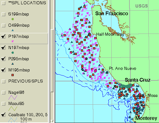
Locations of samples collected from 1995 through 1999 are recorded in M195MBSP, P295MBSP, N197MBSP, P197MBSP, O499MBSP, and S199MBSP.
These files are part of a geographic information system of spatially referenced data related to the USGS Coastal and Marine Geology Program "Monterey Bay National Marine Sanctuary Project" <http://walrus.wr.usgs.gov/mbms>. The data were collected and analyzed between 1994 and 2000.
Survey specific FGDC-compliant metadata and other information are available at the following URLs:
<http://walrus.wr.usgs.gov/infobank/m/m195mb/html/m-1-95-mb.meta.html> <http://walrus.wr.usgs.gov/infobank/m/p295mb/html/p-2-95-mb.meta.html> <http://walrus.wr.usgs.gov/infobank/m/n197mb/html/n-1-97-mb.meta.html> <http://walrus.wr.usgs.gov/infobank/m/p197mb/html/p-1-97-mb.meta.html> <http://walrus.wr.usgs.gov/infobank/m/o499mb/html/o-4-99-mb.meta.html> <http://walrus.wr.usgs.gov/infobank/m/s199mb/html/s-1-99-mb.meta.html>
Wong, Florence L. , and Hamer, Michael R. , 2001, Location of samples collected in 1995-1999 in the Monterey Bay National Marine Sanctuary:.This is part of the following larger work.Online Links:
Wong, F.L., and Eittreim, S.E., 2001, Continental Shelf GIS for the Monterey Bay National Marine Sanctuary: U.S. Geological Survey Open-File Report 01-179, U.S. Geological Survey, Menlo Park, CA.Online Links:
This is a Point data set. It contains the following vector data types (SDTS terminology):
Planar coordinates are encoded using coordinate pair
Abscissae (x-coordinates) are specified to the nearest 14.232525
Ordinates (y-coordinates) are specified to the nearest 14.232525
Planar coordinates are specified in Meters
The horizontal datum used is North American Datum of 1983.
The ellipsoid used is GRS1980.
The semi-major axis of the ellipsoid used is 6378137.0.
The flattening of the ellipsoid used is 1/298.257.
Sample filenames, year and month of collection, geographic extent, and number of points in each file:
 FILE    YYYYMM    XMIN       YMIN        XMAX      YMAX   SPLS
M195MBSP 199504 -122.87425, 36.62622, -121.81105, 37.79693  109
P295MBSP 199509 -122.90928, 36.55533, -121.80174, 37.81330  105
N197MBSP 199707 -122.37930, 36.92717, -121.98520, 37.10141   77
P197MBSP 199708 -122.90629, 36.72277, -121.86097, 37.84406  226
O499MBSP 199906 -122.40520, 36.70703, -121.83510, 37.04510    9
S199MBSP 199910 -122.17825, 36.84119, -121.94952, 36.97814   22
Possible attributes in the point attribute table .PAT for each point data file. Not every attribute appears in all the .PATs.
LONGITUDE83  longitude of point (decimal degrees), datum NAD83
LATITUDE83   latitude of point (decimal degrees), datum NAD83
CRUISEID     cruise identifier, for example M195MB
NAVTIMEC     navigation time when sample was collected in
             YYYYDDDHHMMSSS format where YYYY is year,
             DDD day of the year (1-366), HH hour (0-23),
             MM minutes (0-59), SSS seconds (0-59) and tenths
             of seconds (0-9)
DEPTH_M      depth of water (meters) at sample site
SAMPLEID     sample identifier
EQUIPMENT    type of equipment used to collect sample
EPA_NO       sample identifier based on U.S. Environmental
             Protection Agency (EPA) sampling scheme
LENGTH_M     length of core (meters)
    **  REDEFINED ITEMS  ** /* for labeling
YEAR         4-character year part of NAVTIMEC
DAY          3-character day part of NAVTIMEC
HOUR         2-character hour part of NAVTIMEC
MIN          2-character minute part of NAVTIMEC
SEC          2-character second part of NAVTIMEC
TSEC         1-character tenths of seconds part of NAVTIMEC
Florence L. Wong
United States Geological Survey (USGS)
Geologist, GIS Coordinator
USGS, MailStop 999, 345 Middlefield Road
Menlo Park, CA 94025-3561
USA
(650) 329-5327 (voice)
(650) 329-5190 (FAX)
fwong@usgs.gov
These data are intended for science researchers, students, policy makers, and the general public. The data can be used with geographic information systems (GIS) software to display geologic and oceanographic information about the shallower areas of the Monterey Bay National Marine Sanctuary.
Except for a few points, point files include only those points for which a 'RECOVERY' was recorded. 'NO RECOVERY' points were added if sample analyses referred to that point. This occurred when small amounts of sample were scraped off the sampling device which had otherwise failed to retain a sample.
Point features present.
Are there legal restrictions on access or use of the data?
- Access_Constraints:
- None
- Use_Constraints:
- Please recognize the U.S. Geological Survey (USGS) as the source of this information.
Although these data have been used by the U.S. Geological Survey, U.S. Department of the Interior, no warranty expressed or implied is made by the U.S. Geological Survey as to the accuracy of the data.
The act of distribution shall not constitute any such warranty, and no responsibility is assumed by the U.S. Geological Survey in the use of this data, software, or related materials.
This information is not intended for navigational purposes.
Any use of trade, firm, or product names is for descriptive purposes only and does not imply endorsement by the U.S. Government.
United States Geological Survey (USGS)
c/o Florence L. Wong
Geologist, GIS Coordinator
USGS, MailStop 999, 345 Middlefield Road
Menlo Park, CA 94025-3561
USA
(650) 329-5327 (voice)
(650) 329-5190 (FAX)
fwong@usgs.gov
USGS Open-File Report 01-179
Please recognize the U.S. Geological Survey (USGS) as the source of this information.Although these data have been used by the U.S. Geological Survey, U.S. Department of the Interior, no warranty expressed or implied is made by the U.S. Geological Survey as to the accuracy of the data.
Any use of trade, product, or firm names is for descriptive purposes only and does not imply endorsement by the U.S. Government.
The act of distribution shall not constitute any such warranty, and no responsibility is assumed by the U.S. Geological Survey in the use of this data, software, or related materials.
| Data format: | sample location points with attributes in format ArcInfo (version 8.0.2) Size: 1 megabyte |
|---|---|
| Network links: |
<http://geopubs.wr.usgs.gov/open-file/of01-179/> |
United States Geological Survey (USGS)
c/o Florence L. Wong
Geologist, GIS Coordinator
USGS, MailStop 999, 345 Middlefield Road
Menlo Park, CA 94025-3561
USA
(650) 329-5327 (voice)
(650) 329-5190 (FAX)
fwong@usgs.gov