 Summary Summary
Open-File Report OF 01-293 contains a digital geologic map database of the Telegraph Peak 7.5’ quadrangle, San Bernardino County, California that includes:
- ARC/INFO (Environmental Systems Research Institute, http://www.esri.com) version 7.2.1 double precision coverages of the various elements of the geologic map.
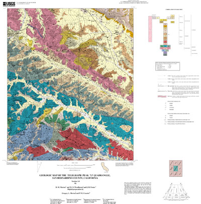
- A PostScript file to plot the geologic map on a topographic base, and containing a Correlation of Map Units diagram, a Description of Map Units, an index map, and a regional structure map.
- Portable Document Format (.pdf) files of:
a. This Readme; includes in Appendix I, data contained in fif_met.txt
b. The same graphic as plotted in 2 above. Test plots have not produced 1:24,000-scale map sheets. Adobe Acrobat pagesize setting influences map scale.
The Correlation of Map Units and Description of Map Units is in the editorial format of USGS Miscellaneous Investigations Series (I-series) maps but has not been edited to comply with I-map standards. Within the geologic map data package, map units are identified by standard geologic map criteria such as formation-name, age, and lithology. Even though this is an author-prepared report, every attempt has been made to closely adhere to the stratigraphic nomenclature of the U. S. Geological Survey. Descriptions of units can be obtained by viewing or plotting the .pdf file (3b above) or plotting the postscript file (2 above). If roads in some areas, especially forest roads that parallel topographic contours, do not show well on plots of the geologic map, we recommend use of the USGS Telegraph Peak 7.5’ topographic quadrangle in conjunction with the geologic map.
|
First posted September 25, 2001
Readme's and metadata
Data
Files for viewing and plotting
- Map PDF (3.3 MB)
Full-color geologic map as a formatted PDF file
- Map PS.GZ (3.3 MB)
Full-color geologic map of the Telegraph Peak quadrangle at 1:24,000 scale on the topographic base, including a detailed Correlation of Map Units diagram, and an expanded Description of Map Units, in plottable PostScript format.
Part or all of this report is presented in Portable Document Format (PDF). For best results viewing and printing PDF documents, it is recommended that you download the documents to your computer and open them with Adobe Reader. PDF documents opened from your browser may not display or print as intended. Download the latest version of Adobe Reader, free of charge.
|

