| |
Surficial Geology and Distribution of Post-Impoundment Sediment in Las Vegas Bay, Lake Mead
Based on U.S. Geological Survey Open-File Report 01-070
1David C. Twichell, 1VeeAnn A. Cross, 2Mark J. Rudin, 1Kenneth F. Parolski, and 1Richard R. Rendigs
1 U.S. Geological Survey, Woods Hole, Massachusetts
2 Lake Mead/Mojave Research Institute, University of Nevada, Las Vegas, Nevada
ABSTRACT
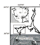
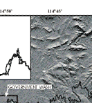
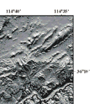
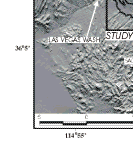
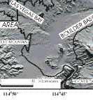
Sidescan sonar imagery and seismic-reflection profiles were collected in the northwestern part of Las Vegas Bay to map the distribution and volume of sediment that has accumulated in this part of Lake Mead since impoundment. The mapping suggests that three ephemeral streams are the primary source of this sediment, and of these, Las Vegas Wash is the largest. Two deltas off the mouth of Las Vegas Wash formed at different lake elevations and account for 41% of the total volume of post-impoundment sediment within the study area. Deltas off the other two washes (Gypsum and Government) account for only 6% of the total volume. The sediment beyond the front of the deltas is primarily mud, and it only occurs in valley floors, where it forms a flat-lying blanket that is mostly less than 1.5 m thick. Although a thin layer, the fine-grained sediment accounts for approximately 53% of the total post-impoundment sediment volume of 5.7 x 10⁶ m3 that has accumulated in the study area. This sediment appears to have been transported several kilometers from the river sources by density flows.
|
|
|
|
|
Acknowledgements
The U.S. Bureau of Reclamation funded this field program, and we acknowledge their interest and support of this mapping program. Additionally we acknowledge Gail Kaiser, Las Vegas Bay Marina, for her generosity in making one of their vessels available to us free of charge. We appreciated assistance from many other members of the staff at the Las Vegas Bay Marina who assisted with mobilization for the field program and provided dockage. The National Park Service in Boulder City, Nevada provided invaluable logistical support for the field operations, and also made their vessel, TAMARISK, available for the collection of cores. William Burke, Jim Koza, and Jon Lee, all of the National Park Service, provided invaluable help. David Foster and James Robb of the U.S.G.S. provided constructive reviews of this report.
|
D.O.I> U.S.G.S.> Coastal and Marine Geology Program | |  |
Prepared in cooperation with U.S. Bureau of Reclamation and
Lake Mead/Mojave Research Institute, University of Nevada, Las Vegas, Nevada |
[an error occurred while processing this directive]
|
|
|