
![]()
Georgia Aeromagnetic Index Map and Data Table
![]()
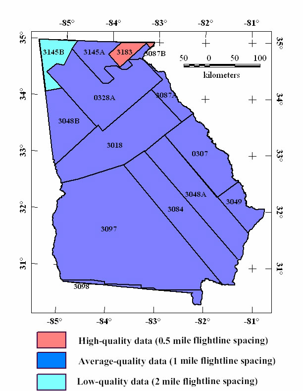
The Georgia aeromagnetic compilation map contains data from 14 separate aeromagnetic surveys. Four of these are from digitized contour maps (see USGS Open-File Report 99-557). This map is an index to the locations and flightline spacing of the original surveys. Publication references are listed in the bibliography. The raw data for surveys flown since about 1973 are available from the National Geophysical Data Center (NGDC), Boulder, Colorado. Files of digitized analog surveys may be downloaded from the USGS site: http://greenwood.cr.usgs.gov/pub/open-file-reports/ofr-99-0557/html/mag_home.htm
Table of Georgia Aeromagnetic Surveys
| USGS Number | Type | Survey Name | Year Flown | Flight Spacing | Flight Dir | Flight Altitude | Publication |
| 0307 | Analog | Savannah ARMS | 1958 | 1 mi. | NW-SE | 500 ft AG | Petty and others, 1965; USGS OFR-99-557 |
| 0328A | Analog | GNAL ARMS South '59 | 1959-1960 | 1 mi. | NW-SE | 500 ft AG | Philbin and others, 1964; USGS OFR-99-557 |
| 3018 | Analog | North-central Georgia | 1972 | 1 mi. | NW-SE | 500 ft AG | USGS OFR-73-324 |
| 3048A | Digital | East Georgia | 1974-1975 | 1 mi. | NW-SE | 500 ft AG | USGS OFR-76-181 |
| 3048B | Digital | West Georgia | 1974-1975 | 1 mi. | N-S | 500 ft AG | USGS OFR-77-345 |
| 3049 | Digital | S. Carolina-Georgia Border | 1974 | 1 mi. | E-W | 500 ft AG | USGS OFR-76-155 |
| 3084 | Digital | Southeast Georgia | 1976 | 1 mi. | NW-SE | 500 ft AG | USGS OFR-77-096 |
| 3087A | Digital | Northern Georgia Southeast | 1976 | 1 mi. | NW-SE | 500 ft AG | USGS OFR-77-190 |
| 3087B | Digital | Northern Georgia Northeast | 1976 | 1 mi. | NW-SE | 500 ft AG | USGS OFR-77-190 |
| 3097 | Digital | Southern Georgia | 1977 | 1 mi. | NW-SE | 500 ft AG | USGS OFR-79-756 |
| 3098 | Analog | Northern Florida | 1977 | 1 mi. | E-W | 500 ft AG | USGS OFR-78-891, OFR-99-557 |
| 3145A | Digital | Northwest Georgia East | 1978 | 1 mi. | E-W | 500 ft AG | USGS OFR-79-1371 |
| 3145B | Digital | Northwest Georgia West | 1978 | 2 mi. | E-W | 500 ft AG | USGS OFR-79-1369 |
| 3183 | Digital | Blood Mtn.-Chattahoochee | 1981 | 0.5 mi. | NW-SE | 500 ft AG | USGS OFR-81-935 |
|| Georgia Mag || USGS - Eastern Minerals Team || USGS - Geology || USGS ||