
|
U.S. Geological Survey
Open-File Report 01-112
Online version 1.0
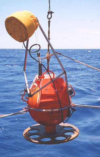 |
| USGS ocean bottom seismometer being deployed offshore Puerto Rico. |
|
CONTENTS
Executive Summary Description of the Array Instrumentation Cruise Report OBS Deployment OBS Recovery Data Processing and Analysis Acknowledgments [Main report, 1.1 MB PDF document] Appendix A: Plots for the Comparison of Four Events Across Stations [3.1 MB PDF document] Appendix B: Tables and Plots for the Comparison of 20 Local Events at Each Station [3.5 MB PDF document] Appendix C: USGS Temporary Land Station Information [27 Kb PDF document] Appendix D: Puerto Rico Seismic Network Information [26 Kb PDF document] The full report, as a PDF document suitable for printing, is 10 MB and includes all Appendices. Get a free copy of Adobe Acrobat Reader to view these PDF files. This report is also available from: USGS Information Services The formal citation for this open-file report is: Martin, J.L., ten Brink, U.S., von Hillebrandt, C., Roth, E.G., and Miller, G., 2001. Project PROBES (Puerto Rico Ocean Bottom Earthquake Survey). U.S. Geological Survey Open File Report 01-112. 86 pp. For questions about the content of this report, contact Uri ten Brink. |
EXECUTIVE SUMMARY
Puerto Rico and the Virgin Islands are located at an active tectonic plate boundary between the North American plate and the northeast corner of the Caribbean plate. 3.7 million U.S. citizens live on the islands and the population density, 392 people per square kilometer, is one of the highest in the western hemisphere. Large magnitude earthquakes and devastating tsunamis have occurred in historical times in and around the island. Lack of geological understanding of the tectonic movements in this part of the Caribbean has hampered our ability to assess the seismic and tsunami hazard. Puerto Rico and the Virgin Islands are unique among the seismically-active regions of the United States in being mostly covered by water, which presents both opportunities and challenges for geological and geophysical studies. In 2000, the U.S. Geological Survey (USGS) Coastal and Marine Program, Woods Hole, Massachusetts, and the Puerto Rico Seismic Network (PRSN) of the Department of Geology of the University of Puerto Rico at Mayagüez (UPRM), began a program to better assess the hazards from earthquakes, submarine slides, and tsunamis to Puerto Rico and the Virgin Islands. The University of Puerto Rico, Mayagüez, maintains a permanent network of seismographs on Puerto Rico and several surrounding islands. To augment this array and fill in gaps in spatial coverage, the U.S. Geological Survey deployed three temporary land stations and 12 ocean bottom seismometers (OBS) in and around western Puerto Rico. This deployment, which is one of a series of studies planned, recorded local and regional earthquakes for 45 days during May and June 2000. It was the largest single deployment to date of the U.S. Geological Survey's OBS, the longest deployment, and the first time, where a joint onshore/offshore USGS OBS array was deployed in conjunction with land seismometers to record earthquakes. The combined data from the USGS and PRSN arrays will be used to locate earthquakes more accurately than is presently possible, because the accuracy of an earthquake location depends on the distance from the earthquake to the seismometers and on the geographical distribution of the seismometers. A better relocation of earthquakes may reveal the locations of active faults. The data from these arrays will be used to construct seismic velocity maps of the Earth's crust under the arrays. Seismic velocity can be a good proxy for the types of rocks at depth. We also hope to learn about the attenuation of seismic energy from the earthquakes at particular seismic stations to better understand the thermal structure beneath Puerto Rico and help predict the degree of ground shaking. This report primarily describes the data acquisition and depicts the data from the USGS OBS array. Plots of seismographs from the experiment can be found in Appendices A and B. Information about the USGS temporary land seismometers can be found in Appendix C and information about the PRSN stations active during the OBS deployment in Appendix D. |