|
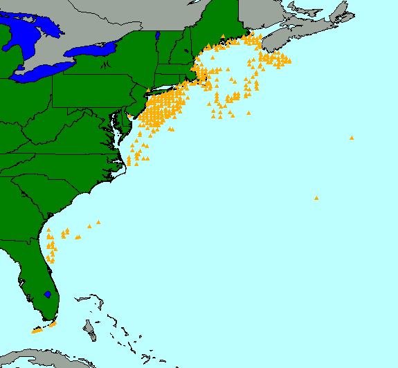
Location
of Bottom Photographs
|
|
location of bottom photographs taken along the U.S. Atlantic east coast as part of the
Continental Margin Program
|
Metadata:
- Identification_Information:
-
- Citation:
-
- Citation_Information:
-
- Originator: Valerie Paskevich(comp.)
- Publication_Date: 20010702
- Title:
-
location of bottom photographs taken along the U.S. Atlantic east coast as part of the Continental Margin Program
- Publication_Information:
-
- Publication_Place: Woods Hole Field Center, Woods Hole, MA
- Publisher: USGS, Coastal and Marine Geology Program
- Description:
-
- Abstract:
-
In 1962, Congress authorized the Continental Margin Program,
a joint program between the U.S. Geological Survey (USGS)
and the Woods Hole Oceanographic Institution (WHOI) to
conduct a geological reconnaissance investigation of the
continental shelf and slope off the Atlantic coast of the
United States. As part of this program 464 photographs
were collected at 378 stations from the Canadian border
to the southern tip of Florida. Bottom photography was
conducted at many of these stations in conjunction with
sediment sampling for grain size, mineralogy, geochemistry,
and biology. Those photographs have been scanned and are
archived here to release a digital version of the historical
dataset.
- Purpose:
-
This ArcView shapefile contains the locations
of bottom photographs taken along the U.S. Atlantic
East Coast as part of the Continental Margin Program
and may be utilized as a data layer in any Geographic
Information System (GIS).
- Supplemental_Information:
-
The bottom photographs in this gallery are especially
important because they can be used to appraise bottom
variability, faunal communities, and sedimentary processes
around stations distributed over a wide geographic area.
These photographs also document bedrock outcrops, boulder
fields, and coarse gravelly areas where statistically
meaningful samples could not be collected. It is precisely
because of this inability to collect adequate gravel
samples that this fraction is often under-represented in
many sediment grain-size databases (Hastings and others, 2000).
- Time_Period_of_Content:
-
- Time_Period_Information:
-
- Range_of_Dates/Times:
-
- Beginning_Date: 19630000
- Ending_Date: 19680000
- Currentness_Reference: completion of the Continental Margin Program sampling
- Status:
-
- Progress: Complete
- Maintenance_and_Update_Frequency: None planned
- Spatial_Domain:
-
- Bounding_Coordinates:
-
- West_Bounding_Coordinate: -81.8167
- East_Bounding_Coordinate: -59.9833
- North_Bounding_Coordinate: 44.8500
- South_Bounding_Coordinate: 24.4083
- Keywords:
-
- Theme:
-
- Theme_Keyword_Thesaurus: General
- Theme_Keyword: U.S. Geological Survey
- Theme_Keyword: Woods Hole Field Center
- Theme_Keyword: Continental Margin Program
- Theme_Keyword: bottom photographs
- Theme_Keyword: surficial sediments
- Theme_Keyword: seafloor photography
- Theme_Keyword: marine photography
- Theme_Keyword: black and white photography
- Place:
-
- Place_Keyword_Thesaurus: General
- Place_Keyword: North America
- Place_Keyword: continental United States
- Place_Keyword: east coast
- Place_Keyword: Atlantic Margin
- Place_Keyword: continental shelf
- Access_Constraints: None
- Use_Constraints:
-
The U.S. Geological Survey must be referenced as
the originator of the dataset in any future products
or research derived from these data.
Although this derived data set and it's lineage dataset
have been used by the USGS, no warranty, expressed
or implied, is made by the USGS as to the accuracy
of the data and/or related materials. The act of
distribution shall not constitute any such warranty, and
no responsibility is assumed by the USGS in the use
of these data or related materials.
- Point_of_Contact:
-
- Contact_Information:
-
- Contact_Organization_Primary:
-
- Contact_Organization: U. S. Geological Survey
- Contact_Person: Valerie Paskevich
- Contact_Position: Computer Specialist
- Contact_Address:
-
- Address_Type: mailing and physical address
- Address: 384 Woods Hole Road
- City: Woods Hole
- State_or_Province: MA
- Postal_Code: 02532
- Country: USA
- Contact_Voice_Telephone: (508) 548-8700 x2281
- Contact_Facsimile_Telephone: (508) 457-2310
- Contact_Electronic_Mail_Address: vpaskevich@usgs.gov
- Browse_Graphic:
-
- Browse_Graphic_File_Name: bphotos.gif
- Browse_Graphic_File_Description:
-
image showing location and distribution of bottom photographs along the U.S. East Coast
- Browse_Graphic_File_Type: GIF
- Data_Set_Credit:
-
This dataset is a subset of the surficial sediment
database held at the USGS, Coastal and Marine Geology
Program, Woods Hole Field Center.
- Native_Data_Set_Environment: ESRI ArcView shapefile
- Cross_Reference:
-
- Citation_Information:
-
- Originator: Larry Poppe(ed.)
- Originator: Chris Polloni(ed.)
- Publication_Date: 20000000
- Publication_Time: Unknown
- Title:
-
USGS East-coast Sediment Analysis: Procedures Database, and Georeferenced Displays
- Geospatial_Data_Presentation_Form: remote-sensing image
- Series_Information:
-
- Series_Name: Open-File Report
- Issue_Identification: 00-358
- Publication_Information:
-
- Publication_Place: Woods Hole Field Center, Woods Hole, MA
- Publisher: U.S. Geological Survey, Coastal and Marine Geology Program
- Online_Linkage: <http://woodshole.er.usgs.gov/cdroms/ofr00-358/>
- Data_Quality_Information:
-
- Logical_Consistency_Report: none
- Completeness_Report:
-
This data set is complete inasmuch as it contains
the location of those bottom photos that could be
recovered from the archives at the Woods Hole
Oceanographic Institution.
- Positional_Accuracy:
-
- Horizontal_Positional_Accuracy:
-
- Horizontal_Positional_Accuracy_Report:
-
Individuals should be careful when assuming precise
positional accuracy because of the navigational
equipment used to locate the bottom photography
stations. Most of the stations were navigated with Loran-A;
some near-shore stations were navigated by radar and
line of sight. As a general rule of thumb, Loran-A had an
average expected accuracy of 1 percent of the
distance between the navigator and the onshore Loran
stations (U.S. Coast Guard, 1949).
- Lineage:
-
- Source_Information:
-
- Source_Citation:
-
- Citation_Information:
-
- Originator: John C. Hathaway(comp.)
- Publication_Date: 19710000
- Publication_Time: Unknown
- Title:
-
DATA FILE: CONTINENTAL MARGIN PROGRAM ATLANTIC COAST OF THE UNITED STATES
- Edition: Vol. 2 Samples Collection and Analystical Data
- Publication_Information:
-
- Publication_Place: Woods Hole, MA
- Publisher: Woods Hole Oceangraphic Institution
- Larger_Work_Citation:
-
- Citation_Information:
-
- Originator: L.J. Poppe(ed.)
- Originator: C.F. Polloni(ed.)
- Publication_Date: 20000000
- Title:
-
U.S. Geological Survey East-Coast Sediment Analysis: Procedures, Database, and Georeferenced Displays
- Edition: Vol. 2 Samples Collection and Analystical Data
- Series_Information:
-
- Series_Name: Open-File Report
- Issue_Identification: 00-358
- Publication_Information:
-
- Publication_Place: Woods Hole, MA
- Publisher: USGS, Coastal and Marine Geology Program
- Online_Linkage: <http://woodshole.er.usgs.gov/cdroms/ofr00-358>
- Type_of_Source_Media: disk file
- Source_Time_Period_of_Content:
-
- Time_Period_Information:
-
- Range_of_Dates/Times:
-
- Beginning_Date: 19630000
- Ending_Date: 19710000
- Source_Currentness_Reference: Publication Date
- Source_Citation_Abbreviation: sd022395.db
- Source_Contribution:
-
Data from report 71-15 were digitally transcribed to create
a Paradox database. This database was the foundation of
the USGS East Coast Sediment Texture database referenced as
the Larger_Work_Citation in the Source_Information.
- Process_Step:
-
- Process_Description:
-
The records pertaining to the bottom photos
were extracted from the sediment database.
- Source_Used_Citation_Abbreviation: sd022395.db
- Process_Date: 20010305
- Source_Produced_Citation_Abbreviation: stations.xls
- Process_Contact:
-
- Contact_Information:
-
- Contact_Organization_Primary:
-
- Contact_Organization: U. S. Geological Survey
- Contact_Person: M.E. (Polly) Hastings
- Contact_Position: database specialist
- Contact_Address:
-
- Address_Type: mailing and physical address
- Address: 384 Woods Hole Road
- City: Woods Hole
- State_or_Province: MA
- Postal_Code: 02543
- Country: USA
- Contact_Voice_Telephone: (508) 548-8700 x2289
- Contact_Facsimile_Telephone: (508) 457-2310
- Contact_Electronic_Mail_Address: phastings@usgs.gov
- Process_Step:
-
- Process_Description:
-
The Excel spreadsheet was exported as an ASCII text file
with tab delimited fields.
- Source_Used_Citation_Abbreviation: stations.xls
- Process_Date: 20010515
- Source_Produced_Citation_Abbreviation: stations.txt
- Process_Contact:
-
- Contact_Information:
-
- Contact_Organization_Primary:
-
- Contact_Organization: U. S. Geological Survey
- Contact_Person: Valerie Paskevich
- Contact_Position: Computer Specialist
- Contact_Address:
-
- Address_Type: mailing and physical address
- Address: 384 Woods Hole Road
- City: Woods Hole
- State_or_Province: MA
- Postal_Code: 02543
- Country: USA
- Contact_Voice_Telephone: (508) 548-8700 x2281
- Contact_Facsimile_Telephone: (508) 457-2310
- Contact_Electronic_Mail_Address: vpaskevich@usgs.gov
- Process_Step:
-
- Process_Description:
-
The file, stations.txt, was imported into ArcView to create
a table. The table was then converted to an ArcView shapefile
to be used as a GIS data layer. Also, at this time the
ArcView legend file, bphotos.avl, was created and saved.
- Source_Used_Citation_Abbreviation: stations.txt
- Process_Date: 20010608
- Source_Produced_Citation_Abbreviation: bphotos.dbf
- Source_Produced_Citation_Abbreviation: bphotos.shp
- Source_Produced_Citation_Abbreviation: bphotos.shx
- Source_Produced_Citation_Abbreviation: bphotos.sbn
- Source_Produced_Citation_Abbreviation: bphotos.sbx
- Source_Produced_Citation_Abbreviation: bphotos.avl
- Process_Contact:
-
- Contact_Information:
-
- Contact_Organization_Primary:
-
- Contact_Organization: U. S. Geological Survey
- Contact_Person: Valerie Paskevich
- Contact_Position: Computer Specialist
- Contact_Address:
-
- Address_Type: mailing and physical address
- Address: 384 Woods Hole Road
- City: Woods Hole
- State_or_Province: MA
- Postal_Code: 02543
- Country: USA
- Contact_Voice_Telephone: (508) 548-8700 x2281
- Contact_Facsimile_Telephone: (508) 457-2310
- Contact_Electronic_Mail_Address: vpaskevich@usgs.gov
- Process_Step:
-
- Process_Description:
-
The ArcView shapefile was modified to add the field URL.
This new field holds the relative path to the HTML formatted
page containing the bottom photograph associated with the
FIELD_ID for the data record.
- Source_Used_Citation_Abbreviation: bphotos.dbf
- Process_Date: 20010608
- Source_Produced_Citation_Abbreviation: bphotos.dbf
- Process_Contact:
-
- Contact_Information:
-
- Contact_Organization_Primary:
-
- Contact_Organization: U. S. Geological Survey
- Contact_Person: Valerie Paskevich
- Contact_Position: Computer Specialist
- Contact_Address:
-
- Address_Type: mailing and physical address
- Address: 384 Woods Hole Road
- City: Woods Hole
- State_or_Province: MA
- Postal_Code: 02543
- Country: USA
- Contact_Voice_Telephone: (508) 548-8700 x2281
- Contact_Facsimile_Telephone: (508) 457-2310
- Contact_Electronic_Mail_Address: vpaskevich@usgs.gov
- Spatial_Data_Organization_Information:
-
- Direct_Spatial_Reference_Method: Point
- Point_and_Vector_Object_Information:
-
- SDTS_Terms_Description:
-
- SDTS_Point_and_Vector_Object_Type: Point
- Point_and_Vector_Object_Count: 378
- Spatial_Reference_Information:
-
- Horizontal_Coordinate_System_Definition:
-
- Geographic:
-
- Latitude_Resolution: .17
- Longitude_Resolution: .24
- Geographic_Coordinate_Units: Decimal degrees
- Geodetic_Model:
-
- Horizontal_Datum_Name: North American Datum of 1927
- Ellipsoid_Name: Clarke 1866
- Semi-major_Axis: 6378206.4
- Denominator_of_Flattening_Ratio: 294.98
- Entity_and_Attribute_Information:
-
- Detailed_Description:
-
- Entity_Type:
-
- Entity_Type_Label: bphotos.dbf
- Entity_Type_Definition: Shapefile Attribute Table
- Entity_Type_Definition_Source: None
- Attribute:
-
- Attribute_Label: Field_id
- Attribute_Definition:
-
Field identifier - sample name or number as assigned in
the field.
- Attribute_Definition_Source: User Defined
- Attribute_Domain_Values:
-
- Unrepresentable_Domain: Character field
- Attribute:
-
- Attribute_Label: Area
- Attribute_Definition:
-
General geographic area to identify location of
bottom photograph. The "area" is general enough
to easily locate the area on a map.
- Attribute_Definition_Source: Software computed
- Attribute_Domain_Values:
-
- Unrepresentable_Domain: Character field
- Attribute:
-
- Attribute_Label: Latitude
- Attribute_Definition:
-
Latitude coordinate portion of position of bottom
photo location. Value is recorded in decimal-degrees.
South latitudes are recorded as negative values.
- Attribute_Definition_Source: User Defined
- Attribute_Domain_Values:
-
- Range_Domain:
-
- Range_Domain_Minimum: 24.4083
- Range_Domain_Maximum: 44.8500
- Attribute_Units_of_Measure: signed decimal degrees
- Attribute:
-
- Attribute_Label: Longitude
- Attribute_Definition:
-
Longitude coordinate portion of position of bottom
photo location. Value is recorded in decimal-degrees.
West longitudes are recorded as negative values.
- Attribute_Definition_Source: User Defined
- Attribute_Domain_Values:
-
- Range_Domain:
-
- Range_Domain_Minimum: -81.8167
- Range_Domain_Maximum: -59.9833
- Attribute_Units_of_Measure: signed decimal degrees
- Attribute:
-
- Attribute_Label: Depth_m
- Attribute_Definition:
-
Depth or sounding in meters - Measured depth of
water, in meters, overlying sediment at sample time.
Depth value is not corrected for tides.
- Attribute_Definition_Source: User Defined
- Attribute_Domain_Values:
-
- Range_Domain:
-
- Range_Domain_Minimum: 7
- Range_Domain_Maximum: 4861
- Attribute_Units_of_Measure: meters
- Attribute:
-
- Attribute_Label: Cruise_id
- Attribute_Definition:
-
Cruise ID - Name or number of cruise on which sample
collected
- Attribute_Definition_Source: User Defined
- Attribute_Domain_Values:
-
- Unrepresentable_Domain: Character field
- Attribute:
-
- Attribute_Label: Device
- Attribute_Definition: Sampling device - Device used to collect the sample
- Attribute_Definition_Source: User Defined
- Attribute_Domain_Values:
-
- Unrepresentable_Domain: Character field
- Attribute:
-
- Attribute_Label: Lithology
- Attribute_Definition: Lithology - general lithologic description of sample
- Attribute_Definition_Source: User Defined
- Attribute_Domain_Values:
-
- Unrepresentable_Domain: Character field
- Attribute:
-
- Attribute_Label: No_photos
- Attribute_Definition: number of photos taken at station
- Attribute_Definition_Source: User Defined
- Attribute_Domain_Values:
-
- Range_Domain:
-
- Range_Domain_Minimum: 1
- Range_Domain_Maximum: 6
- Attribute_Units_of_Measure: integer value
- Attribute:
-
- Attribute_Label: URL
- Attribute_Definition:
-
URL (Uniform Resource Locator) link to HTML formatted
page containing thumbnail(s) view of the bottom
photograph for the given station. The HTML formatted
page also includes links to a larger, browse image
and the full-resolution bottom photograph.
- Attribute_Definition_Source: User Defined
- Attribute_Domain_Values:
-
- Unrepresentable_Domain: Character field
- Distribution_Information:
-
- Distributor:
-
- Contact_Information:
-
- Contact_Organization_Primary:
-
- Contact_Organization: U. S. Geological Survey
- Contact_Person: Valerie Paskevich
- Contact_Position: Computer Specialist
- Contact_Address:
-
- Address_Type: mailing and physical address
- Address: 384 Woods Hole Road
- City: Woods Hole
- State_or_Province: MA
- Postal_Code: 02543
- Country: USA
- Contact_Voice_Telephone: (508) 548-8700 x2281
- Contact_Facsimile_Telephone: (508) 457-2310
- Contact_Electronic_Mail_Address: vpaskevich@usgs.gov
- Resource_Description:
-
ArcView shapefile of bottom photographs taken along the U.S. Atlantic East Coast as part of the Continental Margin Project
- Distribution_Liability:
-
Although this derived data set and it's lineage dataset
have been used by the USGS, no warranty, expressed
or implied, is made by the USGS as to the accuracy
of the data and/or related materials. The act of
distribution shall not constitute any such warranty, and
no responsibility is assumed by the USGS in the use
of these data or related materials.
- Standard_Order_Process:
-
- Digital_Form:
-
- Digital_Transfer_Information:
-
- Format_Name: ARCV
- Format_Information_Content:
-
bphotos.avl
bphotos.dbf
bphotos.sbn
bphotos.sbx
bphotos.shp
bphotos.shx
- File_Decompression_Technique: No compression applied
- Transfer_Size: 106,443Kb
- Digital_Transfer_Option:
-
- Offline_Option:
-
- Offline_Media: CD-ROM
- Recording_Capacity:
-
- Recording_Density: 650
- Recording_Density_Units: Mbytes
- Recording_Format: ISO 9600
- Compatibility_Information:
-
The user must have a system with a CD-ROM capable of
reading an ISO-9660 standard CD-ROM disk. To browse
the information contained on this disk, the user must also
have a current version of WWW browser available.
- Digital_Form:
-
- Digital_Transfer_Information:
-
- Format_Name: ARCV
- Format_Information_Content:
-
The six files comprising the ArcView shapefile representing
the Continental Margin bottom photograph locations.
- File_Decompression_Technique: zip
- Transfer_Size: 23Kb
- Digital_Transfer_Option:
-
- Offline_Option:
-
- Offline_Media: CD-ROM
- Recording_Capacity:
-
- Recording_Density: 650
- Recording_Density_Units: Mbytes
- Recording_Format: ISO 9600
- Compatibility_Information:
-
The user must have a system with a CD-ROM capable of
reading an ISO-9660 standard CD-ROM disk. To browse
the information contained on this disk, the user must also
have a current version of WWW browser available.
- Fees: none
- Technical_Prerequisites:
-
The Continental Margin bottom photograph locations overlay
is available as an ArcView shapefile format. The user must
have ESRI's ArcView 3.0 or greater software to read and
process the data file. In lieu of Arcview, the user may
utilize another GIS application package capable of importing
the data.
Access to the data and information contained on this
CD-ROM was developed using the HyperText Markup
Language (HTML) utilized by the World Wide Web
(WWW) project. Development of the CD-ROM
documentation and user interface in HTML allows a user
to access the information by using a variety of
WWW information browsers to facilitate browsing and
locating information and data. To access the information
contained on this disk with a WWW client browser, open
the file 'index.htm' at the top level directory of this CD-ROM
with your selected browser.
This CD-ROM should be readable by a variety of
operating systems including Windows 95/98/NT,
Macintosh and UNIX.
- Metadata_Reference_Information:
-
- Metadata_Date: 20010704
- Metadata_Contact:
-
- Contact_Information:
-
- Contact_Organization_Primary:
-
- Contact_Organization: U. S. Geological Survey
- Contact_Person: Valerie Paskevich
- Contact_Position: Computer Specialist
- Contact_Address:
-
- Address_Type: mailing and physical address
- Address: 384 Woods Hole Rd.
- City: Woods Hole
- State_or_Province: MA
- Postal_Code: 02543
- Country: USA
- Contact_Voice_Telephone: (508) 5488700 x2281
- Contact_Facsimile_Telephone: (508) 457-2310
- Contact_Electronic_Mail_Address: vpaskevich@usgs.gov
- Metadata_Standard_Name: FGDC Content Standards for Digital Geospatial Metadata
- Metadata_Standard_Version: FGDC-STD-001-1998
- Metadata_Time_Convention: Local time
- Metadata_Access_Constraints: None
- Metadata_Use_Constraints: None
Generated by
mp version 2.5.3 on Wed Jul 04 08:19:01 2001