USGS home - www.usgs.gov
Coastal and Marine Geology Program homepage - marine.usgs.gov

  U. S. Geological Survey Open-File Report 01-154


thumbnail view of 2-min color relief image of U.S. Atlantic East Coast
Shaded Relief Image

2 min color relief image of U.S. Atlantic East Coast

Metadata:


Identification_Information:
Citation:
Citation_Information:
Originator: Valerie Paskevich(comp.)
Publication_Date: 20010305
Title: 2 min color relief image of North America
Other_Citation_Details:
This image is a composite from a series of images created by the National Geophysical Data Center (NGDC) in Boulder, CO.
Description:
Abstract:
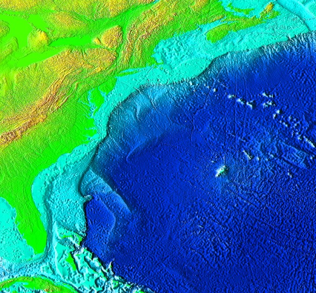
This composite mosaic is a 2minute color relief image North America. Six individual mosaics were combined to create the overview. The images, created by NOAA/NGDC combines topography and bathymetry from a variety sources. The data were gridded and processed to create a 45 deg illuminated shaded relief image. The image was then color coded to enhance the bathymetry/topography range.
Purpose:
This image may be used as a basemap layer in various GIS projects.
Supplemental_Information:
This supplemental information was extracted from the NGDC/NOAA, MGG website.
 
This image was generated from digital data bases of seafloor and land elevations on a 2-minute latitude/longitude grid (1 minute of latitude equals 1 nautical mile, or 1.852 km). Assumed illumination is from the west; shading is computed as a function of the east-west slope of the surface with a nonlinear exaggeration favoring low-relief areas. A Cylindrical Equidistant projection was used for the world image, which spans 360 degrees of longitude from 180 West eastward to 180 East; latitude coverage is from 90 degrees North to 90 degrees South. The resolution of the gridded data varies from true 2-minute for the Atlantic, Pacific, and Indian Ocean floors and all land masses to 5 minutes for the Arctic Ocean floor. 
Time_Period_of_Content:
Time_Period_Information:
Single_Date/Time:
Calendar_Date: 20010305
Currentness_Reference: creation of composite mosaic
Status:
Progress: Complete
Maintenance_and_Update_Frequency: None planned
Spatial_Domain:
Bounding_Coordinates:
West_Bounding_Coordinate: -84.13334722
East_Bounding_Coordinate: -56.66668333
North_Bounding_Coordinate: 47.23333889
South_Bounding_Coordinate: 21.73333889
Keywords:
Theme:
Theme_Keyword_Thesaurus: General
Theme_Keyword: National Oceanic and Atmospheric Administration
Theme_Keyword: NOAA
Theme_Keyword: National Geophysical Data Center
Theme_Keyword: NGDC
Theme_Keyword: Marine Geology and Geophysics
Theme_Keyword: MGG
Theme_Keyword: U.S. Geological Survey
Theme_Keyword: Woods Hole Field Center
Theme_Keyword: basemap
Theme_Keyword: image
Theme_Keyword: color shaded relief
Theme_Keyword: earth surface
Theme_Keyword: topography
Theme_Keyword: bathymetry
Theme_Keyword: globe view
Theme_Keyword: global relief
Theme_Keyword: GEOTIFF
Place:
Place_Keyword_Thesaurus: General
Place_Keyword: North America
Place_Keyword: continental United States
Place_Keyword: east coast
Place_Keyword: Canada
Place_Keyword: Cuba
Place_Keyword: Caribbean
Access_Constraints: None
Use_Constraints:
No detailed use constraints for this data set could be found at the NOAA/NGDC site. 
 
Although this derived data set and it's lineage dataset have been used by the USGS, no warranty, expressed or implied, is made by the USGS as to the accuracy of the data and/or related materials. The act of distribution shall not constitute any such warranty, and no responsibility is assumed by the USGS in the use of these data or related materials.
Point_of_Contact:
Contact_Information:
Contact_Organization_Primary:
Contact_Organization: U. S. Geological Survey
Contact_Person: Valerie Paskevich
Contact_Position: Computer Specialist
Contact_Address:
Address_Type: mailing and physical address
Address: 384 Woods Hole Road
City: Woods Hole
State_or_Province: MA
Postal_Code: 02532
Country: USA
Contact_Voice_Telephone: (508) 548-8700 x2281
Contact_Facsimile_Telephone: (508) 457-2310
Contact_Electronic_Mail_Address: vpaskevich@usgs.gov
Browse_Graphic:
Browse_Graphic_File_Name: topo.jpg 
Browse_Graphic_File_Description: US East Coast shaded relief image for project view 
Browse_Graphic_File_Type: JPEG
Data_Set_Credit:
Data were compiled and the images were created by Dr. Peter Sloss, NOAA/NGDC, Boulder CO. Data for the individual images were compiled from a number of sources. For detailed information, please see www.ngdc.noaa.gov/mgg/image/2minrelief.html
Native_Data_Set_Environment: GEOTIFF format 3.0
Cross_Reference:
Citation_Information:
Originator: Dr. Peter Sloss(comp.)
Publication_Date: Unknown
Publication_Time: Unknown
Title: Surface of the Earth, 2 minute color relief images
Geospatial_Data_Presentation_Form: remote-sensing image
Publication_Information:
Publication_Place: Boulder, CO
Publisher:
NOAA, National Geophysical Data Center, World Data Center, Marine Geology & Geophysics
Online_Linkage: <http://www.ngdc.noaa.gov/mgg/image/2minrelief.html>

Data_Quality_Information:
Logical_Consistency_Report: none
Completeness_Report:
The image is complete in as much as it covers the desired area of interest. It should be noted, however, that this image is a subset of the data set available from NOAA/NGDC.
Lineage:
Source_Information:
Source_Citation:
Citation_Information:
Originator: Dr. Peter Sloss(comp.)
Publication_Date: Unknown
Publication_Time: Unknown
Title: Surface of the Earth, 2 minute color relief images
Geospatial_Data_Presentation_Form: remote-sensing image
Publication_Information:
Publication_Place: Boulder, CO
Publisher:
NOAA, National Geophysical Data Center, World Data Center, Marine Geology & Geophysics
Online_Linkage: <www.ngdc.noaa.gov/mgg/image/2minrelief.html>
Type_of_Source_Media: remote sensing image
Source_Time_Period_of_Content:
Time_Period_Information:
Single_Date/Time:
Calendar_Date: 1997
Source_Currentness_Reference: Reference Date
Source_Citation_Abbreviation: <www.ngdc.noaa.gov/mgg/image/2minrelief.html>
Source_Contribution:
Six of the available 32 mosaics were combined to create a North America overview.
Process_Step:
Process_Description:
The six desired images were downloaded from the NOAA/NGDC website. The 2 min gridded images were 1350 pixels by 1350 lines.
Source_Used_Citation_Abbreviation: <http://www.ngdc.noaa.gov/mgg/image/2minsurface/45N090W.html>
Source_Used_Citation_Abbreviation: <http://www.ngdc.noaa.gov/mgg/image/2minsurface/45N135W.html>
Source_Used_Citation_Abbreviation: <http://www.ngdc.noaa.gov/mgg/image/2minsurface/45N180W.html>
Source_Used_Citation_Abbreviation: <http://www.ngdc.noaa.gov/mgg/image/2minsurface/90N090W.html>
Source_Used_Citation_Abbreviation: <http://www.ngdc.noaa.gov/mgg/image/2minsurface/90N135W.html>
Source_Used_Citation_Abbreviation: <http://www.ngdc.noaa.gov/mgg/image/2minsurface/90N180W.html>
Process_Date: 20010305
Source_Produced_Citation_Abbreviation: 45n090w.jpg
Source_Produced_Citation_Abbreviation: 45n135w.jpg
Source_Produced_Citation_Abbreviation: 45n180w.jpg
Source_Produced_Citation_Abbreviation: 90n090w.jpg
Source_Produced_Citation_Abbreviation: 90n135w.jpg
Source_Produced_Citation_Abbreviation: 90n180w.jpg
Process_Contact:
Contact_Information:
Contact_Organization_Primary:
Contact_Organization: U. S. Geological Survey
Contact_Person: Valerie Paskevich
Contact_Position: Computer Specialist
Contact_Address:
Address_Type: mailing and physical address
Address: 384 Woods Hole Road
City: Woods Hole
State_or_Province: MA
Postal_Code: 02543
Country: USA
Contact_Voice_Telephone: (508) 548-8700 x2281
Contact_Facsimile_Telephone: (508) 457-2310
Contact_Electronic_Mail_Address: vpaskevich@usgs.gov
Process_Step:
Process_Description:
Each of the individual images were compiled in a separate PCI image data base. The individual images were then georeferenced according to their upper left and lower right coordinates and 2 min (.0333334 deg) data resolution.
Source_Used_Citation_Abbreviation: 45n090w.jpg
Source_Used_Citation_Abbreviation: 45n135w.jpg
Source_Used_Citation_Abbreviation: 45n180w.jpg
Source_Used_Citation_Abbreviation: 90n090w.jpg
Source_Used_Citation_Abbreviation: 90n135w.jpg
Source_Used_Citation_Abbreviation: 90n180w.jpg
Process_Date: 20010305
Source_Produced_Citation_Abbreviation: 45n090w.pix
Source_Produced_Citation_Abbreviation: 45n135w.pix
Source_Produced_Citation_Abbreviation: 45n180w.pix
Source_Produced_Citation_Abbreviation: 90n090w.pix
Source_Produced_Citation_Abbreviation: 90n135w.pix
Source_Produced_Citation_Abbreviation: 90n180w.pix
Process_Contact:
Contact_Information:
Contact_Organization_Primary:
Contact_Organization: U. S. Geological Survey
Contact_Person: Valerie Paskevich
Contact_Position: Computer Specialist
Contact_Address:
Address_Type: mailing and physical address
Address: 384 Woods Hole Road
City: Woods Hole
State_or_Province: MA
Postal_Code: 02543
Country: USA
Contact_Voice_Telephone: (508) 548-8700 x2281
Contact_Facsimile_Telephone: (508) 457-2310
Contact_Electronic_Mail_Address: vpaskevich@usgs.gov
Process_Step:
Process_Description:
A new composite image to hold the six individual images was created and the individual images were mosaicked using PCI program GCPworks.
Source_Used_Citation_Abbreviation: 45n090w.pix
Source_Used_Citation_Abbreviation: 45n135w.pix
Source_Used_Citation_Abbreviation: 45n180w.pix
Source_Used_Citation_Abbreviation: 90n090w.pix
Source_Used_Citation_Abbreviation: 90n135w.pix
Source_Used_Citation_Abbreviation: 90n180w.pix
Process_Date: 20010305
Source_Produced_Citation_Abbreviation: compos.pix
Process_Contact:
Contact_Information:
Contact_Organization_Primary:
Contact_Organization: U. S. Geological Survey
Contact_Person: Valerie Paskevich
Contact_Position: Computer Specialist
Contact_Address:
Address_Type: mailing and physical address
Address: 384 Woods Hole Road
City: Woods Hole
State_or_Province: MA
Postal_Code: 02543
Country: USA
Contact_Voice_Telephone: (508) 548-8700 x2281
Contact_Facsimile_Telephone: (508) 457-2310
Contact_Electronic_Mail_Address: vpaskevich@usgs.gov
Process_Step:
Process_Description:
A subset of the US composite image was extracted for the project area of interest and output as a GEOTIFF image with a world file.
Source_Used_Citation_Abbreviation: compos.pix
Process_Date: 20010606
Source_Produced_Citation_Abbreviation: topo.tif
Process_Contact:
Contact_Information:
Contact_Organization_Primary:
Contact_Organization: U. S. Geological Survey
Contact_Person: Valerie Paskevich
Contact_Position: Computer Specialist
Contact_Address:
Address_Type: mailing and physical address
Address: 384 Woods Hole Road
City: Woods Hole
State_or_Province: MA
Postal_Code: 02543
Country: USA
Contact_Voice_Telephone: (508) 548-8700 x2281
Contact_Facsimile_Telephone: (508) 457-2310
Contact_Electronic_Mail_Address: vpaskevich@usgs.gov

Spatial_Data_Organization_Information:

Spatial_Reference_Information:
Horizontal_Coordinate_System_Definition:
Geographic:
Latitude_Resolution: .0333334
Longitude_Resolution: .0333334
Geographic_Coordinate_Units: Decimal degrees

Distribution_Information:
Distributor:
Contact_Information:
Contact_Organization_Primary:
Contact_Organization: U. S. Geological Survey
Contact_Person: Valerie Paskevich
Contact_Position: Computer Specialist
Contact_Address:
Address_Type: mailing and physical address
Address: 384 Woods Hole Road
City: Woods Hole
State_or_Province: MA
Postal_Code: 02543
Country: USA
Contact_Voice_Telephone: (508) 548-8700 x2281
Contact_Facsimile_Telephone: (508) 457-2310
Contact_Electronic_Mail_Address: vpaskevich@usgs.gov
Resource_Description:
North America 2 deg shaded relief image: topography and bathymetry
Distribution_Liability:
Although this derived data set and it's lineage dataset have been used by the USGS, no warranty, expressed or implied, is made by the USGS as to the accuracy of the data and/or related materials. The act of distribution shall not constitute any such warranty, and no responsibility is assumed by the USGS in the use of these data or related materials.
Standard_Order_Process:
Digital_Form:
Digital_Transfer_Information:
Format_Name: TIFF
File_Decompression_Technique: No compression applied
Transfer_Size: 1848Kb
Digital_Transfer_Option:
Offline_Option:
Offline_Media: CD-ROM
Recording_Capacity:
Recording_Density: 650
Recording_Density_Units: Mbytes
Recording_Format: ISO 9600
Compatibility_Information:
The user must have a system with a CD-ROM capable of reading an ISO-9660 standard CD-ROM disk. To browse the information contained on this disk, the user must also have a current version of WWW browser available.
Digital_Form:
Digital_Transfer_Information:
Format_Name: ARCE
Format_Information_Content:
The GEOTIFF image, world file and georeference report has been archived together in this zip format file.
File_Decompression_Technique: zip
Transfer_Size: 243Kb
Digital_Transfer_Option:
Offline_Option:
Offline_Media: CD-ROM
Recording_Capacity:
Recording_Density: 650
Recording_Density_Units: Mbytes
Recording_Format: ISO 9600
Compatibility_Information:
The user must have a system with a CD-ROM capable of reading an ISO-9660 standard CD-ROM disk. To browse the information contained on this disk, the user must also have a current version of WWW browser available.
Fees: none
Technical_Prerequisites:
Access to the data and information contained on this CD-ROM was developed using the HyperText Markup Language (HTML) utilized by the World Wide Web (WWW) project. Development of the CD-ROM documentation and user interface in HTML allows a user to access the information by using a variety of WWW information browsers to facilitate browsing and locating information and data. To access the information contained on this disk with a WWW client browser, open the file 'index.htm' at the top level directory of this CD-ROM with your selected browser. This CD-ROM should be readable by a variety of operating systems including Windows 95/98/NT, Macintosh and UNIX.

Metadata_Reference_Information:
Metadata_Date: 20010701
Metadata_Contact:
Contact_Information:
Contact_Organization_Primary:
Contact_Organization: U. S. Geological Survey
Contact_Person: Valerie Paskevich
Contact_Position: Computer Specialist
Contact_Address:
Address_Type: mailing and physical address
Address: 384 Woods Hole Rd.
City: Woods Hole
State_or_Province: MA
Postal_Code: 02543
Country: USA
Contact_Voice_Telephone: (508) 5488700 x2281
Contact_Facsimile_Telephone: (508) 457-2310
Contact_Electronic_Mail_Address: vpaskevich@usgs.gov
Metadata_Standard_Name: FGDC Content Standards for Digital Geospatial Metadata
Metadata_Standard_Version: FGDC-STD-001-1998
Metadata_Time_Convention: Local time
Metadata_Access_Constraints: None
Metadata_Use_Constraints: None

Generated by mp version 2.5.3 on Sun Jul 01 11:34:29 2001