![]()
U.S. Geological Survey Open-File Report 01-178
Resources on Federal Lands for Five Coal Beds in the Northern and Central Appalachian Basin Coal Regions
By Susan J. Tewalt
This report is
preliminary and has not been reviewed for conformity with U.S. Geological Survey
editorial standards. Any use of trade, product, or firm names is for descriptive
purposes only and does not imply endorsement by the U.S. Government.
The Appalachian Basin is one of the most important coal-producing regions in the United States. The U.S. Geological Survey (USGS) recently assessed five coal-bearing regions, including the Appalachian Basin (Northern and Central Appalachian Basin Coal Regions Assessment Team, in press). The USGS coal resource assessments have produced digital coal maps and databases, or models, which characterize the coal beds and coal zones that will provide the bulk of U.S. production for the next several decades. The assessments were designed to provide geoscientists, policy makers, planners, and the public with concise geologic information on the quantity and quality of remaining coal resources.
The Appalachian basin has historically been subdivided into three coal regions based on regional geologic structure and stratigraphy: the northern region in western Pennsylvania, eastern Ohio, western Maryland, and northern West Virginia; the central region in west-central and southwestern West Virginia, eastern Kentucky, northern Tennessee, and southwestern Virginia; and the southern region in southern Tennessee, northern Alabama and northwestern Georgia. Only coal beds, coal zones, and coal production in the northern and central Appalachian Basin coal regions were evaluated, because less than 5 percent of the Appalachian Basin production has occurred in the southern coal region.
Appalachian Basin assessments calculated resources (coal greater than 14 inches thick) for top-producing coals in cooperation with State geological surveys. The West Virginia Geological and Economic Survey (WVGES), the Pennsylvania Bureau of Topographic and Geologic Survey, the Ohio Department of Natural Resources, Division of Geological Survey, and the Maryland Geological Survey partnered with the USGS in the assessments of the Pittsburgh, Upper Freeport, and Lower Kittanning coal beds (fig. 1). The Pond Creek and Fire Clay coal-zone assessments (fig. 1) were conducted with the aid of the Kentucky Geological Survey, the Virginia Division of Mineral Resources (VDMR), and the WVGES. The VDMR and the WVGES worked with the USGS to assess the Pocahontas No. 3 coal bed (fig. 1). From the assessment models, original and remaining resources were estimated for these coals with the exception of the Lower Kittanning coal bed (Northern and Central Appalachian Basin Coal Regions Assessment Team, in press; fig. 1).
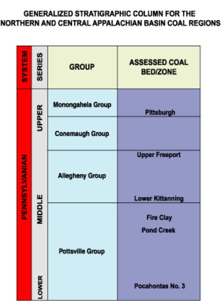
Figure 1. Stratigraphic column showing the assessed coal beds and zones in the northern and central Appalachian Basin coal regions.
In the western U.S., Federal lands are extensive in the coal-bearing regions. Kirschbaum and others (2000) report for the Colorado Plateau region that six of the coal assessment units had from 25 to 99 percent of their total areas in Federal surface ownership. Federal surface lands along the eastern U.S. seaboard include national forests, U.S. military properties, Tribal land, national parks, water bodies and other recreational areas and monuments (fig. 2). Within the Appalachian Basin, Federal surface ownership in four assessed coals (Pittsburgh, Upper Freeport, Pond Creek, and Pocahontas No. 3) is under 5 percent of their total resource areas (fig. 3). The Fire Clay coal has 15 percent of its area in Federal surface ownership (fig. 3).
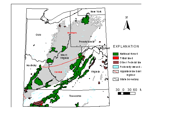
Figure 2. Map showing distribution of Federal lands and the extent of coal-bearing rocks in the northern and central Appalachian basin coal regions. Note that the majority of Federal land is national forest.
Ownership of mineral rights, including but not necessarily limited to coal, is not implied by the ownership of surface rights, even on Federal lands. The amount of federally owned coal is in a state of flux on eastern Federal lands. Land is obtained, rights are acquired or reverted back to the government through time. This report summarizes total current remaining coal resources underlying Federal surface lands by State for five coal beds that were digitally assessed in the Appalachian Basin (Northern and Central Appalachian Basin Coal Regions Assessment Team, in press). The reported tonnage represents coal underlying land with Federal surface ownership. The actual amount of coal tonnage that is federally owned cannot be determined without specific knowledge of subsurface mineral rights ownership.
Geographic information system (GIS) coverages of coal extent and thickness, overburden thickness, and political boundaries were created for each of the five coal beds for the Appalachian Basin NCRA (Northern and Central Appalachian Basin Coal Regions Assessment Team, in press). These coverages were combined in Arc/Info (ESRI, 1999) and tonnage calculated for original (in-the-ground) resources. Remaining resources (unmined coal) were also estimated by compiling available areas of mining from multiple published sources. Tonnage was calculated in the five assessed coal coverages by multiplying coal thickness, area, and a density conversion factor for bituminous coal. The five resource coverages were intersected in Arc/Info with a USGS coverage of Federal surface land proclamation areas (http://www.nationalatlas.gov). Results of the intersections of coal extent and Federal surface lands are shown in blue on figure 3 for the five assessed coals. Table 1 presents sums for remaining resources within the Federal land areas, by State for each coal bed.
Table 1. Remaining resources (in millions of short tons with two significant figures) underlying Federal surface ownership proclamation land areas, but not necessarily having Federal mineral ownership. NP = coal not present in the State
|
|
|
|
|
|
|
|
|
|
Coal
name |
Ohio |
Pennsylvania |
West
Virginia |
Maryland |
Virginia |
Kentucky |
Totals |
|
|
|
|
|
|
|
|
|
|
Pittsburgh |
860 |
0 |
0 |
0 |
NP |
NP |
860 |
|
Upper
Freeport |
4,400 |
701 |
310 |
44 |
NP |
NP |
5,500 |
|
Fire
Clay |
NP |
NP |
0 |
NP |
42 |
1,060 |
1.100 |
|
Pond
Creek |
NP |
NP |
10 |
NP |
250 |
310 |
570 |
|
Pocahontas
No. 3 |
NP |
NP |
250 |
NP |
100 |
NP |
350 |
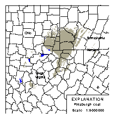
Figure 3. Location of known
resource areas for assessed coal beds or coal zones (Northern and Central
Appalachian Basin Coal Regions Assessment Team, in press) and specific areas
with Federal land surface ownership. Note that maps are at different scales.
Although remaining tonnage for the five Appalachian coals under Federal lands totals roughly 8,300 million short tons, this coal is not necessarily available for mining or economically feasible to mine. The distribution of ownership parcels and existence of surface and technological restrictions on the minability of these coals could eliminate a large part of the resource.
Surface-mined areas for the Pittsburgh coal in the NCRA assessment coverages are not up-to-date in Ohio, so the amount of remaining coal indicated on Federal lands is probably overestimated. The Upper Freeport coal bed appears to have substantial remaining resources under Ohio Federal lands (about 36 percent of the bedÕs total remaining resources in Ohio). Likewise the Fire Clay coal zone appears to have substantial remaining resources under Federal lands in Kentucky (about 33 percent of the bedÕs total remaining resources in the State). Remaining resources of the Fire Clay coal zone and the other beds are known to be thinner and deeper than parts that have already been mined (Northern and Central Appalachian Basin Coal Regions Assessment Team, in press). About 86 percent of the remaining Fire Clay resources in Virginia are under Federal lands, as well as nearly 68 percent of the remaining Pond Creek coal zone resource in that State.
ESRI, 1999, Arc/Info software package, version 7.1.1
Kirschbaum, M.A., Roberts, L.N.R., and Biewick, L.R.H., eds., 2000, Geologic assessment of coal in the Colorado Plateau: Arizona, Colorado, New Mexico, and Utah: U.S. Geological Survey Professional Paper 1625-B, CD-ROM.
Northern and Central Appalachian Basin Coal Regions Assessment Team, in press, 2000 Resource assessment of selected coal beds and zones in the northern and central Appalachian basin coal regions, U.S. Geological Survey Professional Paper 1625-C, CD-ROM.
Persons contributing to the creation of databases or GIS coverages for the five coal beds assessed include: Leslie Ruppert, Linda Bragg, Robert Milici, Philip Freeman, Rachel Wallack, Fred Calef, III, John Tully, Joseph Pierce, Adam Weller, Jeanette Yarnell, and Jennifer Jenkins.
[an error occurred while processing this directive]