skip header USGS Logo with Link to USGS Home Page
Coastal and Marine Geology Program || Woods Hole Field Center

Based on U.S. Geological Survey
Open-File Report 01-216
Online version 1.0

Bouguer Gravity Anomaly Map of the Dead Sea Fault System, Jordan and Israel:

Contour Interval 2 mGal

By

Uri ten Brink1, Abdallah Al-Zoubi2, and Michael Rybakov3

Web page design and layout by Jennifer L. Martin1


1U.S. Geological Survey, Woods Hole Field Center, 384 Woods Hole Road, Woods Hole, MA 02543-1598, USA.
2Woods Hole Oceanographic Institution, Woods Hole, MA 02543, USA. On leave from the Natural Resources Authority, P.O. Box 7, Amman 11844, Jordan.
3Geophysical Institute of Israel, P.O. Box 2286, Holon, Israel.

Introduction:

This Bouguer gravity anomaly map of the Dead Sea rift supersedes USGS Open-File Report 98-516, "Bouguer gravity anomaly map of the Dead Sea fault system, Jordan and Israel" by ten Brink et al., 1998. It includes many new measurements within the Dead Sea rift and its surrounding highlands as well as recalculated values from the marine gravity survey in the Dead Sea.

The map is based on approximately 39,000 gravity stations, measured during the past 25 years by Natural Resources Authority (NRA), Jordan, the Geophysical Institute of Israel (GII), and the Lamont-Doherty Earth Observatory marine surveys of the Dead Sea and Sea of Galilee (ten Brink et al., Journal of Geophysical Research, vol. 98, pp. 21,877-21,894, 1993; Ben-Avraham et al., Journal of Geophysical Research, vol. 101, pp. 533-544, 1996 ). The data bases of Jordan and Israel were mutually tied by measurements made at the Aqaba - Elat and Bet-Shean border crossings. The data were tied to absolute gravity base station 9002, Amman, Jordan, and were reduced according to the 1971 Reference Ellipsoid. Bouguer correction with a density of 2.67 g/cc was applied to all land data. Bouguer correction was also applied to the submarine areas of the Sea of Galilee and Gulf of Aqaba replacing water density with rock density of 2.67 g/cc. The map was produced by gridding and contouring the data with a kriging algorithm using SurferTM software. The map is plotted without projection, and is annotated with geographic coordinates and the Cassini Palestine coordinates.

The background is a shaded topographic relief image courtesy of Dr. John Hall (J. Hall, Israel Geological Survey Current research, v. 8, pp. 47-60).

The nature of these products is visual -- map representations of geospatial data. Currently there exists no alternate technology for generation of geospatial information in a format that allows access via assistive technology.

For questions about the content of this report, contact Uri ten Brink.


This report is preliminary and has not been reviewed for conformity with U.S. Geological Survey editorial standards (or with the North American Stratigraphic Code). Any use of trade, product or firm names is for descriptive purposes only and does not imply endorsement by the U.S. Government.

Acknowledgments:

These maps were produced as a continuation of the U.S.-AID project #TA-MOU-96-C15-165, "Geophysical Framework studies of the Dead Sea rift, Jordan and Israel". We gratefully acknowledge the Minister of Energy and Mineral Resources of Jordan, General Directors of the Natural Resources Authority (NRA) and the Geophysical Institute of Israel (GII), and the U.S. Geological Survey, Coastal and Marine Geology Program, for their continued support. We thank Dr. Radwan El-Kelani, Al-Najah University for his gravity measurments in the Jericho area, and the NRA and GII staff for their gravity surveys.

Downloads:

Download entire poster or each map individually.

Get a free copy of Adobe Acrobat Reader to view these PDF files.

Entire poster
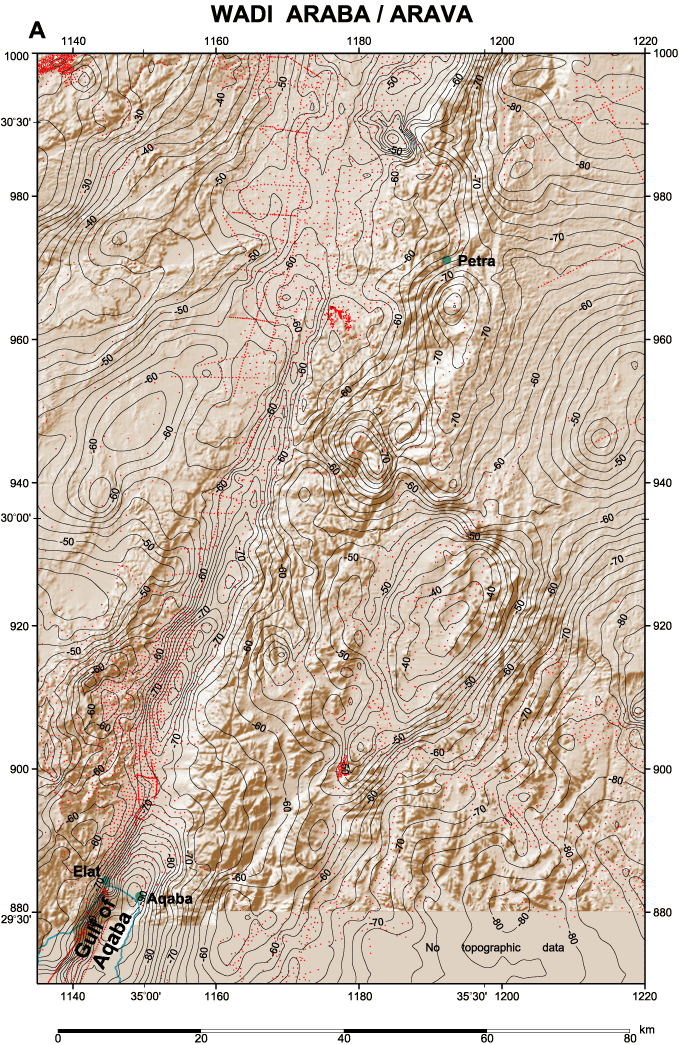
Map A: Wadi Araba/Arava
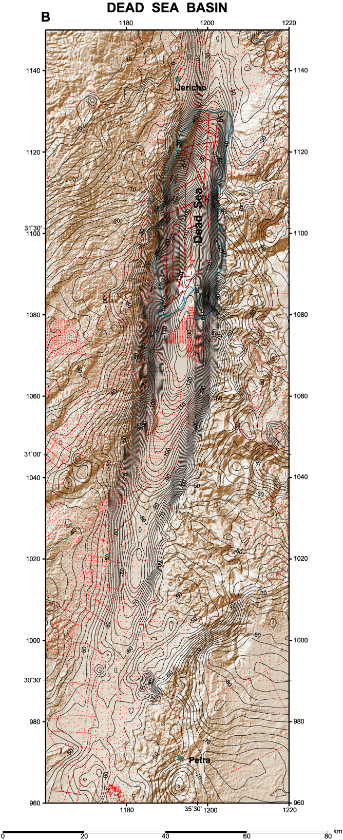
Map B: Dead Sea Basin
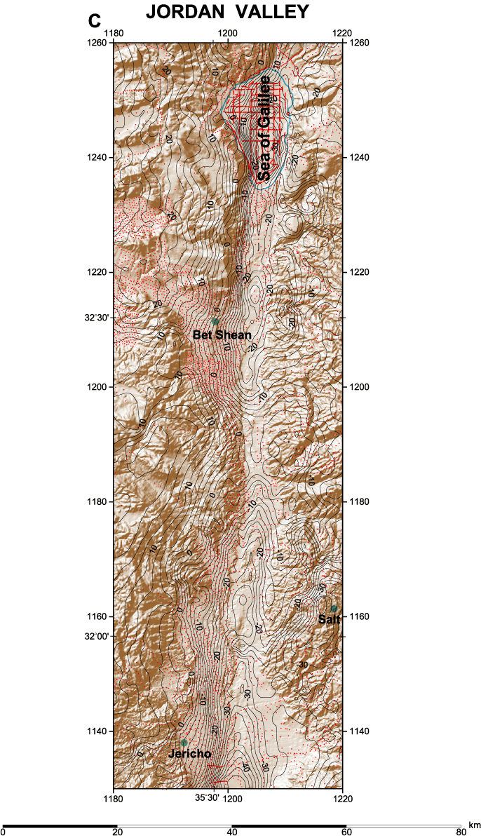
Map C: Jordan Valley

Location Map and Legend

This report is also available in paper form from:
      USGS Information Services
      Box 25286
      Denver Federal Center
      Denver, CO 80225-0046
      Tel: 888-ASK-USGS
      Fax: 303-202-4693
      Email: infoservices@usgs.gov
Click on a section of the map for a larger view.

The text portions of the report are reproduced at the top of this page.
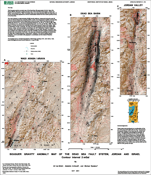

Bouguer Gravity Anomaly Map Image of the Dead Sea Fault System, Jordan and Israel, Wadi Araba, Arava Bouguer Gravity Anomaly Map Image of the Dead Sea Fault System, Jordan and Israel, Dead Sea Basin Bouguer Gravity Anomaly Map Image of the Dead Sea Fault System, Jordan and Israel, Jordan Valley Image of Legend: showing Gravity Station, Shore Line, Gravity Contour mGal, and Town Image of Location map and simplified plate geometry Image of the Bouguer Gravity Anomaly Map of the Dead Sea Fault System, Jordan and Israel
skip footer [an error occurred while processing this directive]