University of Kansas
Dept. of Geology
120 Lindley Hall
Lawrence, KS 66044
Telephone: (785) 864-4974
Fax: (785) 864-5276
e-mail: black@ku.edu, jdwalker@ku.edu
The computers are used in conjunction with undergraduate Field Camp, advanced graduate mapping courses, thesis and dissertation mapping, and geophysical and hydrological data acquisition. This paper describes the use of field computers by undergraduate and graduate students in general field mapping projects in courses, Field Camp, and thesis work.
The systems also allow other technologies to be easily integrated into the mapping process. While it is still imperative to teach students how to locate themselves on the topographic map by traditional methods, such as triangulation, it is now very easy to integrate GPS technology into the mapping process. The GPS units can be hooked directly to the computer via a cable. However, our students have found the cable to be inconvenient and really unnecessary because the software tracks the cursor location. The student just reads the map coordinate off of the GPS screen and moves the cursor to that point on the screen before drawing the geological feature on the map.
The major step forward for the students, however, is that the entire mapping process is streamlined. Data acquisition, database development, and map production are now all one seamless process. In the past, these were separate processes requiring transferring the map information manually onto multiple media or typing and digitizing the field information manually if a computer was used for map compilation back at base camp. This tedious, time consuming work is now unnecessary, since the database is built on the fly and the map can simply be printed out every evening. It is also much more convenient for the students to back up the files to tape each night and not have to worry about the map being destroyed by accident.
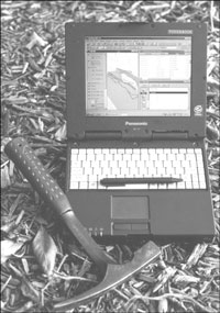
In 2000 we purchased five new, smaller units. These were Panasonic Toughbooks (http://www.panasonic.com/), which only weigh about four pounds (Figure 1). They have a smaller screen, about eight inches across, and a smaller keyboard, which bothered some of the larger students. However, these units were so light and rugged that they were vastly more popular that the original Rocky units. More importantly, these units had sunlight-readable touch screens. Our software extension to the commercial GIS software is essentially a point and touch interface for the field geologist, such that no typing is necessary on the outcrop, unless the student chose to also use the computer as a digital field notebook. Most students found this to be most convenient, in spite of the small keyboard.
|
Figure 1. Panasonic Toughbook ruggedized laptop computer with rock hammer for scale. A field map and editable data tables are shown on the screen. |
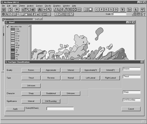
Figure 2. The GeoEditor software features drop-down windows for classifying contacts, rock units, and other geological features on the fly. |
|
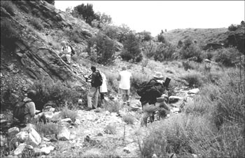
Figure 3. Undergraduate students using field-hardened laptop computers on the outcrop. The systems have been used as part of the field camp curriculum for the past three summers. |
We give each group a similar introduction to using ArcView and GeoEditor. This consists of a ~three hour course on basic GIS functions and digitizing. Such tasks as attribute identification, spatial query, and snapping of one line to another are done during this introduction. Previously, this tutorial was done at field camp; presently we are doing this as a standard laboratory exercise in the undergraduate structural geology course (required of all students taking field camp).
The results of our teaching experience have been mostly positive. The only group that did not adapt immediately and well to using field computers was the graduate students. They had some difficulties adjusting to mapping on computers in the field and it took several days for them to become proficient and comfortable. One student in particular thought that the use of computers in the field was distracting and unnecessary (see further comments below). The undergraduates, on the other hand, wholly embraced the use of GIS and field computers for mapping. Most students were mapping well by the end of the first day, and all by the middle morning of the second. Most students also integrated their note taking into the computer.
Moreover, the undergraduate mapping experience seems to have been enhanced by the use of the field computers and GIS software. There are many reasons for this. First, field camp is the first experience that most students have with drafting illustrations using pencil/pen and paper/mylar. Most of the graduate students and current geologic professional have taken at least some technical illustration courses (the junior author of this paper, for example, had two and a half years of drafting courses in junior high and high school). For this reason, drawing and coloring maps neatly and proficiently is a much greater challenge than is realized (or admitted) by most field instructors. Several students have commented on how much easier it is to draft on a computer than keep track of colored pencils or try to keep rapidograph pens operating.
The second and possibly most important reason is that undergraduate students (and in a year or two, graduate students) have had computers incorporated into almost every aspect of their education. For this reason, using computers is not a new skill, but one that is well tested for them. In fact, one of the main reasons we have found for students having battery life problems in the field is that they spend their lunch time modifying the screen displays or playing games. Third, the field computer and database structure make many non-mapping tasks easier for the students. Because structural data (e.g., strikes and dips) are stored in a database, they can be imported directly or with slight modification into stereonet programs. Stereograms and their interpretations can then be easily generated, skipping several non-geologic steps for the student. In addition, topographic profiles generated from digital elevation models (DEMs) can be extracted by the software and plotted directly on the geologic map. This allows for more accurate and much faster generation of geologic cross sections for the students. The cross sections can then be compared to the map viewed on topography using 3-D visualization packages. All this means that the students can spend more time on the geology and interpretation, and less on mundane and tedious tasks.
A major factor in the choice of any computer to be used in a field environment is the readability of the screen in direct sunlight. Some older, inexpensive LCD technologies were not sunlight-readable. The newer active matrix screens are usually at least adequate for the job. Touch screens are a major advantage when performing mapping, as drawing directly on the basemap with a pencil-like stylus is much more natural than drawing with a cursor and touchpad or trackball. In addition, if the software is properly designed, much of the data entry can be reduced to tapping buttons on the screen for the most common rock types, structures and other features.
Without modification, off-the-shelf GIS programs are adequate for geological field mapping, but are rather hard to use. ArcView is no exception. However, the program can be customized through the writing of "extensions". In early versions of the program these extensions had to be written in a proprietary language, Avenues. (GeoEditor is an example of such an extension.) The recently released version can apparently be customized using Visual Basic.
There are also several pedagogical advantages. First, students can map on multiple basemaps using standard topographic maps, DEMs, satellite images, or aerial photographs. In this way the students gain experience and insight into remote sensing and other data. Second, it is easy to overlay maps from different students. This can lead to discussion and insights into why contacts may be placed in different locations from map to map. Lastly, the computer allows for easy map compilation and presentation.
One of the biggest advantages for using GIS software and a database approach to geologic maps is that it forces students to classify features as they enter data in the field. Because of this, students cannot return at the end of the day with maps where they do not understand the nature of some of the geologic contacts. This makes the students much more aware of how they map and that they must examine features in the field.
Perhaps the most telling episode to us about the value of the field-based computer approach is an experience we had with the teaching assistant (TA) for the 2001 undergraduate field camp. This TA was the same graduate student who took the graduate course three years earlier and disliked the system (see above). After being a TA and working with the field computers for three weeks, he declared that he wished he had the opportunity to use the system in his field mapping.
Walker, J.D., and Black, R.A., 2000, Mapping the Outcrop: Geotimes, v. 45, no. 11, pp. 28-31.