USGS, Mid-Continent Mapping Center
1400 Independence Road
Rolla, MO 65401
Telephone: (573) 308-3765
Fax: (573) 308-3652
e-mail: rbradford@usgs.gov
The concept to develop a prototype central United States atlas for electronic presentation of geospatial data initiated from the need to increase public knowledge of USGS products, data, and services including NMD Geospatial Data and Science Programs and GD National Cooperative Geologic Mapping Program and National Earthquake Hazards Reduction Program, and to increase public awareness of earthquake risks in the central United States. With the availability of internet access, GIS technologies and geospatial data, users will have the capability to evaluate options and make informed management decisions that effectively reduce economic risks and improve public safety.
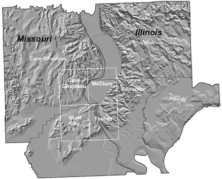
The prototype atlas will be comprised of multi-scale products ranging from 1:24,000 to 1:2,000,000 including existing and new map data. For the larger-scale prototype, a 15-minute area was selected for the 1:24,000 quadrangles including the Cape Girardeau, Thebes, Scott City and McClure quads (figure 1). The geographic and cartographic data sets include Digital Raster Graphics (DRG), Digital Orthophoto Quads (DOQ), Digital Elevation Models (DEM), Digital Line Graphs (DLG), Geographic Names (GNIS), Environmental Protection Agency (EPA) chemical sites and Corps of Engineers (COE) data. The geologic data sets include four main layers: bedrock, surficial, fault and point. These layers have attributed and symbolized using ArcInfo and ArcView. Other historical geologic maps will be included as well as new data from the Missouri Geological Survey and Central United States Earthquake Consortium (CUSEC)- State Geologists. A limited number of geospatial data layers have been merged only for product prototypes at this time. In addition, these layers have been merged and edge aligned for the 7.5-minute data sets listed above to produce a 15-minute prototype product.
|
Figure 1. Map showing area of the prototype, within the four named 7.5' (1:24,000-scale) quadrangles. |
For the medium-scale prototype at 1:100,000, the new 1:24,000 data will be incorporated with the existing 30 x 60-minute Cape Girardeau quadrangle data. For the smaller-scale prototype at 1:250,000, the CUSEC Paducah quadrangle and other existing data will be used for products. All prototypes will require peer technical reviews and geologic evaluations before providing access to these data. For internal review purposes only, a limited number of 7.5-minute data sets have been demonstrated using ArcIMS.
These digital geospatial data will provide users with information that can be easily integrated into other Web applications and promote the value of regional geologic data integrated with other geographic and cartographic data.