
Digital Mapping Techniques '01 -- Workshop Proceedings
U.S. Geological Survey Open-File Report 01-223
A Case Study in Database Design: The Alaska Geologic Database
By Lawrence K. Freeman
Alaska Division of Geological and Geophysical Surveys
794 University Ave, Suite 200
Fairbanks, AK 99709-3645
Telephone: (907) 451-5027
Fax: (907) 451-5050
e-mail: Larry_Freeman@dnr.state.ak.us
THE CHALLENGE
In designing a spatially referenced geologic database for Alaska, the Division of Geological and Geophysical Surveys (DGGS) encountered several unique problems not experienced by geological surveys in the rest of the United States:
- Alaska's size and its northern latitude combine to complicate unified digital mapping.
- Alaska has more surface area than the next three largest states combined
(see http://www.dced.state.ak.us/tourism/student/
student7.htm).
- Alaska comprises one hundred fifty-three 1:250,000-scale quadrangle maps, 11 UTM grid zones, five principal meridians, and GIS data in multiple projections.
The complex and sometimes active Alaskan geologic environment supports numerous agencies that collect, store, and distribute geologic data. The database under construction must coordinate with data stored by at least 11 other agencies and institutions. During 2000, these agencies tracked, among other things, 154 earthquakes over magnitude 4.0 http://giseis.alaska.edu/Seis/
html_docs/db2catalog.html, 21 potentially active volcanoes http://www.avo.alaska.edu/avo4/atlas/intro.htm, $1 billion worth of minerals extraction (Szumigala and Swainbank, 2001), and nearly 400 million barrels of oil production http://www.dog.dnr.state.ak.us/oil/programs/
royalty/production.htm. Geologic resources information in Alaska changes daily, and is in high demand from the public.
Among other tasks, DGGS is charged with producing 1:63,360-scale geologic maps. To date, only 15 percent of the state has been mapped at that scale. Even with the small percentage of mapping completed, Alaska accounts for 4 percent of the entries in the National Geologic Names Database (GEOLEX) . Each geologic map produced by DGGS defines or redefines many map units. All of DGGS's new geologic maps are produced using ArcInfo, a geographic information system (GIS).
The most critical factor in preparing the database design now is personnel turnover in DGGS. Since 1990, the survey has changed dramatically. Certain tasks such as hydrology have been moved to other agencies. In 1990 DGGS had a staff of 36 (not including the Hydrology Section); at present there are 27 on staff, but only 12 of the staff members from 1990 remain. Digital data files stored on individual hard drives, CD-ROMS, Zip disks, and outdated media is at risk for corruption, loss, and obsolescence due to DGGS staff turnover. A unified, centralized data storage, entry, and retrieval system will plug this data drain.
ACKNOWLEDGMENT
This project encompasses the data and database configuration work required of the Alaska Division of Geological & Geophysical Surveys (DGGS) as part of the interagency Minerals Data and Information Rescue in Alaska (MDIRA) project. Funding for the DGGS database creation is through a contract from the U.S. Geological Survey (USGS), as part of the MDIRA.
MEETING THE CHALLENGE
"The DGGS geologic database system will maintain a consistent data and information archival input, organization, and storage architecture and will provide data identification and retrieval functions that guide and encourage users to access appropriate data on-line." Milt Wiltse, Alaska State Geologist (written communication, 2000).
Methods
The initial step in DGGS's database design process was an internal needs assessment. This consisted of interviews with individuals and working groups mostly within the survey. Everyone in DGGS, and some key players outside of DGGS such as in the USGS in Alaska, University of Alaska, and the Alaska Department of Natural Resources (DNR), were interviewed. These interviews resulted in a long list of function statements such as "DGGS geologists record coordinates, an accuracy estimate, date, place name, project, and comments for each field station." Part of this process included gathering samples of forms, reports, tables, maps, and legacy databases. Lists of data processes, entities and attributes, relationships, and rules were distilled out of this process; this was the initial data model.
The second step of this process was verification of the initial model. The entire DGGS staff participated in multiple focus group discussions, multi-part surveys, and a request for geologic questions. The group discussions were used to rewrite the original model, the surveys were used to prioritize the model, and the questions will be used to check that all the entities, attributes, and relationships are present. The data model (fig. 1), a robust, entity-relationship diagram, was constructed in Microsoft Visio.
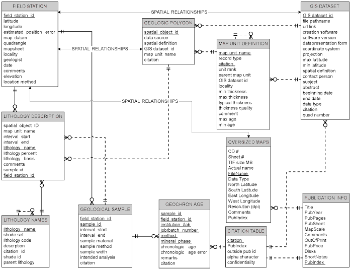
Figure 1. Entity-relationship diagram with selected entities from each of the seven functional groups of the DGGS Alaskan geologic database.
|
Conceptual Data Model
The data model resulting from this process is subdivided into seven major data groups subdivided by function and type. The groups are field data, sample data, geologic map objects, spatial dataset inventory, reference/legend information, publications database, and thematic databases. A diagram showing the data model is available in PDF format, at http://wwwdggs.dnr.state.ak.us/download/
rfp_2002_1000_2669_app7.pdf.
Field data includes location, descriptive, and instrumental data recorded in the field. Data recording is largely manual, using state-of-the-art, analog methods�field note books, in plain English. Field locations include three types: outcrop observations, measured sections, and well logs. Entities include location information, lithology description, map unit, structural measurement, sample description, photograph information, magnetic susceptibility measurements, water level, permafrost level, penetration test, seismic velocity, alteration description, mineralization description, morphology description, and paleoenvironment description. If the database system is capable and robust, field sketches and detail maps could be included as graphic files.
Sample data comprises descriptive, instrumental, and chemical analyses that are completed after the end of the field season. Samples are identified by a sample number and are always associated with a field station. These data include whole-rock major and minor element analyses, trace-metal analyses, isotope geochemistry, organic geochemistry, coal analyses, petrography, paleontology reports, geochronology, and materials engineering tests. Laboratory information and cited references are related to each sample analysis. Each analysis is related through the sample description and sample number to a field location in the field database.
Geologic map objects include polygons and lines. They are generally located through analog means on hard-copy maps and then digitized in ArcInfo or MapInfo. Attributes of map objects in the DGGS system are similar to those of the North American Geologic Map Data Model (Johnson and others, 1999). The goal is to be compatible with both the Geologic Map Data Model and with the data model being used to digitize 1:250,000-scale maps in Alaska (for example see Wilson and others, 1998) as well as to serve DGGS needs. In the DGGS data model, geologic polygons have attributes including spatial definition, lithology, maximum and minimum geologic age, characteristic fossils, thickness, spatial object and dataset identification, and map unit name. Geologic line objects tracked in the database will only consist of significant features including faults and unconformities. Line attributes include spatial definition, spatial object and dataset identification, type of feature, minimum and maximum age of feature, location accuracy estimate, orientation, and feature name. Storing a spatial definition of geologic map objects in a relational database system will allow statewide queries based on geologic mapping.
The spatial dataset inventory will hold or link to metadata elements for GIS datasets created or housed in the DGGS system. The attributes of the inventory will be compatible with the Federal Geographic Data Committee (FGDC) metadata standard http://www.fgdc.gov/
standards/documents/standards/metadata/v2_0698.pdf and the National Geologic Map Database (NGMDB) http://ncgmp.usgs.gov/ngmdbproject/cathelp/manual.html. Each record will include a file path name so that a user on the DGGS system can open a selected dataset. Having this inventory will help DGGS geologists to eliminate duplication and to share work more readily. It will also help keep track of all the projections and grid systems so DGGS can ensure that projections and grid systems are used consistently.
Reference/legend information includes all the nomenclature, terminology, bibliographic information, and spatial definitions of attributes and objects used throughout the database. Entities include lithology, map units, named structures, and cited references. Each entity will be defined and many will have internal hierarchical relationships. These tables will be used to validate data entry elsewhere in the database. This information can also be used in making map legends, compiling metadata, and assisting with data searches. In essence, this will be our digital reference library and the foundation of a functional database.
The Publications Database is, in part, a subset of the cited reference information but contains more information specific to DGGS publications. The publications database will help manage data access, sales, distribution, and production of our publications.
Thematic databases include information specific to minerals resources and geologic hazards. Most of the databases refer to point-type spatial objects, but some will be line- and polygon-type objects as well. Some databases will only contain minimal information, but will contain links to databases held by other agencies. Database entities will include mines and prospects, coal resources, minerals industry activity, Holocene faults, seismic events, active volcanoes, and geotechnical boreholes. Some of these databases are legacy databases that will be resurrected, others are under construction now, and still others are awaiting development of the DGGS database system. Specific links for minerals resources will include the Alaska Resource Data Files (ARDF) http://ardf.wr.usgs.gov/ and the Minerals Availability System/Minerals Industry Location System (MAS/MILS) http://imcg.wr.usgs.gov/dem.html, http://imcg.wr.usgs.gov/cgi-bin//qalaska3.cgi. The database will link to an earthquake database, Alaska Earthquake Information Center (AEIS)
http://giseis.alaska.edu/Seis/html_docs/db2catalog.html, for seismic events and the Alaska Volcano Observatory volcano atlas http://www.avo.alaska.edu/avo4/atlas/atlas.htm. The thematic databases will be related to the geologic sample, cited reference, and field data databases; they will be related to geologic objects through the spatial definitions.
Data System
DGGS already has significant computer resources including at least 45 desktop computers (running Windows NT and Windows 2000), 12 portable computers (running Windows 98 and 2000), six Sun workstations served by a Sun Ultrasparc Enterprise 450, and the numerous switches, printers, plotters, and scanners that make up our local area network (LAN). Our GIS consists of ArcInfo8, operating on the Sun system, and served to the Windows machines over the LAN. It is essential that the database system operate within these physical constraints.
Point data such as field stations and sample sites may be located by GPS or by digitizing from maps. We will continue to create maps and the geologic objects on them by working on hard-copy maps in the field, then digitizing semi-final maps into our GIS system. Interpretation will be facilitated by having field, sample, and imagery available in the GIS. When the maps have reached the final technical review then geologic objects will be transferred into the database and will have attributes assigned. Other entities with spatial attributes will be treated like geologic map objects, digitized and checked in the GIS, then attributed in the database. Data will be queried in the database and then viewed in the GIS or output as tables, in custom forms, or for use with other software.
The database system will consist of a data server, a relational database management software package, and connections and utilities to interface with the DGGS LAN and GIS. It is essential that the database system be capable of holding spatial data and able to complete spatial searches, as almost all of DGGS data has spatial attributes. The storage capacity of the system needs to be large; our geologic, geochemical, and geophysical map inventory contains over 4,000 maps. The database system must also function with DGGS's GIS system. The database must also be available to multiple users on SUN workstations and on Windows machines via our LAN. DGGS geologists also need to be able to replicate spatially constrained sets of the data for seasonal fieldwork on portable computers. At this point, we envision using Oracle 8i with Oracle Spatial served on a Sun or Windows NT data server. We would need to add ArcSDE to the GIS to facilitate transfer of spatial data from project files to the database. DGGS intends to continue to use ArcInfo GIS as its main geologic mapping, analysis, and cartographic tool and to supplement it with a centralized relational database to manage all the data.
Implementation Schedule
DGGS has issued a Request For Proposal for a contract to install the database system hardware and software, to design and program the database and supporting functions, and to train staff and support the system for the first two years. We expect to have the system installed and operational by the end of 2001. By April 2002, we will have digital data loaded, and will start digitizing and loading our prioritized legacy hard-copy data.
During the next six months, we will be working with other agencies in the Interagency Minerals Coordinating Group, Alaska Department of Natural Resources, and the NGMDB to coordinate data transfer, and determine Internet data needs; we will also look to the Alaska public to determine the scope and style of Internet access to the data. By the end of 2002, we intend to have the database accessible to the public.
OUTCOME
The digital geologic database of Alaska will assist with the preservation and distribution of Alaska's mineral and geologic data. DGGS has already made all our publications available on the Internet http://wwwdggs.dnr.state.ak.us/
pubs.html and published a guide to Alaska minerals and geologic information (Daley, 1998) http://wwwdggs.dnr.
state.ak.us/Libguide/intropage.htm). The database will help us keep these publications and information current and will facilitate access by providing search tools. It will also broaden the scope of the information by showing where and what data is available, and how it can be accessed. The amount of information will grow by the addition in the database of appropriate links to other agencies and institutions.
With this database, a casual user will be able to conduct searches of information and data, view the data, and download publications and datasets, all from an office or home. In a state like Alaska, with vast distances and travel limitations, this kind of access is vital.
REFERENCES
Daley, E.E., 1998, Guide to Alaska Geologic and Mineral Information: Alaska Division of Geological and Geophysical Surveys Information Circular 44, 90 p.
Johnson, B.R., Brodaric, B., Gary L. Raines, Hastings, J.T., and Wahl, R., 1999, Digital geologic map model; Version 4.3: Unpublished Association of American State Geologists/U.S. Geological Survey draft document, 69 p., http://geology.usgs.gov/dm/model/Model43a.pdf
Szumigala, D.J., and Swainbank, R.C., 2001, Alaska's mineral industry 2000: A summary: Alaska Division of Geological & Geophysical Surveys Information Circular 47, 14 p., http://wwwdggs.dnr.state.ak.us/download/ic47.pdf
Wilson, F.H., Dover, J.H., Bradley, D.C., Weber, F.R., Bundtzen, T.K., and Haeussler, P.J., 1998, Geologic map of central (interior) Alaska: U.S. Geological Survey Open-File Report OF 98-133, 1:250,000 scale, http://wrgis.wr.usgs.gov/open-file/of98-133-a/
RETURN TO Contents
National Cooperative Geologic
Mapping Program | Geologic Division |
Open-File Reports
U.S. Department of the Interior, U.S. Geological Survey
URL: https://pubsdata.usgs.gov/pubs/of/2001/of01-223/freeman.html
Maintained by David R. Soller
Last modified: 18:24:38 Wed 07 Dec 2016
Privacy statement | General disclaimer | Accessibility