|
1National Park Service Intermountain GIS Center University of New Mexico Bandelier Hall West Albuquerque, NM Telephone: (505) 346-2885 x260 Fax: (505) 346-2889 e-mail: Anne_Poole@nps.gov
2National Park Service |
3National Park Service Geologic Resources Division 12795 West Alameda Parkway P.O. Box 25287 Denver, CO 80225 Telephone: (303) 969-2093 Fax: (303) 987-6792 e-mail: Tim_Connors@nps.gov
4National Park Service |
5GIS Operations Mesa Verde National Park P.O. Box 8 Mesa Verde, CO 81330 Telephone: (970) 529-4614 Fax: (970) 529-5028 e-mail: Allan_Loy@nps.gov |
The current version of the digital map model (Fryer et al., 2000) outlines a series of ArcInfo coverages. Each GIS layer represents a different type of geologic information digitized from the source map. While most of these layers consist of only one type of feature (point, line, or polygon), some, such as CODEGLG, include both line and polygon data. Accessory INFO tables hold additional data on rock unit type and age, and reference information on the source maps used to create the coverages. This model was originally developed from the Washington State ArcInfo GIS data model (Harris 1998) and has been extended to include components of the North American Geologic Map Data Model (Johnson et al., 1998).
It is the goal of the NPS Inventory and Monitoring Program to produce digital products that are immediately useful to anyone familiar with their analog counterparts - in this case, a paper geologic map. Therefore, each digital geologic map product will come with ArcView legend files that automatically display the proper shades and symbols for each data type. Map unit descriptions will also be automated by including them in a Windows Help File that can be linked with CODEGLG and other coverages in a customized ArcView project.
Some examples of geologic themes in the data model and the accessory data files to which they are linked are listed in Figure 1. In an actual geologic map for a park, the "CODE" portion of the coverage name is replaced by an official four-letter code used to identify each NPS unit (i.e. "MEVE" for Mesa Verde National Park). Figure 2 illustrates how certain coverages may contain both area (i.e. rock type) and line (contact type) features.
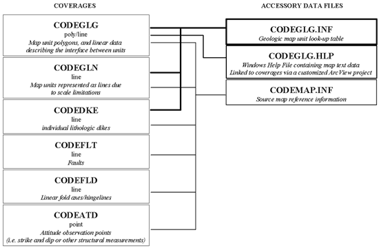
Figure 1. Some examples of geologic themes in the data model and the accessory data files to which they are linked. |
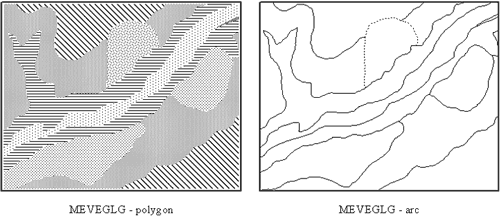
Figure 2. Some coverages contain both polygon and arc features. For example, MEVEGLG stores information on both rock type and contact line type. |
Customized ArcView legend files (showing standardized symbology and/or colors pertaining to the age of the rock unit) were created and distributed along with the digital data to the park's GIS staff. When possible, these legends were given the same name as their associated coverage, so that they will load automatically when placed in the same directory as that coverage. These files are not only great timesavers but are also aids to anyone unfamiliar with either geologic data representation or the manipulation of the appearance of data in a GIS.
Rock type descriptions provided by Dr. Griffitts, as well as legend text from older maps of the area, were included in an accompanying Windows Help File, MEVEUNIT.HLP. In this file each map unit is listed on its own topic page, which is given an ID code identical to the unit's geologic symbol (which is also listed in the GLG_SYM field in certain coverages and hence serves as the link between coverage and help file). A contents page shows the names of all units in their proper stratigraphic order, and a references page lists sources from which the descriptions were derived. Keyword searches can be performed on this file using terms pertaining to lithology, formal unit names, time period, and other aspects. This help file, in addition to being useful on its own, is designed to be incorporated into the NPS Theme Manager, an ArcView extension developed to allow park staff with little GIS knowledge to access geographic data.
The new geologic resources inventory has been incorporated into Mesa Verde's GIS and has already been employed for post-wildfire geologic hazards studies. We anticipate that it will continue to prove its usefulness as new resource management issues arise.
Harris, C.F.T., 1998, Washington State's 1:100,000-Scale Geologic Map Database: An ArcInfo Data Model Example, in D.R. Soller, ed., Digital Mapping Techniques '98 -- Workshop Proceedings: U.S. Geological Survey Open-File Report 98-487, p. 27-35, https://pubs.usgs.gov/openfile/of98-487/harris.html.
Johnson, B.R., Brodaric, Boyan and Raines, G.L., 1998, Draft Digital Geologic Map Data Model, Version 4.2: American Assoc. of State Geologists/U.S. Geological Survey Geologic Map Data Model Working Group, May 19, 1998, http://geology.usgs.gov/dm/model/Model42.pdf.