Arizona Geological Survey
416 W. Congress, #100
Tucson, AZ 85701
Telephone: (520) 770-3500
Fax: (520) 770-3505
e-mail: srichard@iname.com or Richard_Steve@pop.state.az.us
The definition of mappable units is the fundamental problem that must be solved by a geologist in the field. The process is complicated for many reasons. The Earth is heterogeneous. There are continuous variations in many rock properties at many scales. Not much of the Earth is directly observable. The definition of mappable units will reflect the interests that motivate a geologist to study the geology of an area, as well as the experience and education of the geologist (Brodaric and Gahegan, 2000).
The Earth is typically subdivided into bodies of material that can be recognized based on some observable features. Two common approaches to defining rock bodies are 1) to define bodies bounded by surfaces that can be identified (e.g. a stratigraphic unit bounded by marker beds); and 2) to define bodies based on identifying characteristics of the material itself (e.g. a particular kind of granite). In the first case, the lithology of the rock body itself may be relatively consistent, but does not provide sufficient conditions to identify the unit; the boundary surface must be identified to determine if a particular segment of the Earth is within or outside the unit. In the second case, the properties of the rock body itself define sufficient conditions to identify the unit. Rock units of this second type are the focus of the following discussion and will be referred to in this paper without further elaboration as "rock volume units". Although any observable feature may be used to define a rock volume unit; this paper is concerned with rock volume units whose definition is based on lithology (physical characteristics of a rock).
Rock volume units are rock bodies that are identified by a set of defining lithologic characteristics. The definition of a rock volume unit has an implicit dimension over which the defining characteristics may be considered homogeneous (Table 1). This dimension defines the smallest volume of rock that is representative of the entire unit. This representative volume is analogous to a unit cell in crystallography. Many rock volume units are heterogeneous at several scales. This heterogeneity is accommodated by either expanding the representative volume of rock in the definition, or by defining the unit as composite, with more than one lithologic component, each with its own "defining representative volume". A composite unit definition must also include a description of the characteristic relationships between the lithologic components. This paper is a discussion of some of the rules and assumptions underlying the definition of rock volume units necessary to form a classification system.
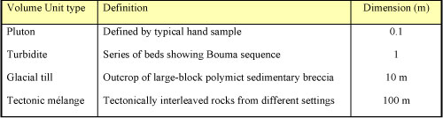
[Click here for a Word version of this table.] |
Different kinds of classification systems are defined based on the multiplicity of the mapping between objects in the classification domain and the classes in the system (Hainaut et al., 1996):
This varying degree of specificity leads to a hierarchy of classification that is an inherent part of the classification system. At the top of the hierarchy are classes with non-restrictive definitions, and relatively large membership. Each level of the hierarchy narrows the definition for class membership, grouping classified objects into smaller and smaller subsets. Classification of rocks thus varies along two major axes-the degree of classification specificity and the dimension of the representative volume classified. Hand-sample-dimension lithologic classification systems are designed to group kinds of rocks based on a 1-30 cm diameter representative volume. A particular hand-sample rock name, based on a naming scheme like that proposed by the British Geological Survey (e.g. Robertson,1999), is a very specific kind of rock volume classification meant to identify a particular rock body characterized at the dimension of a hand-sample. A geologic rock-volume map unit is a relatively specific classification meant to identify a particular rock body, but the dimension of the representative volume may vary from hand-sample size to km-scale. A lithologic map unit is a less specific rock-volume classification meant to group similar kinds of geologic rock-volume units.
Because what we observe is determined by our biology, there is a level of rock classification that is "natural" to most people. At this basic level, chunks of sensory input are processed as a whole, not an aggregation of parts, much in the manner that we recognize a face (Lakoff, 1987). Everyday rock names recognized by non-geologists represent this basic level of rock classification. Such terms include granite, schist, gneiss, sandstone, slate and marble. A basic-level classification system for a trained geologist would include a wider variety of classifications, but the exact list would depend on the experience and the interests of the geologist. Basic-level rock classes are identifiable without close inspection, limiting the classification criteria to features observable with the unaided human eye. This places an effective minimum dimension limit on the order of 1 cm, and a maximum dimension limit on the order of 300 m-about the largest mountain-scale outcrop that can be taken in at one look.
This basic level rock classification should form the core (most commonly used part) of a rock-classification hierarchy in a geologic data system. Only simple fabric and mineralogical criteria are applicable to this sort of classification. More specific rock classes, which sub-divide the "basic level classes", are defined using more subtle criteria, e.g. detailed modal mineralogy, grain-size distribution, or fabric criteria. More general super-classes group basic-level classes, typically based on more theoretical, genetic criteria, e.g. igneous, sedimentary, metamorphic, intrusive, extrusive, or based on compositional grouping, e.g. terrigineous, carbonate, pelitic.
Because the basic-level rock classification used by geologists is based only on simple fabric and mineralogical criteria, it is insufficient for a classification system that unambiguously defines class membership. The system works well for common rocks that are similar for the prototypes for each class, but classification becomes ambiguous for rocks that do not clearly match a prototype. The boundaries between the classes are fuzzy, and lithology varies continuously over many descriptive variables. The basic level classification does not clearly define boundaries between many classes in the lithologic continuum, e.g. gneiss vs. schist, sandstone vs. mudstone, hornfels vs. slate, granite vs. diorite, cal-clastic sandstone vs. limestone. Consensus among geologists on the exact definitions of the boundaries can not be expected, and in many cases will seem arbitrary. Nevertheless, these boundaries must be unambiguously defined in a geologic information system useful to both geologists and non-geologists, such that the results of queries to the system are predictable, comprehensible, and reproducible.
The domain for a rock volume unit classification system is defined to be "any volume of the solid Earth that may be described for the identification of a particular material body in the Earth". The representative volume used to define a rock volume unit must be large enough to be characterized as an aggregate of constituent parts (Richard, 1999). In practical terms, this means the smallest representative volumes are on the order of 1-10 cubic centimeters.
A rock volume classification system for use in a geoscience information system must be total, so that any rock can be classified. However, there are many examples of rocks that can be recognized as belonging to more than one class, depending on the criteria used for classification. Examples include low-grade metasedimentary rocks that may be described as metamorphic rocks and as sedimentary rocks, saprolites that may be described as surficial geologic units and as their bedrock parent, and calc-lithic sandstone that may be classified as both a sandstone and a limestone. Any classification system that attempts to define disjoint classes over the entire domain of "rocks" must define ad hoc rules for classifying such rocks into unique classes, or add numerous new classes that include such composite kinds of rocks. A better solution is to allow separate classification schemes, based on different classification criteria, that are designed to classify rocks within some sub-domain of rocks. The domains of classification for these schemes may overlap, but classes in any particular scheme are disjoint. Rock volume classification over the whole domain of rocks is thus overlapping, or not disjoint.
In order to produce a classification system for rock volume units that allows different observers to classify rocks in the same way, the system must be based on physical properties of the rock recognizable by all observers. Strict adherence to this rule would not allow use of genetic interpretations in the classification of a rock volume unless they could be couched in purely descriptive terms. The properties used for field classification include modal mineralogy, grain size, grain shape, rock fabric (the arrangement of grains in an aggregate to form the rock), and structures in the rock (bedding, layering, etc.). Rock volume units may be defined based on other physical properties, such as magnetic susceptibility or density, but these are not generally used as field criteria.
In order to gain acceptance in the geoscience community, any rock classification system needs to be consistent with common usage. This may require some relaxation of the strict adherence to observable physical properties as criteria for classification, because traditional rock classification has always involved some genetic interpretation (igneous, sedimentary, metamorphic are fundamentally genetic). The operational rules for consistency are that existing terms may be redefined to narrow their meaning, but may not be redefined to include rocks that are not included as part of that class in common usage.
At the smallest scale of lithologic description, the parts of a rock volume are grains of individual mineral substances. This is the scale of standard "hand-sample" rock classification, e.g. a granite is a rock that consists of an aggregate of quartz, K-feldspar, and plagioclase in certain proportions with a certain fabric (relationship between grains). This description may serve to define a single lithologic component representative of a homogeneous granite rock body (a pluton). More complex rock bodies that are internally heterogeneous are built up of parts that are themselves rock volume units. For example a conglomerate consists of an aggregation of clasts, each of which may have its own rock description. A migmatite is a mixed rock with particular kinds of rock-volume component parts in a particular arrangement. Some kinds of rock volume units are defined without specifying the hand-sample-scale description, for example classes like till or breccia do not depend on the particular hand-sample scale kinds of rock in the rock body. By expanding the dimension and complexity of the parts used to define a representative volume for a rock volume unit, units of arbitrary complexity may be defined.
Figure 1. Simple schema for description of rock volume unit. Notation is based on UML. |
Clearly, some constraints are desirable to assure that the descriptions of rock units are not absurd. Formal statement of the constraints is difficult. Intuitive constraints include: 1) Constituents playing a particular role in an aggregation must be distinct from other constituents in the same role. For example, if there are two kinds of quartz included in a sandstone, both playing the role "cement", then there must be criteria to distinguish the two kinds of quartz (e.g. transparent quartz, and inclusion-rich quartz); 2) The representative dimension that defines a constituent should be equal to or smaller than the representative dimension for the unit as a whole. For example, a tillite (representative dimension-10"s of m) could not be a lithologic constituent playing the role "clast" (with dimension <1 m) in the description of a cobble conglomerate; 3) In most cases, a rock volume unit can not be a constituent of itself, but this rule has exceptions, for example in extrusive volcanic autobreccia units.
Different earth scientists with different geologic foci may use different basic-level classification schemes. Individual rocks may be classified differently using different schemes. Different rock classification schemes have different classification criteria, and may have different domains of classification. The domains of different schemes may overlap, but each scheme must be covering (total and disjoint) within its domain of classification.
The approach to a lithologic classification proposed here is fundamentally descriptive. Classification of a lithologic constituent is based on observable features of the material, and assignment of a material to a lithologic class implies that certain descriptive criteria are met. These criteria must be defined in the database in order to document the classification system. The descriptions that define the lithologic classes also serve to provide default values for rock properties that are assigned to a lithologic class, but not described in greater detail. The definition of a lithologic class must be associated with a classification scheme that defines the domain of classification and classification criteria. The definition must state the dimension of the representative volume for the class, the criteria that are sufficient to assign membership in the class, and to the extent possible, a default description of other aspects of rocks that are assigned to the class.
How many classification schemes for subdomains of the domain of earth materials are required? This question does not have a clear answer. Several different subdomains for classification of hand-sample-dimension lithology are commonly recognized by earth scientists. Surficial materials are classified according to properties related to the deposition of the material and weathering of the material at the rock-atmosphere (or hydrosphere) interface. Igneous rocks are classified according to properties related to the crystallization of the rock from a melt. Sedimentary rocks are classified according to properties related to the deposition of sediment and diagenesis of the sediment to form rock. Metamorphic rocks are classified according to properties related to the changes in the rock that make it a metamorphic rock. Other subdomains are identified based on more specific genetic origins. Volcanic rocks are classified according to composition and eruptive processes that affect lithology, and the domain of volcanic rocks overlaps with that of sedimentary and igneous rocks. The domain of biogenic sedimentary rocks overlaps with that of epiclastic sedimentary rocks. The Science Language Technical Team (http://geology.usgs.gov/dm/steering/ teams/language/charter.shtml) formed under the auspices of the North American Data Model Steering Committee (http://geology.usgs.gov/dm/steering/) is currently developing standardized language for a rock classification system for the basic lithologic constituents of rock volume units.
There is no standard method of classifying map-unit-scale rock bodies according to lithologic criteria and many approaches are possible. Various classification systems are possible, each with some spatial scope and geologic intent. Until systematic approaches to such classification can be formalized, the usefulness of map-unit scale classification systems outside of their original spatial and thematic domain will be a function of how clearly the classes and boundaries between the classes are described.
Brodaric, B., and Gahegan, M., 2000, Geoscience Map Data Models, Open Systems GIS and Semantics: Proceedings, GeoCanada2000-The Millenium Geoscience Summit, Calgary, Alberta, p. 7.
Hainaut, Jean-Luc, Hick J.M., Englebert V., Henrard J., and Roland D., 1996, Representation of IS-A Relations: Dept. of Computer Science, Univ. of Namur, Belgium, Technical Report RP-96-016, available at http://www.info.fundp.ac.be/cgi-bin/pub-spec-paper?RP-96-016/ .
Lakoff, George, 1987, Women, Fire, and Dangerous Things: Chicago, IL, The University of Chicago Press, 614 p.
Richard, S. M., 1999, Geologic concept modeling, with examples for lithology and some other basic geoscience features, in Soller, D. R., ed., Digital Mapping Techniques 1999, Workshop Proceedings: U.S. Geological Survey Open-File Report 99-386, p. 59-75,
Robertson, S., 1999, Volume 2, Rock Classification, Metamorphic Rocks, in BGS Rock Classification Scheme: Nottingham, UK, British Geological Survey Research Report RR 99-02, 26 p.