U.S. Geological Survey
National Center, MS 903
12201 Sunrise Valley Drive
Reston, VA 20192
Telephone: (703) 648-4343
Fax: (703) 648-6138
e-mail: ekoozmin@usgs.gov
After peer review, the editing and production of the maps began in 1996. A decision was made to forego digitizing the map in ArcInfo and bridge the traditional-to-digital cartography gap by employing digital graphic production methods (such as Adobe Illustrator). Much of that decision was due to the state of the base-map materials and the fact that current technology had far supplanted their usefulness. Map editing was done using the hand-colored paper copies. Corrections were then made to the greenlines.
There are 65 map units, two of which are shown only in the cross sections. Linework consists solely of contacts, scarps, and arrows showing sediment flow directions or channels. Compared with a bedrock geologic map (which may have contacts, folds, faults, structural data, and many other features), one might think that the surficial counterpart would be much simpler to produce. A closer look at the maps, and some details about its production, reveal a deeper complexity.
The southern sheet was digitized and the polygons were tagged with the geologic unit identifications by GDS using AutoCAD. The data were exported as DXF files. Using the MAPublisher filter, the files were opened in AI, whereby each unit was automatically placed in its own layer; however, the DXF format had a limit of the number of nodes that could be used to create a polygon, and exceeding that number prevented the AI file from opening. GDS modified the DXF files by decreasing the number of nodes, but this step took several iterations to complete.
The central sheet also was digitized using AutoCAD and tagged by GDS, but this time the data were exported as ArcInfo SHAPE files. Again, using MAPublisher, the files were opened in AI, this time more easily than the DXF files, but all the units were in one layer. The units then were manually separated into their own layers. The total number of polygons for both sheets is about 7,000.
Once production was underway, a separate mosaic of the map's drainage linework (from the eight quadrangles) was produced. This mosaic was then scanned and digitized by GDS using AutoCAD. This step was necessary in order to ensure an accurate match to the geologic contacts because, for many of the units, either open-water shorelines (rivers, ponds, oceans, and marshes) or single-line drainages (creeks, some rivers) also acted as unit boundaries. After the geologic units were imported as described above, black geologic contact lines had to be "hidden" by the blue drainage lines. This task was accomplished in AI. Separate mosaics of culture and topographic contours also were produced and scanned.
|
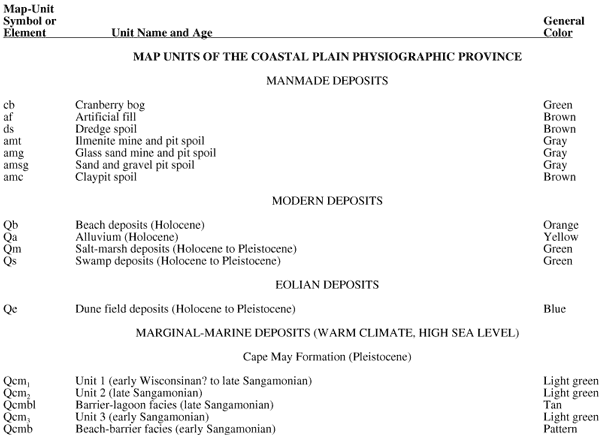
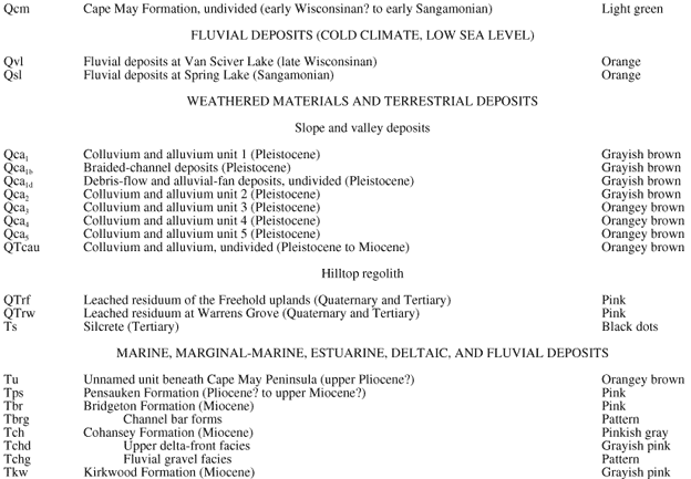
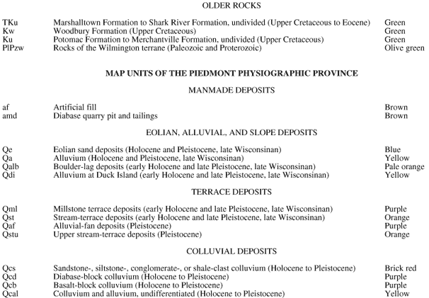
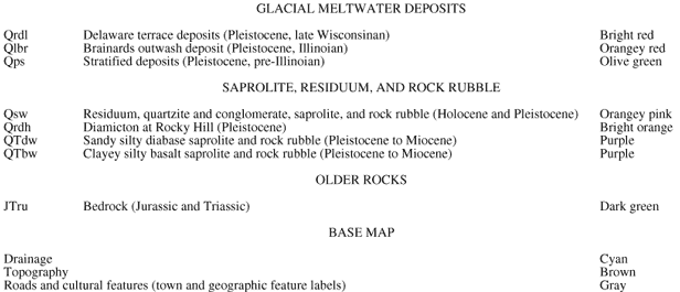
Table 1. Modified listing of geologic unit symbols, names and ages, and general colors used to depict the units (from youngest to oldest, as shown in the map's Description of Map Units). Colors for the base map also are listed.
[Click HERE for a Word version of this table.] |
The Quaternary sediments found throughout the map needed to contrast with the Tertiary and Cretaceous units, so they retained the traditional oranges and yellows. Dark browns, grays, and a dark green (for cranberry bogs) were used to show manmade units. The dune field deposits (unit Qe) needed to stand out on their own, so they are the only blue polygons on the map.
In the Piedmont, the authors wanted the very small colluvial, alluvial, and terrace deposits to be visible against the widespread residuum (unit Qsw). In addition, the diabase- and basalt-block colluvium, which were weathering products of the Triassic basin rocks, needed to be emphasized so that the underlying bedrock trend could be expressed. The entire Piedmont had to stand out clearly from the Coastal Plain, and it had to be matched to the unfinished northern sheet by Stone and others (in press); as it turned out, the color choices made on the central sheet eventually influenced many of the colors on the adjoining northern sheet.
In the Coastal Plain, there were several issues. The Pleistocene beach-barrier to lagoon units of the Cape May Formation needed to contrast with the modern beach deposits, so they were assigned a suite of bright green-yellow tones. A distinction needed to be made between freshwater-swamp and salt-marsh deposits, but both had to be green. The Pleistocene colluvial units needed to contrast well with the Tertiary and Cretaceous units from which they were derived. Lastly, the sinuous traces of ancient river-channel bar forms developed on the Bridgeton Formation needed a subtle representation; use of a pattern resolved that problem.
Because the digitizer at GDS was tagging polygons using the authors' hand-colored draft copy as a guide, some polygons were, in the end, unidentifiable and were tagged as such. Working with the authors, the cartographer was able to resolve these errors.
As mentioned above, joining the geologic contacts with the drainage required patient examination of many of the units for accurate placement. For instance, the alluvial units needed to be centered on the drainage. They also had to "V" upstream according to the topography.
In addition, when the senior author finally saw his map in a cleaner form, he observed that certain areas needed to be "fine tuned" for a variety of reasons. These types of adjustments were made in several areas on both sheets. In addition, the central sheet needed to join accurately with the northern sheet of Stone and others (in press).
However, the AI files were now far removed from the original DXF and SHAPE files. It is possible that, in the future, the AI files will be exported through MAPublisher to ArcInfo where they would become a useful part of a larger database (for instance, the National Geologic Map Database).
Stone, B.D., Stanford, S.D., and Witte, R.W., in press, Surficial geologic map of northern New Jersey: U.S. Geological Survey Miscellaneous Investigations Series Map I-2540-C, scale 1:100,000.