Coastal & Marine Geology Program
>
Subsidence and Fault Activation . . .
>
Open File Report 01-274
Return to:
Sediment-Surface Profiles
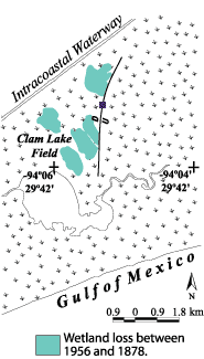
Fig. 3.
Location of sediment-surface profile (purple square) surveyed at the Clam Lake Field. Historical wetland loss generalized from White et al. (1987).
Click on a purple square to
view the profile
.
Return to:
Sediment-Surface Profiles
Coastal & Marine Geology Program
>
Subsidence and Fault Activation . . .
>
Open File Report 01-274
[an error occurred while processing this directive]