
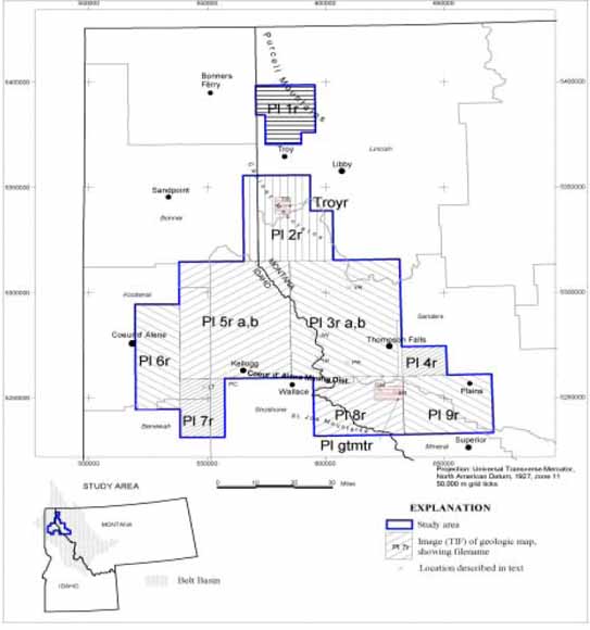
Geologic
maps of the western part of the Belt Basin of western Montana and northern
Idaho were converted into digital raster (TIFF image) format to facilitate
their manipulation in geographic information systems. The 85-mile x 100-mile
map area mostly contains rocks belonging to the lower and middle Belt
Supergroup. The area is of interest as these Middle Proterozoic strata
contain vein-type lead-zinc-silver deposits in the Coeur d’Alene
Mining District in the St. Regis and Revett formations and strata-bound
copper-silver deposits, such as the Troy mine, within the Revett Formation.
The Prichard Formation is also prospective for strata-bound lead-zinc
deposits because equivalent Belt strata in southern British Columbia,
Canada host the Sullivan lead-zinc deposit.
Map data converted to digital images include 13 geological maps at scales ranging from 1:48,000 to 1:12,000. Geologic map images produced from these maps by color scanning were registered to grid tick coverages in a Universal Transverse Mercator (North American Datum of 1927, zone 11) projection using ArcView Image Analysis. Geo-registering errors vary from 10 ft to 114 ft.
Download the 35-page report as a PDF document (of01-438.pdf; 29 MB)
Download the TIFF
images of these geologic maps (figures 2 –14)
this link leads to a directory containing the 13 images and
the 13 associated .TFW images that GIS users need; users are referred to table
1 in the report that links filenames with figure numbers]
Download PDF versions of these geologic maps (figures 2 –14) at the same scale as the TIFF images of these maps
Note about figures 2-14: Please note that the plate numbers in lower right corner of each figure are not sequential and do not correspond to the current numbering system of the figures.
Download PDF
versions of figures 1 and 15
[note: these two figures are also contained within the
report]
Download the Arc Export files
Download a separate
ASCII file of the FGDC-compliant metadata (24 KB)
[note: the metadata is also included in the PDF of the
report as Appendix II]
For questions about the content of this report, contact Dave Boleneus or Mike Zientek
Download a free copy of the latest version of Adobe Reader.
|
Help |
PDF help |
Publications main page |
| Western Open-File Reports for 2001 |
| Geology | Western Mineral Resources

![]() U.S. Department of the Interior | U.S. Geological Survey
U.S. Department of the Interior | U.S. Geological Survey
URL: https://pubs.usgs.gov/of/2001/of01-438//
Page Contact Information: Michael Diggles
Created June 16, 2008 (cad)
Page Last Modified: June 16, 2008 (mfd)