
Configuration of the Seattle Urban Seismic Array
for the February 28, 2001, M6.8, Nisqually Earthquake and its Aftershocks
by
David Carver1,
A. D. Frankel1,W. T. Bice1, B. Norris2, and
N. Dickman1
Open-File Report 01-344
1 Golden, Colorado
2 Seattle, Washington
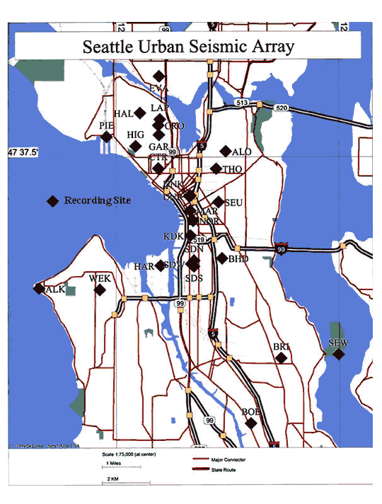
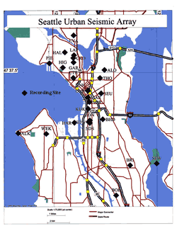 This is a description
of the configuration of the Seattle Urban Seismic Array (click on thumbnail
map to see full size map) at the time of the Nisqually earthquake and its
aftershocks (from April 28 through March 3, 2001). The array is operated by
the Geologic Hazards Team of the U. S Geological Survey. It has been recording
small local earthquakes since its initial installation immediately after the
Duvall earthquake in May of 1996. Since then,
we have been able to convert the array to all Kinemetrics K2s after retiring
the aging DR-200s in June of 1998. The array stations have been moved around
to suit our research interests. We had 26 instruments in urban Seattle at the
time of the Nisqually earthquake.
This is a description
of the configuration of the Seattle Urban Seismic Array (click on thumbnail
map to see full size map) at the time of the Nisqually earthquake and its
aftershocks (from April 28 through March 3, 2001). The array is operated by
the Geologic Hazards Team of the U. S Geological Survey. It has been recording
small local earthquakes since its initial installation immediately after the
Duvall earthquake in May of 1996. Since then,
we have been able to convert the array to all Kinemetrics K2s after retiring
the aging DR-200s in June of 1998. The array stations have been moved around
to suit our research interests. We had 26 instruments in urban Seattle at the
time of the Nisqually earthquake.
The primary research goal of the array is
to record earthquake ground motion at sites scattered around the city that represent
the major types of surficial geologic materials found in the city. With this
information we plan to draw seismic hazard maps that will show the expected
variability of ground shaking throughout the city. Our strategy to achieve our
goal includes:
1)
sampling
ground motion at sites that represent the major geologic materials including
man-made fill and alluvial surficial materials,
2)
recording
high-resolution ground motions from a tripartite array (SDN, SDS, and SDW) with
about 200 meter spacing located on man-made fill in the SoDo (South of Downtown)
industrial district,
3)
recording
ground motion in areas with man-made fill and alluvial surficial materials which
have a high potential for liquifaction,
4)
sampling
ground motion at two sites on Capitol Hill (THO, and SEU) that are located near
drill holes that have been logged for seismic velocity,
5)
Providing
long-term continuity at a few sites for comparison and reference, especially
SEW and ALK, which are located on Tertiary bedrock.
6)
recording
ground motion at sites with similar surficial geology both inside and outside
the Seattle Basin
The
configuration of the array is summarized in the accompanying
table which is further described below.
Station Locations
The
K2 has a roof-mounted GPS
(Global Positioning System) antenna and an internal GPS board that continuously
calculates the location of the instrument and averages the results to increase
the accuracy of the location. In the table, we report latitude and longitude
determinations that are the average of at least 1500 locations from the GPS.
These averaged locations have error ellipses that are less than 20 meters in
diameter. The locations refer to the WGS84 datum. GPS errors are large in the
vertical dimension so elevation of the recording sites is taken from the 7.5
minute USGS topographic quadrangle maps.
Most of the stations are sited on private property. We have
not asked owners for permission to release their names or addresses.
Sensor Orientation
Sensor orientations are listed for each station
in the configuration table using the SEED convention. The SEED convention refers
to dip and azimuth. For example, " -90, 0" indicates a vertical orientation
with ground motion up yielding a positive voltage from the sensor. An orientation
of "0, 180" indicates a horizontal sensor with ground motion south
generating a positive voltage.
An error has been found in the orientation
of the sensors at ALK. The channels were misidentified but the error has now
been corrected in the table.
Timing Quality
The K2 GPS system also provides precise UTC time to compare against
the K2s internal Real Time Clock (RTC). The K2 continuously synchronizes the
RTC with UTC time from the GPS. When the RTC drifts more than 3 milliseconds
from UTC, the clock is reset. The result is that the K2 timing is always within
3 ms when the GPS is acquiring a satellite time signal. If there is no GPS signal,
the RTC drifts without control and there is no way to determine the clock correction
between UTC and the RTC. In that case, the timing is probably acceptable for
some non-critical uses but the correct time is unknown. The only instrument
that was not acquiring a GPS signal during the Nisqually earthquake sequence
was MAR. This is noted in the configuration table with a “U”. All of the other
instruments were receiving a GPS time signal at the time of the Nisqually earthquake.
Therefore, the timing quality is designated as excellent (“E”). The K2 sample
rate is given in the table as samples per second. All channels are sampled simultaneously.
Instrumentation
All
of the Seattle instruments
are Kinemetrics K2 (www.kmi.com
) with internal Force Balance Accelerometers (fba_23) or the newer Episensor
accelerometers. They are all triaxial 2 G sensors. Some of the K2s record 3
channels and others record 6 channels. The six-channel instruments record acceleration
on the first 3 channels and velocity on the last 3 channels. All of the K2 gain
boards are set to unity gain. The external sensors are all velocity transducers,
either Sprengnether S-6000s or Mark Products L-22s. Sensor response data for
all of the transducers are given in the poles and zeros file that accompanies
the data served up by the database at the web site (see Data Availability below).
All of the K2s have locking nuts installed on their leveling feet
to make them rigid. The feet are epoxied to a concrete slab at the site. All
of the instruments were checked to make sure that they were firmly attached
to the concrete slab both before and after the Nisqually earthquake.
Soil Type
Soil-type classification is taken from Waldron and others,
1962, “Preliminary geologic map of Seattle and vicinity”, USGS, Miscellaneous
geologic investigations map, I-354.
The
array has two rock sites (SEW and ALK) for use as references in site response
studies. SEW is installed in a small one story brick building in Seward Park.
The entire south end of the park’s peninsula is mapped as Tertiary sandstone
and there is an outcrop about 500 meters west of the recording site. The building
itself is built on colluvium that has washed down the hillside and no bedrock
is visible at the site. The accelerometers at SEW are installed on the concrete
slab foundation of the building. The velocity sensors are buried about 1 meter
deep in the colluvium 6 meters up the slope from the building. ALK is probably
the best rock site. There is a Tertiary sandstone outcrop about 20 meters away
and rock is only a few centimeters deep under the building. Station
HAR is located on the northeast corner of Harbor Island. During the Nisqually
earthquake, Bob
Norris witnessed a large sand boil very near the recording site.
Williams et al. (see http://earthquake.usgs.gov/regional/pacnw/siteresp/sv-vel/sitemap/)
presents near-surface P- and S-wave velocity measurements that they have made
at several of the array sites.
Structure Type
Our goal is to find small one-story structures for recording
sites. However, sometimes compromises are made to get a site in a specific location.
The compromise at KDK was putting the instrument in a basement so we could get
a location very close to the King Dome. MAR is located in downtown Seattle in
a 3-story concrete post and beam structure at the same level as the alley. The
front of the building is one story higher. Station NOR is located in the basement
of a 1-story brick structure. The concrete basement floor has subsided and was
probably not firmly attached to the soil before the Nisqually earthquake. The
tripartite array, SDN, SDS, and SDW, is located in an industrial district where
there are few acceptable choices given the required 200 meter spacing. SDN and
SDS are located at opposite ends of a long and narrow 1-story metal warehouse
building. The thick concrete pad is about 1 meter above grade. UNR and UNK are
on the roof and in the basement (respectively) of a 10-story steel International
style office building. Plans may be available for that structure.
Data Availability
Data
for all of the earthquakes that our Seattle array has recorded up to October
of 2004 may be found at ftp://ftpext.usgs.gov/pub/cr/co/golden/hazards/Carver/Seattle/.
All
of our stations have Kinemetrics K2 2g accelerographs. The data headers
indicate whether the sensor is the older FBA-24 or the Episensor. Some stations
also
have Mark L-22 velocity sensors on channels 4, 5, and 6 (as indicated in
the event headers.)
The
event data is available in ASCII, the original evt, and SAC formats. The
file, k2autoed.cfg, contains station configuration data that has been used
to correct event data headers (such as orientation) for each of the formats.
You will also find files that give ANSS Catalog Locations for all of the
events for which we have data. The AssociatedEvent list can be used to easily
determine the accuracy of timing. The column after ".evt" gives the number
of hours since the last GPS clock correction. Generally speaking, if the
GPS at a station has not locked within 12 hours we do not trust the accuracy
of the timing for the data. For the Nisqually event, station MAR was not
receiving GPS timing signals and so the clock correction is unknown. All
of the other station's clocks were accurate to within .002 seconds for Nisqually.
Any use of trade names is for descriptive purposes only
and does not imply endorsement by the USGS.
 This is a description
of the configuration of the Seattle Urban Seismic Array (click on thumbnail
map to see full size map) at the time of the Nisqually earthquake and its
aftershocks (from April 28 through March 3, 2001). The array is operated by
the Geologic Hazards Team of the U. S Geological Survey. It has been recording
small local earthquakes since its initial installation immediately after the
Duvall earthquake in May of 1996. Since then,
we have been able to convert the array to all Kinemetrics K2s after retiring
the aging DR-200s in June of 1998. The array stations have been moved around
to suit our research interests. We had 26 instruments in urban Seattle at the
time of the Nisqually earthquake.
This is a description
of the configuration of the Seattle Urban Seismic Array (click on thumbnail
map to see full size map) at the time of the Nisqually earthquake and its
aftershocks (from April 28 through March 3, 2001). The array is operated by
the Geologic Hazards Team of the U. S Geological Survey. It has been recording
small local earthquakes since its initial installation immediately after the
Duvall earthquake in May of 1996. Since then,
we have been able to convert the array to all Kinemetrics K2s after retiring
the aging DR-200s in June of 1998. The array stations have been moved around
to suit our research interests. We had 26 instruments in urban Seattle at the
time of the Nisqually earthquake.