Principal Facts for Gravity Data Collected in South Dakota:
A Web Site for Distribution of Data
by
Robert P. Kucks1 and Ronald L. Zawislak2
1U.S. Geological Survey
Denver, CO
2Middle Tennessee State University
Murfreesboro, TN
Open-File-Report 01-423
2001
Neither the United States Government nor any agency thereof nor any of their employees makes any warranty, expressed or implied, or assumes any legal liability or responsibility for the accuracy, completeness, or usefulness of any information, apparatus, product, or process disclosed in this report or represents that its use would not infringe privately owned rights. Reference therein to any specific commercial product, process, or service by trade name, trademark, manufacturer, or otherwise does not constitute or imply its endorsement, recommendation, or favoring by the United Sates Government or any agency thereof.
Although all online data have been used by the USGS, no warranty, expressed or implied, is made by the USGS as to the accuracy of the data and related materials and (or) the functioning of the software. The act of distribution shall not constitute any such warranty, and no responsibility is assumed by the USGS in the use of these data, software, or related materials.
Principal facts for 12266 new gravity stations and 2880 stations previously released in paper form (Klasner and Kucks, 1988) for the state of South Dakota are presented. These data were contracted to fill a gap in existing data coverage for the state. Observed and Bouguer anomaly data for this regional compilation are available here in digital form.
The South Dakota Geological Survey (SDGS) and the U. S. Geological Survey (USGS) collaborated in a field effort in 1980 and between 1987 and 1992 to acquire 10115 gravity data in this area. A contract to Edcon, Inc. was awarded in 1987 to collect 2151 stations. These efforts were motivated by the need for an improved and detailed gravity coverage for the state of South Dakota. Final reports detailing the statement of work and specifications are available from the USGS. The purpose of this report is to present the principal facts for these new data, describe the data processing procedures, and present existing analog data in digital form.
Field surveys were undertaken during the years stated above to fill in gaps in existing gravity data coverage in South Dakota as best as possible within the limitations of road and land accessibility. Each group used identical procedures to conduct the surveys; therefore, only the individual meters used will be mentioned separately. The SDGS gravity measurements were acquired by teams consisting of two persons each using LaCoste-Romberg gravity meters G-2 and G-551 and, minimally, Worden meter W-772. The Edcon measurements were acquired by teams using LaCoste-Romberg meters G-469, G-624,and G-762. Gravity stations were referenced to the Worldwide Gravity Reference Network which is defined by the International Gravity Standardization Net, 1971 (Morelli, 1974). Survey loops were limited to ten hours or less (two hours for Worden meter) by making beginning and ending repeat observations at bases with known IGSN-71 absolute gravity values. Field notes from the surveys are available from the USGS but are not included in this report.
The station positions and elevations were obtained from benchmarks, spot elevations, photogrammetric elevations, and in a few cases by contour lines where control was non-existent and topography relatively flat using 1:24,000 USGS topographic maps. Horizontal positions were determined by digitizing the station locations from these maps. In a few places with sparse elevations, altimeter surveys of closed loops with linear error correction over time were used. The uncertainty of elevations based on benchmarks is assumed to be 0.15 meter (0.5 ft). For spot elevations and section corners with elevations in black, on 1:24,000 maps the uncertainty is assumed to be one-third the contour interval. At a density of 2.67 gm/cc, elevation uncertainty translates to a maximum in the Bouguer anomaly values of approximately 0.06 mGal/foot. However, errors in the estimation of terrain corrections give rise to the greatest uncertainty in Bouguer values.
The gravity data were processed using standard reduction equations for free-air, Bouguer, and earth curvature corrections (Cordell and others, 1982) and a standard value of 2.67 gm/cc for the density of the Earth’s crust. Corrections for the variation of gravity with latitude at each station were computed using the International Gravity formula of 1971 (Woollard, 1979). Inner-zone terrain corrections were computed using a computer algorithm by Plouff (1977) correcting for the gravity effects of terrain from each station out to 0.895 km using a standard Hammer technique (Hammer, 1939), in which average elevation estimates within circular zones surrounding the station are used to compute the gravity effect of each zone. Outer-zone terrain corrections for 0.895 to 167 km from each station were also computed using the computer algorithm of Plouff. This algorithm computes gravity effects based on digital elevation models having different sample intervals, taking advantage of decreased need for close sample spacings at great distances from the station. A digital elevation model with 15-arc-second sample interval was used closest to the station.
There are three sets of digital data files containing the principal facts for the regional compilations of the gravity data, including the Klasner survey. The files “*.lis_ft” and “*.lis_mt” lists the facts for the Bouguer anomaly in table format for readability with station elevations in feet and meters respectively. The files “*.asc” lists the facts in sequence for computer program use. Note that the values of observed gravity and station elevations are represented differently in the two files. In “*.lis_*” files, a constant of 900,000 has been subtracted from the observed gravity value; in “*.asc” the constant subtracted is 980,000. The difference arises from the different requirements of the files: readability for the first files, numerical precision for the second file.
The FORTRAN format to read the sequential files “*.asc” is (a8,8x,8e16.8), an 8-character id and 8 channels of data.
|
Channel |
FORTRAN |
Format description |
|
ID |
A8,8x |
identification string |
|
1 |
E16.8 |
longitude in decimal degrees |
|
2 |
E16.8 |
latitude in decimal degrees |
|
3 |
E16.8 |
station elevation in meters |
|
4 |
E16.8 |
observed gravity in mGals with a constant of 980,000 removed |
|
5 |
E16.8 |
inner terrain correction (Hammer zones a-f) in mGals |
|
6 |
E16.8 |
outer terrain correction (Hammer zones g-o) in mGals |
|
7 |
E16.8 |
free-air anomaly in mGals |
|
8 |
E16.8 |
complete Bouguer anomaly (density=2.67 gm/cc ) in mGals |
Appreciation is extended to the following people:
Major contributors:
Julia Heaton
John Ahart
Other contributors:
Stan Pence
Terrence Anstett
Brian Hansen
Donald Hansen
Sympathies to the family and friends of Terrence Anstett who passed away during this project.
Cordell, Lindrith, Keller, G. R., and Hildenbrand, T. G., 1982, Bouguer gravity map of the Rio Grande rift, Colorado, New Mexico, and Texas: U. S. Geological Survey Geophysical Investigations Series Map GP-949, scale 1:1,000,000.
Defense Mapping Agency, 1974, World Relative Gravity Reference Network,North America, Part 2: St. Louis, Missouri, Aerospace Center, DMAAC Reference Publication 25, with supplement updating gravity values to the International Gravity Standardization Net 1971, 1635p.
Hammer, Sigmund, 1939, Terrain corrections for gravimeter stations: Geophysics, v. 4, p. 184-194.
International Association of Geodesy, 1971, Geodetic Reference System, 1967: International Association of Geodesy Special Publication No. 3, 116p.
Klasner, J., and Kucks, R.P., 1988, Gravity survey data (and a Bouguer gravity anomaly map) of south-central and southwest South Dakota: U.S. Geological Survey Open-File Report 88-552, 66 p.
Morelli, Carlo, ed., 1974, The International Gravity Standardization Net 1971: International Association of Geodesy Special Publication No. 4, 194p.
Plouff, Donald, 1977, Preliminary documentation for a Fortran program to compute gravity terrain corrections based on topography digitized on a geographic grid: U. S. Geological Survey Open-File Report 77-535, 45 p.
Woollard, G. P., 1979, The new gravity system - changes in international gravity base values and anomalies values: Geophysics, v. 44, p. 1352-1366.
![]()
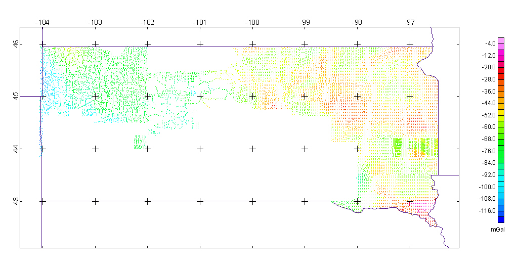
SDGS / USGS Gravity Survey - 1980,1987-1992
![]()
Principal facts available in listing form with station elevations in feet or meters.
Digital data file available in ASCII format
![]()
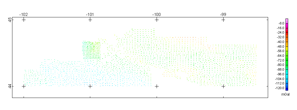
Edcon Inc. Contract Survey - 1988
![]()
Principal facts available in listing form with station elevations in feet or meters.
Digital data file available in ASCII format
![]()
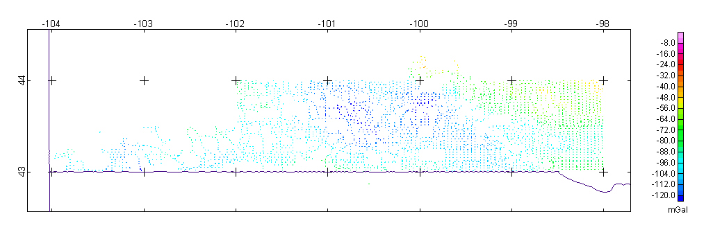
Klasner / W. Illinois Univ. Survey - 1986
![]()
Principal facts available in listing form with station elevations in feet or meters.
Digital data file available in ASCII format
![]()
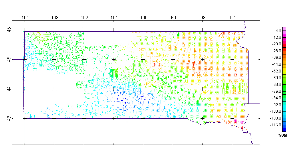
Total Coverage of the 3 Surveys
![]()
| AccessibilityFOIAPrivacyPolicies and Notices | |
| |
|