 |
|
|
||||
| OFR 01-0429: World Trade Center USGS Ferric-Ferrous Map |
| About USGS / Science Topics / Maps, Products & Publications / Education / FAQ |
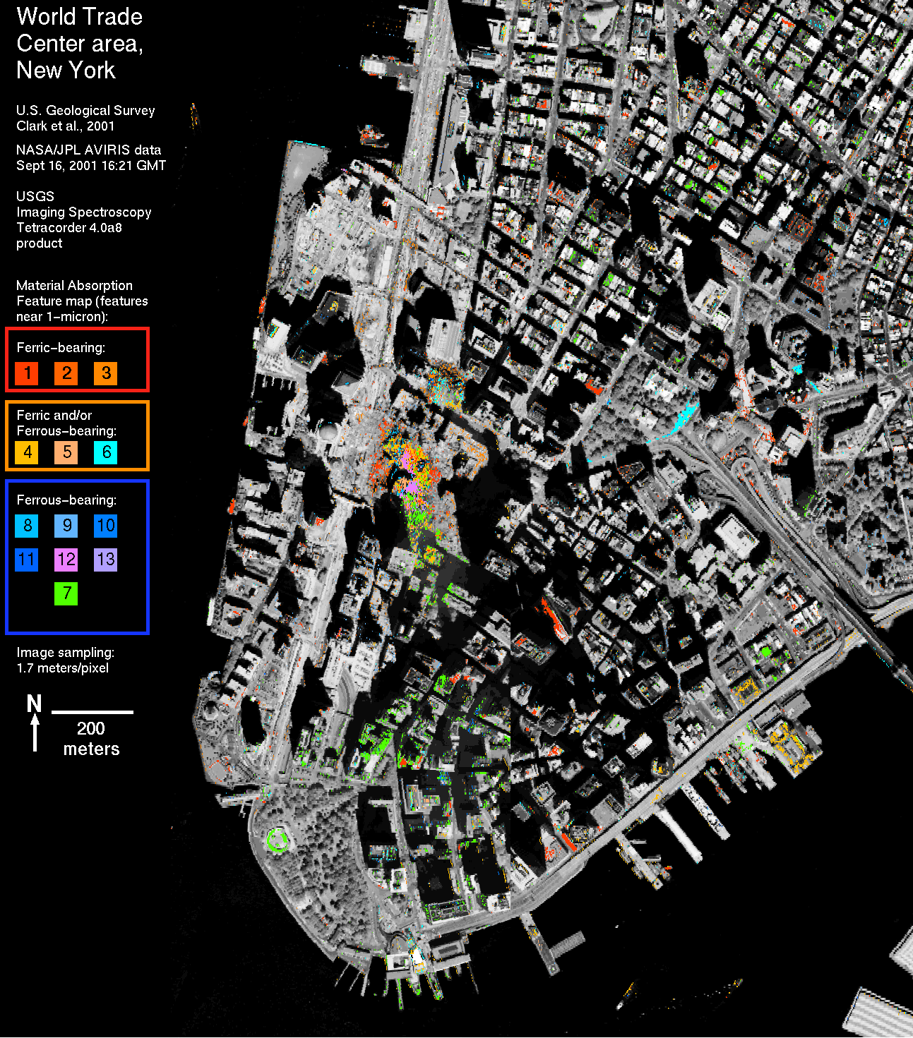
The images on this page (Iron Figure 1, 2) show locations of materials with ferric and ferrous absorption features. These materials/minerals may include common building materials; therefore, the map may include materials in buildings not associated with the World Trade Center (WTC) collapse. While the minerals mapped in any one location may or may not be associated with the WTC event, a pattern is seen that shows the distribution of materials related to the WTC collapse. This is because the debris from the collapse tends to appear contiguous near the WTC or in patches unrelated to the layout of roads and buildings. Building materials that map with sharp boundaries as roads and building shapes may not be WTC debris.
Fe-bearing materials occur in the WTC area and appear to be distributed in and around the collapse zone. Materials that were mapped show absorption features indicative of both ferric (Fe3+) and ferrous iron (Fe2+). Many minerals have similar ferrous absorptions, so maps show only the presence of Fe-bearing minerals and not specific mineralogy. In the maps below, the ferric and ferrous materials are identified only by numbered color. Pixels mapped as each numbered color indicate similar absorption position and shape and are likely similar in composition, but that composition is not generally a unique identifier of mineralogy.
The ferric absorptions are interpreted to be due to hematite (Fe2O3 - iron rust), or goethite (FeOOH). The red coatings on iron beams seen in news reports and by are field team are consistent with hematite or goethite.
Fe-bearing minerals are common in the aggregate in concrete. The Fe-absorptions appear in spectra of the debris samples and are prominent in spectra of the concrete debris. To see laboratory spectra of the dust and debris samples, CLICK HERE.
The map shows an asymmetric distribution of debris that extends to the SSE of the site. Similar distribution patterns are seen on the debris map (see previous section Dust and Debris Plume Map.) and the vibrational absorption map (next section), indicating a consistent finding of asymmetric distribution. Iron Figure 2 is the same as Iron Figure 1 but without the grey-scale image background. The debris pattern is more obvious without the background.
The asymmetry in the iron-bearing materials map may be related to the asymmetry in the asbestiform minerals map. The AVIRIS data and the laboratory analyses of the field samples indicate a lower abundance of chrysotile in the the southern direction from the WTC, the same direction of the increase in iron-bearing materials. The implications of this distribution will be explored in the Integration of results and conclusions section, below.
 Larger 1477 KB image Iron Figure 1a. Ferrous, ferric iron absorption features map. |
 Larger 526 KB image Iron Figure 1b. Ferrous, ferric iron absorption features map, same as at right, but zoomed in to lower Manhattan. |
 Larger 153 KB image Iron Figure 2a. Ferrous, ferric iron absorption features map, without the image background so the mapped materials are easier to see. |
 Larger 65 KB image Iron Figure 2b. Ferrous, ferric iron absorption features map, same as at right, but zoomed in to lower Manhattan. |
NEXT PAGE of Report: Clays and other Materials Map
Back to document Table of Contents
For further information, contact:
Dr. Roger N. Clark
[email protected]
| AccessibilityFOIAPrivacyPolicies and Notices | |
| |
|