|
|
|
||||
| OFR 01-0429: World Trade Center USGS Thermal |
| About USGS / Science Topics / Maps, Products & Publications / Education / FAQ |
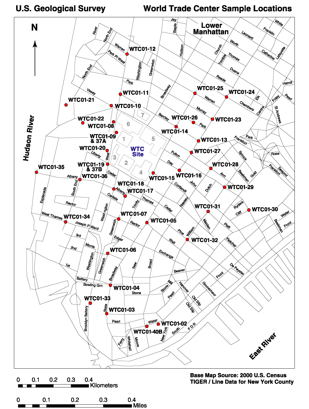
A 2-person USGS crew collected grab samples from 35 localities within a 0.5 - 1 km radius circle centered on the World trade Center site on the evenings of September 17 and 18, 2001 (see sample collection map, below). This same crew also carried out on-the-ground reflectance spectroscopy measurements during daylight hours to calibrate Airborne Visible /Infrared Imaging Spectrometer (AVIRIS) remote sensing data.
Many of the streets bordering the collection locations were cleaned or were in the process of being cleaned at the time of sample collection. Given this limitation, collection of dust samples was restricted to undisturbed window ledges, car windshields, flower pots, protected areas in door entry ways, and steps. Occasionally, samples were collected from the sidewalk adjacent to walls that were afforded some degree of protection from the elements and cleanup process. In many cases the samples formed compact masses suggestive of having been dampened by rain and having dried in the intervening 3 - 4 days. Two samples of an insulation coating (WTC01-8 and WTC01-9) were collected from steel girders recently removed from the debris pile of the WTC. Samples were gathered by nitrile-gloved hand and put into doubled plastic sample bags (sample bag in another sample bag). Initially, Global Position Satellite (GPS) locations were collected for the sample collection locations, but this approach was abandoned because of difficulty in acquiring a satellite signal between tall buildings. Instead, sample locations were identified using road intersections where road signs remained intact. All but two of the samples were collected outdoors and had been subjected to wind and water during a rain storm the night of September 14. One sample (WTC01-20) was collected indoors near the gymnasium in the World Financial Center directly across West Street from the World Trade Center. Samples of concrete (WTC01-37A and WTC01-37B) were collected from the WTC debris at the same location as WTC01-9. A sample of dust (WTC01-36) blown by the collapse into an open window of an apartment located 30 floors up and 0.4 km from the center of the WTC site was also acquired a few days later.
For further information, contact:
Dr. Gregg A. Swayze
gswayze@usgs.gov
or
Todd Hoefen
thoefen@usgs.gov
SL Figure 1. Sample location map.
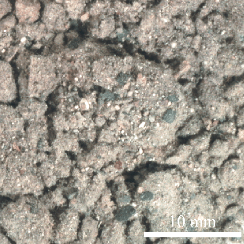
SL Figure 2. Optical image of dust and debris collected 0.3 km from ground zero (sample WTC01-27).
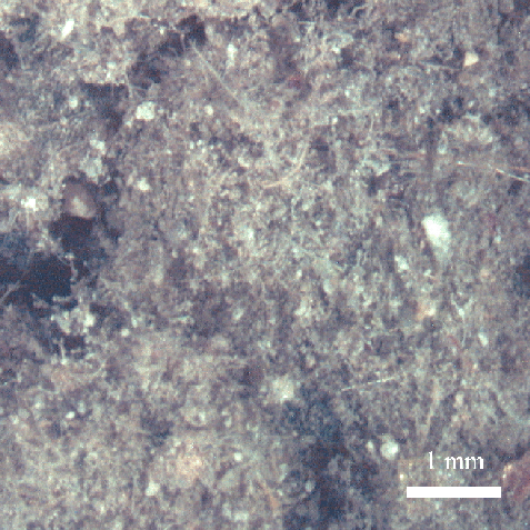
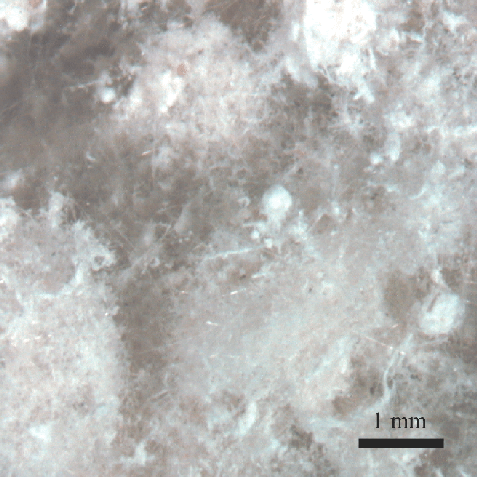
SL Figure 3. High magnification optical image of dust and debris collected 0.3 km from ground zero (sample WTC01-27). Most of the fibers seen in the image are probably glass fibers (e.g. from rock wool or fiberglass insulation) with a probable trace of chrysotile asbestos as detected by X-ray diffraction in this sample.
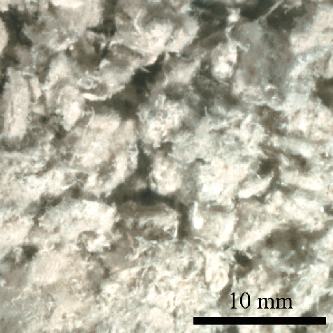
SL Figure 4. Optical image of an insulation coating collected from a steel beam removed from
the WTC debris pile (sample WTC01-8).
This insulation contains up to 20 volume % chrysotile asbestos.
SL Figure 5. High magnification optical image of an insulation coating from a steel beam
removed from the WTC debris pile (sample WTC01-8).
This insulation contains up to 20 volume % chrysotile asbestos.
NEXT Section of Report: Laboratory Studies of Samples
Back to document Table of Contents
| AccessibilityFOIAPrivacyPolicies and Notices | |
| |
|