FLOWS IN THE MOJAVE RIVER
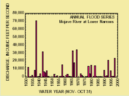
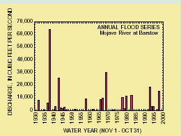
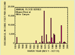
The Mojave River has its headwaters in the San Gabriel and San Bernardino Mountains of the Transverse Ranges of Southern California. The drainage areas at the long-term gaging stations are 513 mi² at Lower Narrows near Victorville, 1,290 mi² at Barstow, and 2,121 mi² at Afton Canyon. The river has a highly variable annual flood series, with some years having either base flow or zero discharge and other years having floods as high as 70,600 ft³/s. At left, the annual flood series, or largest peak discharge for each year, for three gages are given with the water year redefined to merge the effects of early fall tropical cyclones or cutoff lows into the previous year's record. Small floods and gaps in the gaging record cannot be resolved on these graphs, and Lower Narrows and Afton Canyon have perennial flow that also cannot be resolved on these graphs. The largest flood in the gaging record occurred in 1938, which was not an El Niño year; other years with large floods include 1891, 1905, and 1916, all of which were all El Niño years. In recent decades, the relation between flooding and El Niño has strengthened, with large floods in 1978, 1983, 1993, and 1998. The Mojave River only flows continuously from its source to its terminous in the Silver Lake Playa during these years.
The Mojave River and its tributaries have three dams that store water and provide some flood control for the reaches in the Mojave Desert (see map at on first page). The Mojave River Forks Reservoir and Silverwood Lake reservoir, both completed in 1971, likely attenuate flood peaks, although they have no effect on annual runoff volume (Lines, 1996). The presence of these reservoirs may be the reason why the size of floods appears to have declined in the latter part of the 20th century, although this decline also could be the result of climatic fluctuations. Lake Arrowhead reservoir, built in 1922, provides only minimal flow regulation.
Artificial discharges to the Mojave River have had local effects on riparian vegetation. Water circulated through fish hatcheries, as well as municipal effluent, is released into the river in varying amounts in the reaches above and below Victorville. Of lesser significance is water imported from the California Aqueduct that is stored in Silverwood Lake and released into the Mojave River, and water released from the Mojave Water Agency's Morongo Basin Pipeline 5 miles below the Mojave River Forks Reservoir (Lines, 1996). Although base flow and smaller annual floods recharge water to the alluvial aquifer along the Mojave River, larger floods play a greater role in maintenance of the riparian ecosystem. Germination of riparian species occurs in the wet sediments deposited during floods, and the sequence of floods, as well as the amount of time between them, determines whether establishment occurs. Large floods also supply a greater quantity of water to trees on the distal margins of floodplains, aiding their survival. These floods also destroy smaller plants, and lateral channel change may undercut larger trees. Significant floods have occurred about every 5 years in recent decades and may have contributed to the increases in riparian vegetation in some reaches.
