Open-File Report 02-100
By
V.L. Rystrom, C.A. Finn and Trude V.V. King
Crustal Imaging and Characterization Team
High resolution aeromagnetic
data for the Santa Cruz basin - Patagonia Mountains region of south-central
Arizona (USGS, 2000) can be combined with geologic mapped regions to reconfirm
known geologic features, extend known features, and suggest new possibilities.
These include mapping of lava flows, mapping of igneous intrusions, mapping
of faults, and the mapping of basement rocks which lie beneath sediments.
The processed maps of interest for a geologic interpretation include the
reduced-to-the-pole magnetic map (Phillips, Plate 3), the depth estimate
by the horizontal gradient method (Phillips, Plate 6), and the basin depth
estimates map (Phillips, Plate 16).
Maps:
Several maps have been produced for this report. Below is a list containing links to each map. Each map will be discussed in the text.
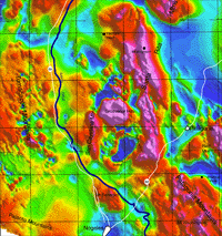
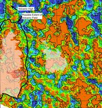
Below (figure 1) is the
reduced to the pole aeromagnetic map (Phillips) with place names, highways
and the anta Cruz River. Highway 89 runs through the Santa Cruz River Basin
alongside the seasonal Santa Cruz River. Click on image to view larger
version with location coordinates. There is a positive correlation between
the labeled mountains, hills and buttes and the magnetic highs.
|
|
|
|
Figure 1: Reduced to the pole aeromagnetic map with place names,
highways and Santa Cruz River information. Click to see larger version |
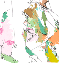
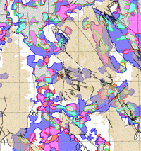
Figure 2: Igneous geology with faults. Click to see larger version. |
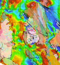
Figure 3: Reduced to the pole aeromagnetics with faults overlain
by geology. Click to see larger version. |
The geology in the region is complex reflecting various episodes of igneous intrusion, volcanism, and faulting ranging in age from Precambrian to Tertiary. Sedimentary rocks range in age from Cretaceous to the Present. Figure 2 is a digitized version of Drewes (1980) Tectonic Map of Southeast Arizona. Only igneous and volcanic rocks and faults have been represented, as these are the only likely candidates for producing the magnetic anomalies. Faults are dashed where concealed or inferred. Figure 3 shows the overlay of these units on the reduced-to-the-pole aeromagnetic map.
Lava Flows
|
|
|
|
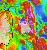
Figure 4: Reduced-to-the-pole aeromagnetics overlain by Tertiary
volcanic outcrops. Black line indicates the estimated extent of the volcanic
flows of the Tumacacori Mountains. Click to see larger version. |
Figure 5: Minimum magneticsource depth estimates overlain by volcanic
outcrops. TheBlack line indicates the estimated extent of the volcanic
flows of the Tumacacori Mountains. Click to see larger version. |
Figure 6: Basin estimates overlain by faults and igneous geology. Click to see larger version. |
Comparison (figure 5) of the location of the Tertiary volcanic flows with the minimum magnetic source depth estimates (Phillips, Plate 16), shows that the surficial volcanic rocks correlate well with the depth estimate range of 0 to ~ -50 m. North and east of the exposed volcanic rocks, the positive magnetic anomalies are still present (Figure 4) but at great depth (Figure 5), indicating that the magnetic volcanic rocks underlie the sediment cover.
Figure 6 shows the relation
between the Tertiary flows in the Tumacacori Mountains and the basin estimates
map (Phillips, Plate 16). The grey Tertiary extrusive rhyolitic flows correlate
with the white area where all three analytic basin depth tools suggest
a basin depth above 200 meters. The extent of the estimated flows (black
line) mostly lies within this white region, suggesting that the
volcanic rocks are generally less than 200 meters deep.
Igneous Intrusions
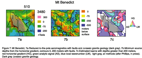
Mt. Benedict, north of Nogales, (Figure 1) is composed of Jurassic granite which produces a magnetic high (Figure 7a). Faults bound the granite on its east and south sides (A) and also mark the termination of the magnetic high. The western side of the granite is bounded by a fault (B) that does not mark the termination of the magnetic high (Figure 7a). This suggests that B is a low angle fault and that the pluton continues to the west beneath the sediment cover. Based on the horizonatal gradient depth estimates (Phillips), a basin may exists just west side of the fault (Figure 7b). This could be a normal fault in the Jurassic granite caused by extension. (Note: the Santa Cruz River flows along the fault to the east of Mt. Benedict.)
|
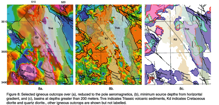
Over the Santa Rita Mountains, a high amplitude positive
anomaly correlates with Cretaceous diorite (Kd in Figures 8a-c). A similar
anomaly can be observed to the east and north-east over an area covered
by volcanic sediments (Trvs in Figures 8a-c.). This volcanic sedimentary
unit does not seem to correlate with the magnetic high. Given the high
amplitude and steep gradient marking the the eastern edge of the anomaly,
we suggest that the Cretaceous diorite (or some other igneous unit) lies
below the volcanic sediment and deepens eastward. This agrees with depth
estimates (Figures 8b) and inferred locations of basins (8c; Phillips,
plate 16) which place the source between ~ -350 meters to -1650 meters
(see Figure 7b for depth scale).
|
Faults
|
|
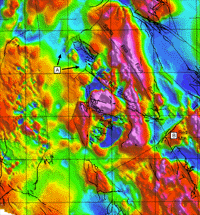
Figure 9: Reduced to the pole aeromagnetics with faults. Click to see larger version. |
Faults often produce steep gradients on the magnetic maps. In the case of the Salero Fault in the Santa Ritas, the fault is mapped northwest to the point where it is covered by sediments. From the aeromagnetic map (Figure 9) it appears that this fault can be extended half again its length to the northwest (A, Figure 9).
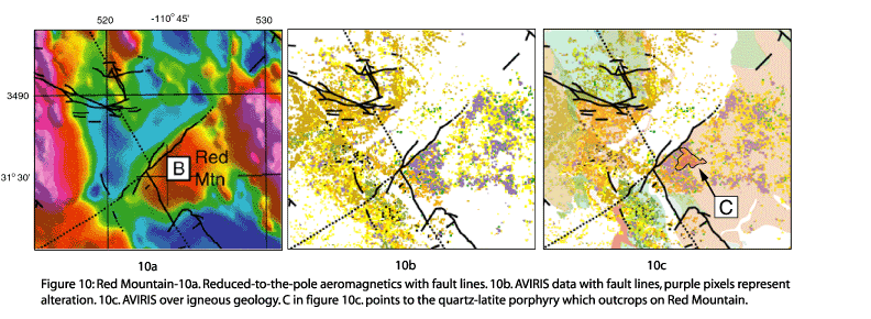
A good example of a steep magnetic gradient corresponding to a mapped fault is found northwest of Red mountain (B, Figure 9). Most mapped faults in this region do not produce steep magnetic gradients, either because they do not offset magnetic rocks (such as faults in sediments) or there is no magnetic contrast across the fault . The fault at B can also be seen using Airborne Visible/Infrared Imaging Spectrometer (AVIRIS) data which image minerals based on their radiance spectra. The fault terminates altered areas (Na40Alun400, purple pixels, Figure 10b). The fault also juxtaposes mapped Tertiary Rhyolite-Andesite Lava flows (pink, Figure 10c) with sedimentary rocks. Secondary magnetite related to alteration associated with a porphyry intrusion (C in Figure 10c.) produces the observed magnetic high (B, Figure 10a).
|
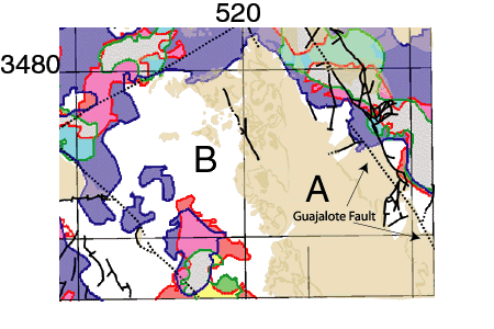
Basins
Jurassic granite, Quartz
Monzonite and Pinal Schist crop out on the west side of the Guajalote Fault
in the Patagonia Mountains (Figure 2). East of the fault occur Triassic
and Cretaceous sedimentary rocks and a Jurassic rhyolitic tuff. A high-amplitude
positive magnetic anomaly correlates with the outcrops of granite (Figure
3). The positive anomaly extends well to the east and west of the outcrop,
suggesting that the Jurassic igneous rocks extend well underneath the sediments
which cover the Patagonia Mountains. Comparison of the outcrop and the
location of basins (Figure 11) shows that the outcrop (A, Figure 11) correlates
with an area of thin (< 200 m) or no sediment cover. The igneous rocks
may continue under the area of thin sediment cover to the west (B).
|
| Figure 11: Igneous geology over basins with depths greater than 200 meters. |
References:

![]() U.S. Department of the Interior |
U.S. Geological Survey
U.S. Department of the Interior |
U.S. Geological Survey
URL: http://pubsdata.usgs.gov/pubs/of/2002/0100/intro.html
Page Contact Information: GS Pubs Web Contact
Page Last Modified: Wednesday, 07-Dec-2016 19:25:57 EST
