
U.S. Geological
Survey
Open-File Report 02-105 Online Version 1.0
[Approved for publication 3/01/02]
Coalbed Methane Production in the Appalachian Basin
By Robert C. Milici
|
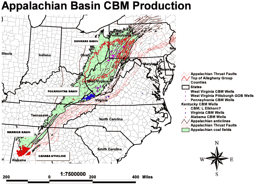
Figure 1. The Appalachian Basin in the eastern United States, illustrating major coalbed methane plays (Dunkard, Pocahontas, and Warrior Basins).
[Click on image for larger version] |
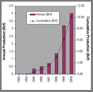
CBM development may be regarded as mature in the southern Appalachians where production in Alabama is relatively constant at about 110 Billion cubic feet (Bcf) annually. There is still opportunity for additional growth in the Pocahontas Basin, where Virginia's annual production has recently exceeded 50 Bcf. In addition, opportunities are emerging for producing the large, diffuse CBM resources in Pennsylvania, northern West Virginia, and Ohio as additional wells are drilled and technology improves.
Coalbed methane reservoirs commonly occur within their own source rocks (coal) where methane is generated by biogenic or thermal maturation processes that affect the coal macerals. The methane is adsorbed onto the surfaces of pores and fractures of various sizes within the coal bed, and from there may escape into the atmosphere at natural exposures or migrate into production drill holes or mines that have penetrated the formation. The gas produced from coal beds is almost entirely methane, commonly with small amounts of other hydrocarbons, hydrogen, carbon monoxide, carbon dioxide, and nitrogen. Gas obtained from underground mines may contain a considerable amount of gas other than methane.
Almost all wells drilled into methane-bearing coalbed reservoirs produce some gas, regardless of the structural position of the coalbed at any given location. The gas, however, exhibits little tendency to segregate from formation waters and the associated water commonly serves as an effective seal. Where present, formation waters are removed by pumping as a CBM field is developed. Removal of the water reduces the pressure within the reservoir and allows the methane to escape from the coal and into the well bore. In general, coalbed methane fields, which were defined by separate discoveries, tend to "grow together" or merge as development progresses, so that boundaries between fields become obscure as they combine to form large, tabular continuous accumulations that may persist laterally over several counties.
In assessing the coalbed methane resources of the nation, Rice (1995) identified three regional plays in the northern and central parts of the Appalachian Plateaus Physiographic Province - a northern Appalachian Basin syncline play, a northern Appalachian Basin anticline play, and a central Appalachian play. The northern Appalachian Basin anticline play was defined as occurring structurally above the water table and the syncline play as occurring below the water table in these folded rocks (Patchen and others, 1991). Rice (1995) reported 10.48 Trillion cubic feet (Tcf) as technically recoverable gas for the syncline play, 1.07 Tcf for the anticline play, and 3.07 Tcf for the central Appalachian Basin play. In addition, he assessed 2.3 Tcf of technically recoverable undiscovered CBM resources from the Warrior Basin in the southern part of the Appalachian Basin, and 0.25 Tcf from the Cahaba coal field, which lies adjacent to the Warrior Basin within the folded and faulted southern Appalachian Valley and Ridge Province.
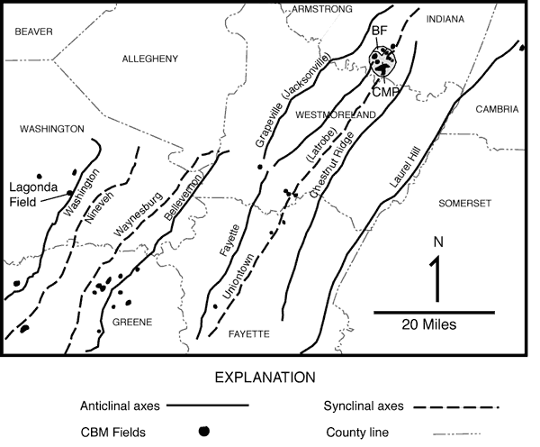
Subsequent drilling and multiple completions within stacked coalbed reservoirs (fig. 3), however, indicates that there is not a strict relationship between the location of CBM fields and pools and geologic structure in Pennsylvania, so that the definition of assessment units location on anticlines or synclines (Rice, 1995) is not valid everywhere (fig. 2, e.g. Campus Mill pool) (Bruner and others, 1998).
|

|
|
|
Figure 2. Location of CBM fields in southwestern Pennsylvania (Adapted from Markowski, 1998). BF, Blairsville Field; CMP, Campus Mill Pool.
[Click on image for larger version] |
Figure 3. Pennsylvanian stratigraphic nomenclature in the northern part of the Appalachian Basin (Showing approximate stratigraphic position of Elkhorn equivalents in Eastern Kentucky).
[Click on image for larger version] |
|
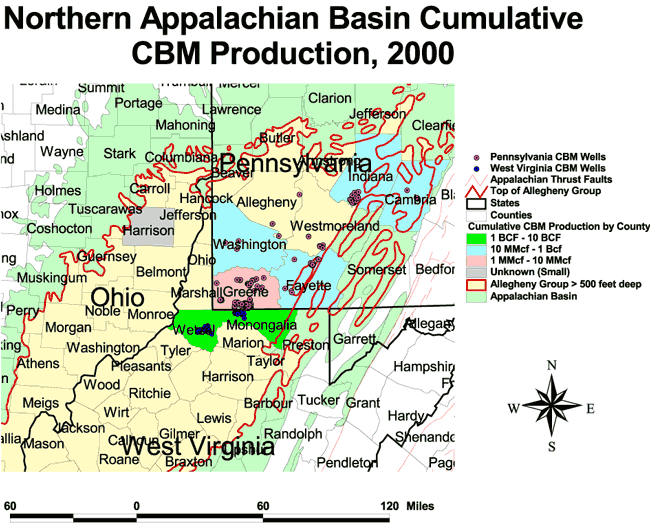
Figure 4. Coalbed methane (CBM) fields in the northern part of the Appalachian Basin.
[Click on image for larger version] |
The Blairsville field is the most significant commercial coalbed methane field in Pennsylvania. In this field, CBM is produced from several coal beds commonly completed over a vertical interval of 250 feet in wells that include the Bakerstown, Brush Creek, Upper and Lower Freeport, Upper, Middle, and Lower Kittanning, and the Clarion and Brookville coal beds. Markowski (1998) points out that the Allegheny Group, which contains the Brookville, Clarion, Lower, Middle, and Upper Kittanning, Lower and Upper Freeport coalbeds (fig. 3), is the stratigraphic interval that is most likely to yield commercial quantities of gas in Pennsylvania, as well as in northern West Virginia and Ohio.
Because the amount of coalbed methane contained within a coal bed commonly increases with the depth of the coal bed beneath the surface and because commercial quantities of CBM generally occur below 500 feet of overburden, the area where Allegheny Group coal beds may have sufficient cover to produce commercial quantities of gas occurs generally where it is overlain by the Conemaugh Group (figs. 3, 4). Pennsylvania CBM production is shown in Table 1.
|
Table 1. Cumulative coalbed methane production in the Appalachian Basin (Source of data: Alabama State Oil and Gas Board, 2000; Kentucky Division of Oil and Gas 2001; Markowski, 2001; Virginia Center for Coal and Energy Research, 2001; and West Virginia Geologic and Economic Survey, 2001). Mcf = thousand cubic feet; CBM = Coalbed methane.) |
||||
|
|
||||
| State | County | Date |
No. Currently Producing Wells |
CBM Cumulative Production (Mcf) |
|---|---|---|---|---|
|
|
||||
| Alabama | Greene | 6/30/01 | 0 | 99,565 |
| Bibb | 6/30/01 | 0 | 874 | |
| Hale | 6/30/01 | 0 | 111,543 | |
| Jefferson | 6/30/01 | 496 | 158,253,168 | |
| Pickens | 6/30/01 | 0 | 1,873 | |
| Shelby | 6/30/01 | 0 | 3,954,931 | |
| Tuscaloosa | 6/30/01 | 2,633 | 1,072,173,204 | |
| Walker | 6/30/01 | 66 | 10,455,347 | |
| Subtotal | 3,195 | 1,245,050,505 | ||
|
|
||||
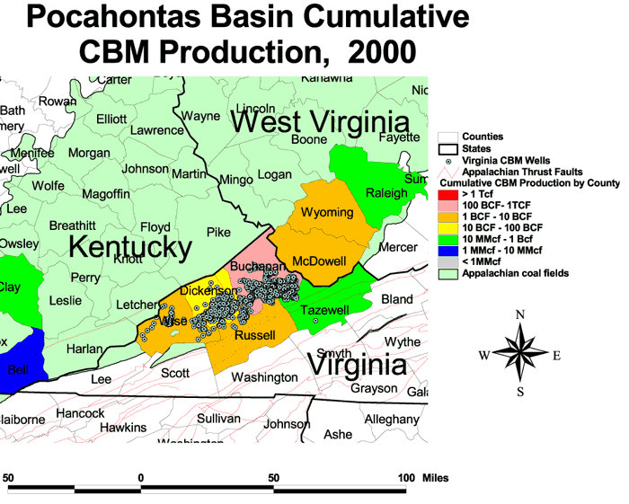
| Virginia | Buchanan | 1999 | 1,107 | 199,433,000 |
| Dickenson | 1999 | 373 | 44,208,000 | |
| Russell | 1999 | 33 | 4,521,000 | |
| Tazewell | 1999 | 71 | 1,001,000 | |
| Wise | 1999 | 62 | 3,477,000 | |
| Subtotal | 1999 | 1,646 | 252,641,000* | |
|
|
||||
| West Virginia | McDowell | 2000 | 37 | 2,242,168 |
| Monongalia | 1999 | 21 | 1,119,744 | |
| Raleigh | 1999 | 2 | 667 | |
| Wyoming | 2000 | 55 | 7,919,028 | |
| **Wetzel | 1988 | 0 | 2,096,862 | |
| Subtotal | 115 | 13,378,469 | ||
|
|
||||
| Pennsylvania | Cambria | 2001 | 2 | 52,571 |
| Fayette | 2001 | 7 | 42,915 | |
| Greene | 2001 | 75 | 9,745 | |
| Indiana | 2001 | 72 | 717,468 | |
| Washington | 2001 | 1 | 993,257 | |
| Subtotal | 157 | 1,815,956 | ||
|
|
||||
| Kentucky | Bell | 1999 | 2 | 4,328 |
| Clay | 1999 | 3 | 31,193 | |
| Leslie | 1999 | |||
| Subtotal | 35,521 | |||
|
|
||||
| Appalachian Basin total | 5,113 | 1,512,921,000 | ||
|
*Includes est. production from '91, '92 **Big Run Field only |
||||

|
|
||
|
Figure 5. Abandoned anticlinal CBM fields in the northern part of the Appalachian Basin (Adapted from Patchen and others, 1991). Contours are elevations above sea level, in feet.
[Click on image for larger version] |
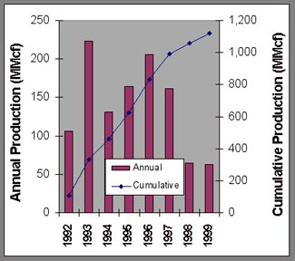
Figure 6. CBM production, Monongalia County, West Virginia (Pittsburgh gob, 18 wells) (West Virginia Geologic and Economic Survey, 2001). |
At present, coalbed methane is produced from about 21 wells in Monongalia County in northern West Virginia (fig. 4) that are drilled into the gob of an underground mine in the Pittsburgh coal bed. Production from this field commenced in 1990, and in recent years has declined from more than 223 MMcf from 7 wells in 1993 to about 62.5 MMcf in 1999 (West Virginia Geological and Economic Survey, 2001) (fig. 6).
In Ohio, Wolfe (1997) reported a flow of 300 to 500 Mcfd of methane from Vent #5 (originally a gob drainage well) at the Nelms-Cadiz Portal underground mine complex in Harrison County. In 1996, the well produced 47.5 MMcf in 61 days, in 1997 it produced 47.5 MMcf, and in 1998 it produced 56.5 MMcf in six months on line (Steve O'Pritza, Ohio Division of Oil and Gas, verbal communication 6/2000). The mine is reported to be in coal bed No. 6A (Lower Freeport). Gas from this vent is about 91 percent methane and is used at the mine to run several internal combustion engines. Since 1996, 16 wells have been permitted for coalbed methane exploration in Harrison County, Ohio. Of these, four are producing, two more are completed and are not yet producing, one has an active application, and the rest were not drilled as of June 2000.
|
Figure 7. Central Appalachian coalbed methane play. Tcf = trillion cubic feet; Bcf = billion cubic feet; MMcf = million cubic feet; CBM = coalbed methane.
[Click on image for larger version] |
|

|
|
| Figure 8. CBM production from the Bradshaw, Slab Fork, and Welch fields, McDowell, Wyoming, and Raleigh Counties, West Virginia (Beckley, Pocahontas coal beds, 84 wells), (West Virginia Geological and Economic Survey, 2001). | Figure 9. Virginia CBM production and cumulative production. (Production is currently from about 1646 wells), (Nolde and Spears, 1998, Virginia Center for Coal and Energy Research, 2001). |
In general, from six to ten coal beds (fig. 10), about 20 to 30 feet of total coal thickness, are selected and completed in each well and the gas production from each coal bed completed is commingled and produced from the well bore. The coal beds of the Pocahontas Formation are, in general, among the more productive of the Pennsylvanian sequence within the Pocahontas Basin. The Pocahontas Formation and its contained coal beds are truncated by a regional unconformity that cuts downward stratigraphically to the northwest, from Virginia into Kentucky, to where only younger formations and coal beds are preserved (Englund and Thomas, 1990). In recent years, several wells have been completed for CBM in Bell and Clay Counties, Kentucky. The wells produce from coal beds in the Pennsylvanian Breathitt Formation, probably from Lower Elkhorn coals (Brandon Nuttall, written communication, July, 2001). In 1999, five wells in this play produced about 35.5 MMcf of CBM (Kentucky Division of Oil and Gas, 2001). Most likely, effective CBM development in Eastern Kentucky will occur in the easternmost part of the state where the coal beds are 500 feet, or more, below the surface drainage.

|
Figure 10. Stratigraphic nomenclature of CBM fields in southwest Virginia, showing major coal beds completed for methane production*, and numbered in order of importance.
[Click on image for larger version] |
Rice (1995) estimated 5 Tcf as the in-place gas resources of the Central Appalachian Basin in southern West Virginia and southwestern Virginia. Subsequently, Nolde and Spears (1998) revised the in-place estimate upward to 6.7 Tcf for the Virginia part of the play.
|
|
|
|
Figure 11. Coalbed methane fields in Alabama (Alabama State Oil and Gas Board 2000). Tcf = trillion cubic feet; Bcf = billion cubic feet; MMcf = million cubic feet.
[Click on image for larger version] |
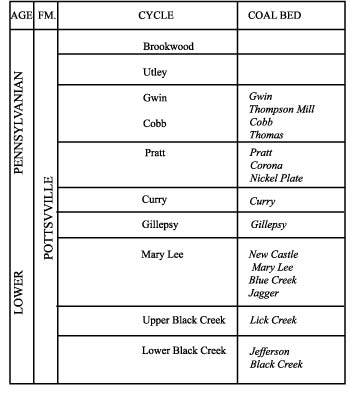
Figure 12. Stratigraphic nomenclature in Warrior Basin, Alabama (Pashin and Hinkle, 1997).
[Click on image for larger version] |
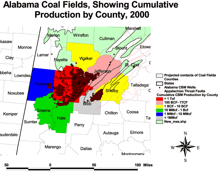
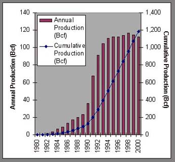
Alabama's coalbed methane production began in 1980, when the first permit for a coalbed methane well was issued by the State. Since then, a total of 21 coal bed degasification fields have been established, 19 in the Warrior coal field and two in the Cahaba coal field (Table 2) and more than 1 trillion cubic feet of gas have been produced (fig. 13). Over 5000 wells have been drilled for coalbed methane in Alabama and, of these, about 2900 wells remain in production. Wells commonly are completed in the Black Creek (7 feet cumulative coal thickness (CCT)), Mary Lee (12 feet CCT), and Pratt coal zones (6 feet CCT). In Alabama, annual production has exceeded 100 Bcf for the past several years, cumulative production has exceeded 1 Tcf, and reserves may exceed 3 Tcf (Alabama State Oil and Gas Board, 2000).
| Figure 13. Alabama coalbed methane annual and cumulative production (data courtesy of Jack Pashin, Alabama Geological Survey). |
|
|
Table 2. Coalbed methane production in Alabama, by field (Alabama State Oil and Gas Board, 2000). [The Gurnee and Scottsville fields are in the Cahaba syncline; all others are in the Warrior Basin.] |
|||||||
|
|
|||||||
| Field Name | County |
Total Area (sq.mi.) |
Date Established |
Total Wells |
Producing Wells* |
Monthly Production* (Mcf)** |
Cumulative Production* (Mcf)** |
|---|---|---|---|---|---|---|---|
|
|
|||||||
| Big Sandy Creek | Tuscaloosa | 13 | 4/11/90 | 85 | 50 | 86,191 | 5,633,082 |
| Blue Creek | Tuscaloosa | 139 | 6/24/88 | 562 | 430 | 1,241,535 | 177,245,251 |
| Boone Creek | Tuscaloosa | 1 | 3/2/90 | 5 | 0 | 0 | 57,734 |
| Brookwood | Tusc./Jeff. | 99 | 6/3/81 | 793 | 332 | 1,943,705 | 239,219,863 |
| Carroll's Creek | Tuscaloosa | 12 | 4/17/85 | 4 | 0 | 0 | 0 |
| Cedar Cove | Tuscaloosa | 138 | 10/24/83 | 593 | 503 | 1,696,066 | 204,933,520 |
| Deerlick Creek | Tuscaloosa | 57 | 12/15/83 | 278 | 267 | 605,269 | 91,456,247 |
| Gurnee | Shelby | 144 | 2/2/90 | 450 | 25 | 10,977 | 3,874,186 |
| Holt | Tuscaloosa | 15 | 9/28/82 | 57 | 50 | 205,594 | 26,480,243 |
| Little Buck Creek | Tuscaloosa | 18 | 8/21/92 | 14 | 0 | 0 | 336,708 |
| Little Sandy Creek | Tuscaloosa | 20 | 11/28/89 | 63 | 0 | 0 | 1,432,236 |
| Moundville | Gree./Hale/Tusc. | 103 | 5/29/90 | 290 | 0 | 0 | 369,896 |
| Oak Grove | Jeff./Tusc. | 265 | 5/29/90 | 934 | 516 | 1,144,359 | 169,473,397 |
| Peterson | Tuscaloosa | 12 | 1/19/84 | 85 | 60 | 260,623 | 33,455,208 |
| Pleasant Grove | Jefferson | 3 | 7/11/80 | 4 | 0 | abandoned | 264,719 |
| Robinson's Bend | Tuscaloosa | 109 | 5/25/90 | 492 | 394 | 671,278 | 76,450,886 |
| Scottsville | Bibb | 2 | 6/28/91 | 3 | 0 | abandoned | 583 |
| Taylor Creek | Gree./Tusc. | 11 | 1/30/92 | 20 | 0 | 0 | 105,412 |
| Thornton Creek | Tuscaloosa | 23 | 12/2/94 | 16 | 14 | 17,403 | 855,222 |
| White Oak Creek | Walk./Jeff./Tusc. | 87 | 5/5/89 | 303 | 255 | 1,621,643 | 45,257,264 |
| Wolf Creek | Tuscaloosa | 4 | 3/2/90 | 6 | 0 | 0 | 94,541 |
| TOTAL | 9,504,643 | 1,076,996,198 | |||||
|
|
|||||||
The northern part of the coal field in Alabama is underlain by a generally thinner coal-bearing stratigraphic section than that in the Warrior Basin to the south; less coal is mined; and the methane resources of the region have not yet been exploited (Pashin and Hinkle, 1997). The Cahaba coal field, which produces much less methane than the Warrior Basin, lies in an elongated, northeast-oriented synclinal trend within the folded and faulted Appalachian Mountains, about six miles to the southeast of the Warrior coal field (Pashin and others, 1995), (Fig 11). Methane production in the Cahaba Basin is from coal beds of the Pottsville Formation of Lower Pennsylvanian age.
Bruner, K. R., Oldham, A. V., Repine, T. E., Markowski, A. K., and Harper, J. A., 1998, Geological aspects of coalbed methane in the northern Appalachian coal Basin, southwestern Pennsylvania and north-central West Virginia: Pennsylvania Geological Survey Open File Report 98-13, 72 p.
Englund, K. J., and Thomas, R. E., 1990, Late Paleozoic depositional trends in the central Appalachian Basin: U.S. Geological Survey Bulletin 1839-F, 22 p.
Kentucky Division of Oil and Gas 2001, http://www.caer.uky.edu/kdmm/prod99.htm.
Lyons, P. C., 1998, The central and northern Appalachian Basin-a frontier area for coalbed methane development: International Journal of Coal Geology, v. 38, p. 61-87.
Markowski, A. K., 1998, Coalbed methane resource potential and current prospects in Pennsylvania: International Journal of Coal Geology, v. 38, p. 137-159.
Markowski, A. K., 2001, CBM Activities in Pennsylvania: Unpublished presentation, October, 31, 2001, to the Fall Session of the North American Coalbed Methane Forum, Morgantown, WV.
Nolde, J. E., and Spears, David, 1998, A preliminary assessment of in place coalbed methane resources in the Virginia portion of the central Appalachian Basin: International Journal of Coal Geology, v. 38, p. 115-136.
Pashin, J. C., Carroll, R. E., Barnett, R. L., and Beg, M. A., 1995, Geology and coal resources of the Cahaba coal field: Geological Survey of Alabama Bulletin 163, 49 p.
Pashin, J. C., and Hinkle, Frank, 1997, Coalbed methane in Alabama: Geological Survey of Alabama Circular 192, 71 p.
Patchen, D. G., Schwietering, J. F., Avary, K. L., and Repine, T. E., 1991, Coalbed gas production, Big Run and Pine Grove fields, Wetzel County, West Virginia: West Virginia Geological and Economic Survey Publication C-44, 33 p.
Rice, D. D., 1995, Geologic framework and description of coalbed gas plays, in Gautier, D. L., Dolton, G. L., Takahashi, K. I., and Varnes, K. L. (eds.) Results, methodology, and supporting data for the 1995 National Assessment of United States Oil and Gas Resources: U.S. Geological Survey Digital Data Series 30 [CD-ROM].
Sweet, P. C., and Nolde, J. E., 1999, Coal, oil, and gas, and industrial and metallic minerals in Virginia, 1998: Virginia Division of Mineral Resources Publication 153, 25 p.
Virginia Center for Coal and Energy Research, 2001, http://www.energy.vt.edu/.
West Virginia Geological and Economic Survey, 2001, WVGES Summary data and statistics, coalbed methane wells in West Virginia: http://www.wvgs.wvnet.edu/www/datastat/dtcm90s.htm.
Wolfe, M. E., 1997, Coalbed methane-an untapped energy resource in Ohio: Ohio Geology, Summer 1977: http://www.ohiodnr.com/geosurvey/oh_geol/97_summer/methane.htm.
U.S. Department of the Interior, U.S. Geological Survey
URL: https://pubsdata.usgs.gov/pubs/of/2002/of02-105/of02-105.html
For more information. contact Robert C. Milici (rmilici@usgs.gov)
Maintained by Eastern Publications Group
Last modified: 18:58:59 Wed 07 Dec 2016
Privacy statement | General disclaimer | Accessibility