| |  |  | | Lake Pontchartrain Atlas: | | | | | | | | | | | | | Environmental Overview |  | | | | | | | | | | | | | | | | | | | | | | | | | | | | | | | |  | | | | | | | | | | |  | Environmental Overview - Regional Description of the Lake Pontchartrain Basin Contributors: Penland, McCarty, Beall, Maygarden  | | Figure 2: Satellite image of the Lake Pontchartrain Basin. Click on the image for a larger version. | Lake Pontchartrain and its surrounding Basin constitute an estuarine ecosystem of national significance (Darnell, 1962; Houck et al., 1989). The Lake Pontchartrain Basin is a 12,173 km2 (4,700 mi2) watershed in southeast Louisiana and southwest Mississippi (Figure 2). Almost 1.5 million residents surround Lake Pontchartrain, making it the most densely populated area in Louisiana. The topography of the Basin ranges from more than 91 m (300 ft) above sea level in the rolling hills along the Louisiana and Mississippi state line to sea level throughout the coastal wetlands to more than 3 m (10 ft) below sea level in some areas of New Orleans (Figure 3). The northern half of the Basin is commonly referred to as the Florida Parishes (Autin et al., 1986). Many rivers drain the Florida Parishes, introducing fresh water into Lakes Maurepas, Pontchartrain and Borgne. The largest of these, the Pearl and Amite Rivers, have headwaters in Mississippi. The rivers have eroded and incised these uplands to form distinct river valleys. Lakes Maurepas, Pontchartrain and Borgne form a shallow brackish receiving basin for fresh water from the Amite, Tickfaw, Blind, Tangipahoa, Tchefuncte and Pearl Rivers, as well as Bayous Lacombe and Bonfouca. Fresh water is also introduced through regional drainage canals while salt water enters these lakes from the Gulf of Mexico via Mississippi Sound, Mississippi River Gulf Outlet ( MRGO ) and Chef and Rigolets Passes. The Mississippi River Deltaic Plain lies south of these lakes. 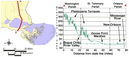 | | Figure 3: Topographic transect through Lake Pontchartrain Basin illustrates landscape diversity. | « Previous | Next » |
