Coastal & Marine Geology Program
>
Center for Coastal & Regional Marine Studies
> Environmental Atlas of Lake Pontchartrain
«
Return to Previous Page
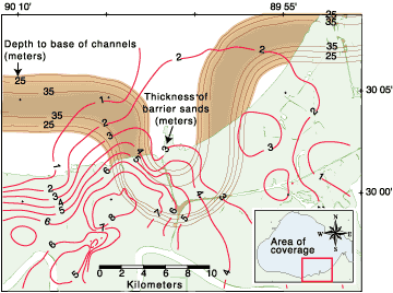
Figure 19:
Contour structure map showing depth to thalweg of the incised paleochannel (below mean sea level) and isopach of Pine Island barrier trend. Contours were generated from digitized HRSP interpretations and well cuttings.
«
Return to Previous Page
Coastal & Marine Geology Program
>
Center for Coastal & Regional Marine Studies
> Environmental Atlas of Lake Pontchartrain
email
Feedback
[an error occurred while processing this directive]