


 |
 |
U.S. Geological Survey
Open-File Report 02-281
Version 1.0.
|
|
|
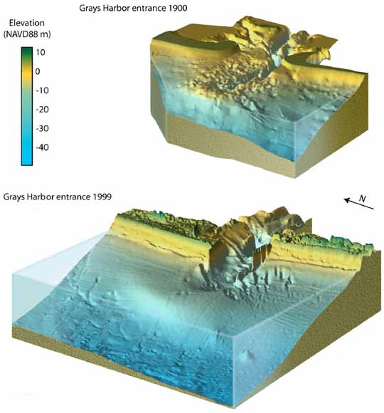
Top: Three-dimensional representation with perspective of the Grays Harbor entrance, circa 1900 and 1999. See Section 2 for details.
|
SUMMARY In this Open-File Report we present calculations of changes in bathymetric and topographic volumes for the Grays Harbor, Willapa Bay, and Columbia River entrances and the adjacent coasts of North Beach, Grayland Plains, Long Beach, and Clatsop Plains for four intervals: pre-jetty - 1920s (Interval 1), 1920s - 1950s (Interval 2), 1950s - 1990s (Interval 3), and 1920s 1990s (Interval 4). This analysis is part of the Southwest Washington Coastal Erosion Study (SWCES), the goals of which are to understand and predict the morphologic behavior of the Columbia River littoral cell on a management scale of tens of kilometers and decades. We obtain topographic Light Detection and Ranging (LIDAR) data from a joint project by the U.S. Geological Survey (USGS), National Oceanic and Atmospheric Administration (NOAA), National Aeronautic and Space Administration (NASA), and the Washington State Department of Ecology (DOE) and bathymetric data from the U.S. Coast and Geodetic Survey (USC&GS), U.S. Army Corps of Engineers (USACE), USGS, and the DOE. Shoreline data are digitized from T-Sheets and aerial photographs from the USC&GS and National Ocean Service (NOS). Instead of uncritically adjusting each survey to NAVD88, a common vertical land-based datum, we adjust some surveys to produce optimal results according to the following criteria. First, we minimize offsets in overlapping surveys within the same era, and second, we minimize bathymetric changes (relative to the 1990s) in deep water, where we assume minimal change has taken place. We grid bathymetric and topographic datasets using kriging and triangulation algorithms, calculate bathymetric-change surfaces for each interval, and calculate volume changes within polygons that are overlaid on the bathymetric-change surfaces. We find similar morphologic changes near the entrances to Grays Harbor and the Columbia River following jetty construction between 1898 and 1916 at the Grays Harbor entrance and between 1885 and 1913 at the Columbia River entrance. The inlets and inner deltas eroded and the outer deltas moved offshore and accreted. The adjacent coasts experienced accretion over alongshore distances of tens of kilometers. North of the Grays Harbor entrance along North Beach and north of the Columbia River entrance along Long Beach the shoreface and the beach-dune complex mainly prograded, whereas south of the Grays Harbor entrance along Grayland Plains and south of the Columbia River entrance along Clatsop Plains the beach-dune complex above -10 m NAVD88 prograded and the shoreface between approximately -30 m and -10 m NAVD88 eroded. In the decades following jetty construction, the rates of erosion and accretion at the entrances decreased and the centers of deposition along the adjacent coasts moved away from the entrances. The rates of change have decreased, suggesting the systems are approaching dynamic equilibrium. Exceptions to this behaviour are the accretion of the beach-dune complex of Long Beach, the erosion of Cape Shoalwater, and the northward migration of the Willapa Bay ebb-tidal delta during all intervals. The net shoreline advance of Long Beach increases from 0.28 m/yr in pre-jetty conditions to 3.78 m/yr during Interval 4. The erosion of Cape Shoalwater and the northward migration of the Willapa Bay ebb-tidal delta are related to the northern migration of the Willapa Bay North Channel. Volume changes at the Grays Harbor, Willapa Bay, and Columbia River entrances and the Columbia River estuary are balanced against losses and gains due to littoral transport and sand supply from the Columbia River. Based on these sediment balances, we infer the following pathways: sand that eroded from the inlets and inner deltas at the Grays Harbor and Columbia River entrances moved offshore and northward to accrete the outer deltas and the beaches to the north; sand from the south flank of the Grays Harbor delta and shelf along Grayland Plains moved onshore to accrete the beach dune complex of Grayland Plains and moved northward to maintain accretion of the outer delta and the beach-dune complex of North Beach; sand that eroded from the south flank of the Columbia River delta and shelf along Clatsop Plains contributed to the accretion of the beach-dune complex of Clatsop Plains and the Columbia River outer delta. The net volume change for Interval 1 and 3 at the Grays Harbor entrance and for Interval 1 at the Columbia River entrance is erosion, whereas the net change for the other intervals is accretion. For the entire CRLC, there is a net loss of 185 Mm3 for Interval 1, a net gain of 357 Mm3 for Interval 2, and a net gain of 187 Mm3 for Interval 3. These imbalances can be the result of incomplete bathymetric coverage of the bays and shoreface, uncertainties in the adjustments of vertical tidal datums, inconsistencies in the bathymetric data, and uncertainties in the sediment supply of the Columbia River. |
Download this report as a PDF document (6.8 MB)
For questions about the content of this report, contact Guy Gelfenbaum
|
Help |
PDF help |
Publications main page |
Western
Region Open-File Reports for 2000 |