
This report is preliminary
and has not been reviewed for conformity with U.S. Geological Survey editorial
standards or with the North American Stratigraphic Code. Any use of trade, product,
or firm names is for descriptive purposes only and does not imply endorsement
by the U.S. Government
Contents:
Introduction
Cruise Summaries
1998
1999
Data Processing
SEG-Y and Image Data
Positional Data
Data Display
Contacts
FGDC-compliant metadata
References
During June 1998 and April 1999, the U.S. Geological Survey (USGS) conducted two research cruises in the northern Gulf of Mexico to acquire high-resolution seismic reflection data across the upper and middle continental slope as part of an investigation of the seismic character, distribution, and potential effects of naturally-occurring marine gas hydrates and related free gas within the gas hydrate stability zone. Over 1600 km of two-dimensional multichannel seismic reflection profiles were acquired during these two cruises. The specific objectives of this investigation are (a) to produce high-resolution images of the gas hydrate stability zone; (b) to study the distribution and character of potential seafloor failures and their relationship to known and inferred gas hydrate deposits; (c) to look at systematic variations in subsurface structure in gas hydrate and non-hydrate areas; and (d) to estimate, if possible, the amounts of hydrates present within the gas hydrate stability zone. The multichannel profiles provide high-quality images with approximately 5 meters of vertical resolution and up to 2 km of penetration. This report gives an overview of the acquisition and data processing of the multichannel seismic reflection profiles and provides references and links to reports with more detailed information. Geologic interpretations of these seismic profiles regarding gas hydrate occurrence and distribution within the study areas of this investigation are given in Cooper and Hart (2002).
|
Available Data |
|
|
1998
|
1999
|
| Seismic image files (gif) | Seismic image files (gif) |
| Seismic SEG-Y files | Seismic SEG-Y files |
| Navigation file | Navigation file |
| Trackline map with line numbers | Trackline map with line numbers |
| Trackline map with line numbers and CDP numbers (larger scale) | Trackline map with line numbers and CDP numbers (larger scale) |
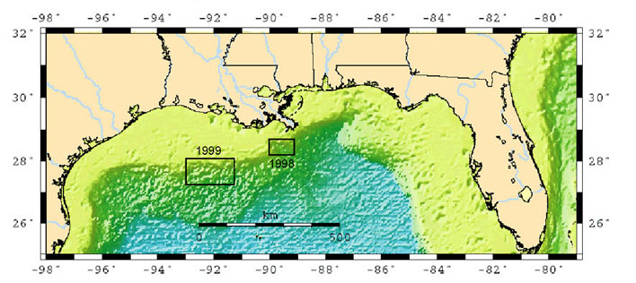 |
| Figure 1. Map showing location of the 1998 and 1999 cruises in northern Gulf of Mexico |
1998 (USGS Cruise ID: M1-98-GM)
The USGS and the University
of Mississippi Marine Minerals Technology Center (MMTC) collaborated on a 12-day
cruise in June 1998 in the Mississippi Canyon Region of the Gulf of Mexico,
collecting data in two areas on opposite flanks of the Mississippi Canyon. The
R/V Tommy Munro, owned by the Marine Research Institute of the University of
Southern Mississippi, was chartered for this cruise. A detailed summary of the
field operations and equipment is given in Cooper
et al. (1998). Several types of seismic data were acquired during this cruise,
including surface-towed high-resolution multichannel profiles (the subject of
this report), deep-towed boomer single-channel profiles, and ocean-bottom seismometer
data. A trackline map of the multichannel profiles acquired during the M1-98-GM
cruise is shown in figure 2.
The multichannel data acquisition
system used for the 1998 cruise consisted of a 24-channel hydrophone streamer,
a small air-gun or water-gun source, and a PC-based digital recording system.
The streamer was 240 meters in length with a 10-meter group interval (three
hydrophones per group), and was manufactured by Innovative Transducers, Inc.
(ITI) with solid-core construction and "thin-film" cylindrical hydrophones
of polyvinylidene fluoride (PVDF) plastic. There was a 30 meter source-to-first-channel
gap and the streamer was intended to be towed at a 1 to 3 meter depth although
there were no depth sensors or depth control system on the streamer. A problem
with a streamer connection caused the far 7 channels to be very noisy, and these
channels were eliminated during data processing. The source used was either
a 35/35 cubic inch dual-chamber GI air gun (lines 1-15) or a 15 cubic inch water
gun (lines 17-19 and 50-75). Line 16 was acquired using a larger 105/105 cubic
inch GI gun. The "injector" chamber of the GI gun is timed to discharge
a short time (typically 20-30 milliseconds) after the "generator"
chamber so as to suppress the bubble pulse and create an optimal signal. The
small GI gun was fired at a 14-or 15-second interval (approximately 30 meters
at our survey speed of 3.5 to 4 knots), the large GI gun at a 42 second interval
(approximately 90 meters), and the water gun fire interval was 5 seconds (approximately
10 meters). The data were digitized and recorded in SEG-D format with a Geometrics
Strataview data recorder; a compact, PC-based instrument with approximately
24-bit (120 dB measured) dynamic range. Field sampling interval was 0.25 millisecond
and field record length was 2 seconds plus up to 1.5 seconds of deep-water recording
delay. A differential Global Positioning System (GPS) system provided navigational
accuracy of 5 to 10 meters.
1999
(USGS Cruise ID: G1-99-GM)
The USGS conducted another
northern Gulf of Mexico seismic data acquisition cruise in April 1999 using
the Texas A&M University Research Vessel Gyre. This 13-day cruise was a
continuation of the USGS northern Gulf of Mexico gas hydrate study and was run
west of the 1998 cruise area in the Garden Banks and Green Canyon regions. (Cooper
et al., 1999) A trackline map of the multichannel profiles acquired during
the G1-99-GM cruise is shown in figure 3.
The multichannel data acquisition
equipment and parameters during G1-99-GM were the same as M1-98-GM except the
15 cubic inch water gun source was used on all lines. In addition, the recording
problem with the far 7 streamer channels was corrected.
The SEG-Y and gif image
files of the multichannel seismic data profiles (for
1998 and 1999 cruises) were
created using the following seismic data processing sequence. Note that the
SEG-Y files have no post-stack processing applied, but the gif image files have
a post-stack filter and balance. A noise-spike editing step was applied to the
1999 data to minimize high-frequency spikes created by the concurrent acquisition
of deep-tow boomer data (Huntec). The water gun data had specialized deconvolution
applied, as described in detail in Lee
et al., 2000.
|
Multichannel Data Processing Sequence |
|
| 1. | SEG-D input and resample to 0.5 millisecond |
| 2. | Trace edit |
| 3. | Geometry assignment |
| 4. | 50 Hz low-cut filter |
| 5. | Water-bottom mute |
| 6. | Deep-water recording delay correction |
| 7. | Spherical divergence correction |
| 8. | Noise-spike editing |
| 9. | FK filter |
| 10. | Deconvolution |
| 11. | Common midpoint (CMP) sort |
| 12. | Stacking velocity analysis |
| 13. | Normal move-out correction |
| 14. | Stack |
| 15. | SEG-Y output |
| 16. | 60-320 Hz bandpass filter |
| 17. | Whole-trace balance |
| 18. |
gif image file output |
The seismic reflection profiles
and associated data are provided with this report. The profile data are written
as files in SEG-Y exchange format (Barry and others, 1975).
Stacked multichannel air
gun profiles: the stacked SEG-Y data are written in 32-bit IBM floating point
format at a 0.5 millisecond sample interval; record length is 2.0 to 3.5 seconds
including up to 1.5 seconds of deep water recording delay. The EBCDIC header
for each file contains additional descriptive information as shown in tables
1 and 2.
SEG-Y
Data and gif images for Seismic-Reflection Profiles from M1-98-GM Cruise
SEG-Y Data and gif images for Seismic-Refection Profiles from G1-99-GM Cruise
Each profile is available
as a digital data file (SEG-Y format), and a low-resolution image (gif).
CAUTION:
SEG-Y files may be very large, and therefore long to download.
These ASCII files
contain columns listing line number, CDP number, latitude and longitude in decimal
degrees and UTM coordinates CDP stands for Common Depth Point and each seismic
trace along a profile has a unique CDP number and are located at 5 meter intervals.
Locations are listed for every 20th to 40th CDP along each profile. Interpolation
of locations between listed CDPs would be necessary to obtain coordinates for
every CDP. CDP locations are not listed in the SEG-Y seismic trace headers.
No software
is provided for preview or display of the SEG-Y, image or navigational data.
SEG-Y data can be displayed, printed or further processed using a variety of
seismic processing programs that run on UNIX, Windows and Macintosh systems.
A public-domain seismic processing package for Unix systems, SU, is available
via the Internet at: http://www.cwp.mines.edu/cwpcodes/.
Gif images of the seismic lines can be opened in any of numerous graphics packages.
Navigation files can be plotted using commercial GIS software such as ARC/INFO.
The Generic Mapping Tools (GMT), a public-domain mapping package for visualizing
geographic vector data on Unix systems, was used to create the trackline figures,
and is available via the Internet at: http://imina.soest.hawaii.edu/gmt/
For further
information regarding these datasets contact:
Patrick Hart (650) 329-5157 or Alan Cooper (650) 329-5160
U.S. Geological Survey
M/S 999 M/S 999
345 Middlefield Rd.
Menlo Park CA 94025
hart@usgs.gov or acooper@usgs.gov
Barry, K.M., Cavers, D.A., and Kneale, C.W., 1975, Recommended standards for digital tape formats: Geophysics, v. 40, p. 344-352
Cooper, A. K., Hart, P.E., Pecher, I., 1998, Cruise report for a seismic investigation of gas hydrates in the Mississippi Canyon region, northern Gulf of Mexico – Cruise M1-98-GM, U.S. Geological Survey Open-File Report 98-506, 25 p.
Cooper, A. K., Twichell, D., and Hart, P.E., 1999, A seismic-reflection investigation of gas-hydrates and sea-floor features of the upper continental slope of the Garden Banks and Green Canyon regions, northern Gulf of Mexico: Report for cruise G1-99-GM (99002), U.S. Geological Survey Open-File Report 99-570, 19 p.
Cooper, A. K., and Hart, P. E., 2002, High-resolution seismic-reflection investigation of the northern Gulf of Mexico gas-hydrate-stability zone, Marine and Petroleum Geology, in press.
Lee., M. W., Hart, P. E., and Agena W. F., 2000, Processing Strategy for Water-Gun Seismic Data from the Gulf of Mexico, U.S. Geological Survey Bulletin 2181
Suggested citation and version history
Download a free copy of the latest version of Adobe Reader.
|
Help |
PDF help |
Publications main page |
| Western Open-File Reports for 2002 |
| Geology | WesternCoastal and Marine Geology

![]() U.S. Department of the Interior | U.S. Geological Survey
U.S. Department of the Interior | U.S. Geological Survey
URL: https://pubs.usgs.gov/of/2002/of02-368/
Page Contact Information: Michael Diggles
Created September 12, 2002 (cad)
Page Last Modified: June 30, 2008 (mfd)