USGS Banner and Link to USGS Homepage


Aeromagnetic Surveys in the Anchorage, Iliamna, and Tyonek Quadrangles Alaska, A Website for the Distribution of Data

Back to Main page

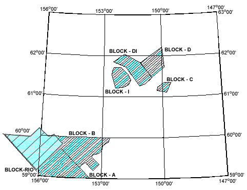
Location Map and Data Downloads


Survey Location Map Download Block C data Download Block D data DOwnload Block DI data Download Block  I data Download Block AB data Download Block Rio data

Click on the appropriate area of the map image above or the corresponding file name listed below to download the data in ASCII Text XYZ self-extracting ZIP format:

Block

Download File

Project Number
Contractor
Acquisition Dates
Line Spacing
Line Direction
Altitude
Total
AB

block_ab.exe (54,545 KB)

4243
SIAL
5/31/00-7/25/00
1600 m
135 deg
300 m AG
6634 miles
C
block_c.exe (5,165 KB)
4244
SIAL
6/22/00-7/27/00
800m
90 deg
150 m AG
670 miles
D
block_d.exe (21,858 KB)
4245
SIAL
6/15/00-6/22/00
800m
135 deg
150 m AG
2666 miles
I
block_i.exe (14,283 KB)
4246
SIAL
6/23/00-7/26/00
800m
90 deg
150 m AG
1934 miles
DI
block_di.exe (14,272 KB)
4247
SIAL
6/25/00-7/1/00
1600m
135 deg

300 m AG

1798 miles
RIO
block_rio.exe (32,615 KB)

Some documents on this website are PDF files. Adobe Acrobat Reader is required to view them. Download free Adobe Acrobat Reader to view PDF files at the Adobe web site or go to access.adobe.com for free tools that allow visually impaired users to read PDF files.

U.S.Department of the interior || U.S. Geological Survey
Crustal Imaging and Characterization Team
Current URL:
Last Modified: 26-Jan-2004 13:14
For more information about this report contact: Philip J. Brown II
USGS Privacy Statement || Disclaimer || Accessibility
Link to FirstGov