Generalized section showing the relation between the Chicot, Evangeline, and Jasper aquifers in the greater Houston area, Texas.
This report, prepared in cooperation with the Harris-Galveston Coastal Subsidence District, is the second annual report that depicts water-level altitudes in the Jasper aquifer in the greater Houston area (Montgomery County and parts of Harris, Grimes, Walker, and Waller Counties). The first water-level-altitude map for the Jasper aquifer in the area published by the U.S. Geological Survey (Coplin, 2001) depicts water levels in wells measured in spring 2000.
Water-level measurements used to prepare this map were obtained by steel tape, airline, and from reports of well operators. Most wells are pumped once daily, but some are pumped more frequently. Multiple measurements were made when wells were not being pumped; however, antecedent conditions and pumping status of nearby wells were not always known. Most measurements were made in January and February, the months when water levels usually are highest. For the 2001 map, 71 water-level measurements were used.
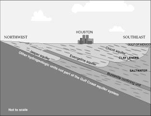
| The Jasper aquifer (in sediments of Miocene age) is the lowermost of the three primary aquifers of the Gulf Coast aquifer system. The Jasper aquifer is overlain by the Burkeville confining unit (in sediments of Miocene age), which in turn is overlain by the Evangeline aquifer (in sediments of Miocene and Pliocene age) and the Chicot aquifer (in sediments of Pleistocene and Holocene age). The hydrogeologic units dip from land surface southeastward at slight angles toward the Gulf of Mexico. The units thus crop out in bands approximately parallel to the coast. The Jasper aquifer outcrop, which comprises the oldest sediments, is the farthest inland of the aquifer outcrops. The Jasper aquifer in the greater Houston area thickens toward the coast from about 600 feet in the outcrop to about 1,000 feet at the base of fresh (less than 1,000 milligrams per liter dissolved solids) to slightly saline (1,0003,000 milligrams per liter dissolved solids) water (Baker, 1979). The Jasper aquifer can be separated into two parts on the basis of lithology (Popkin, 1971). The upper part, which composes 50 to 80 percent of the aquifer, consists of a massive sand; the lower part consists mostly of interbedded sand and clay. In the natural system, water recharges the Jasper aquifer in its outcrop, gradually moves downdip and discharges upward through the Burkeville confining unit. |
Generalized section showing the relation between the Chicot, Evangeline, and Jasper aquifers in the greater Houston area, Texas. |
Water-level measurements used to prepare this map were obtained by steel tape, airline, and from reports of well operators. Most wells are pumped once daily, but some are pumped more frequently. Multiple measurements were made when wells were not being pumped; however, antecedent conditions and pumping status of nearby wells were not always known. Most measurements were made in January and February, the months when water levels usually are highest. For the 2001 map, 71 water-level measurements were used.
 |
|
Approximate
water-level altitudes in the Jasper aquifer, Houston area, Texas, JanuaryFebruary
2001.
|
Baker, E.T., Jr., 1979, Stratigraphic and hydrogeologic framework of part of the Coastal Plain of Texas: Texas Department of Water Resources Report 236, 43 p.
Coplin, L.S., 2001, Water-level altitudes in wells completed in the Jasper aquifer, greater Houston area, Texas, spring 2000: U.S. Geological Survey Open-File Report 01147, 2 p.
Popkin, B.P., 1971, Ground-water resources of Montgomery County, Texas: Texas Water Development Board Report 136, 149 p.
University of Texas, Bureau of Economic Geology, 1968, Geologic atlas of Texas, Beaumont sheet: Austin, scale 1:250,000.
______1974, Geologic atlas of Texas, Austin sheet: Austin, scale 1:250,000.