COMPARISON OF STREAMFLOW
REQUIREMENTS AND
METHODS
A review of the streamflow requirements (tables 3 and 4) determined at selected cross sections using the R2Cross and Wetted-Perimeter methods (fig. 8) illustrates the variability that can be found within and between these methods of analysis. The range of R2Cross streamflow requirements, normalized for drainage area, shows the range between the 25th and 75th percentile (interquartile range) extends from 0.64 ft3/s/mi2 to 0.87 ft3/s/mi2. The streamflow requirements derived from the Wetted Perimeter method have a slightly narrower inter-quartile range than the R2Cross requirements. The interquartile ranges from the two methods (fig. 8) do not overlap, indicating that the two methods identify different streamflow requirements. The Wetted Perimeter streamflow requirement indicate when a discharge fully wets the bottom of the channel bed, whereas the R2Cross streamflow requirement requires that a minimum depth and velocity be maintained as well as a minimum ratio of the wetted perimeter to bankfull wetted parameter.
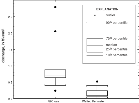 |
| Figure 8. Distribution of streamflow requirements determined by R2Cross and Wetted-Perimeter methods. |
Table 5 shows the average of the cross-section flow requirements within each of the five riffle reaches. The median and mean R2Cross streamflow requirements for habitat protection were 0.75 ft3/s/mi2 and 1.05 ft3/s/mi2, respectively. The median and mean Wetted-Perimeter streamflow requirements were 0.13 ft3/s/mi2 and 0.14 ft3/s/mi2, respectively.
|
|
||||
|
Table 5. Summary of R2Cross and Wetted-Perimeter method streamflow requirements for five riffles sites, Assabet and Charles Rivers, Massachusetts [ft, foot; mi, mile; s, second] |
||||
|
|
||||
| Discharge | ||||
|---|---|---|---|---|
| River and reach | R2Cross (ft3/s/mi2) | Wetted perimeter (ft3/s/mi2) |
||
|
|
||||
| Danforth Brook at Hudson | 2 | .42 | 0 | .05 |
| Elizabeth Brook near Stow | .58 | .17 | ||
| Mine Brook near Franklin | .63 | .32 | ||
| Charles River at Medway downstream | .88 | .13 | ||
| Charles River at Medway upstream | .75 | .04 | ||
| Average | 1 | .05 | .14 | |
| Median | .75 | .13 | ||
A comparison of these median streamflow requirements with observed daily discharges that can be expected during the low-flow summer period at the streamgaging station at Nashoba Brook near Acton (01097300), based on 38 years of record from water year 1963 to water year 2001, is shown in figure 9. The Nashoba Brook is a largely unaltered tributary to the Assabet River; there is only occasional regulation on a small pond in the upper part of the subbasin. The median Wetted-Perimeter streamflow requirement is between the 25th- and 50th-percentile historic daily flows for most of July, August, and September. The median R2Cross streamflow requirement exceeds the 75th percentile for most of the same period. Although comparison of a seasonal streamflow requirement to observed daily discharges at a specific location is interesting, the daily variations in discharges can be influenced by local events and activities that are not indicative of regional conditions.
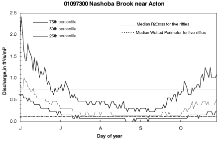 |
| Figure 9. Daily discharge for the streamgaging station at Nashoba Brook near Acton (01097300) for the period 1963 to 2001 compared to median streamflow requirements estimated by the R2Cross and Wetted Perimeter methods, Assabet and Charles Rivers, Massachusetts. |
A diagnostic method and two standard-setting methods (Instream Flow Council, 2002) were applied to streamflow records from 1969 to 1998 for the summer low-flow period from five gaging stations with relatively unaltered flow located in or around the Assabet River and Charles River Basins. The diagnostic method is the Range of Variability Approach (RVA) (Richter and others, 1997). The standard setting methods are the Tennant method (Tennant, 1976) and the New England Aquatic Base-Flow (ABF) method (U.S. Fish and Wildlife Service, 1981; Lang, 1999). The five stations chosen for this analysis were the Squannacook River near West Groton, MA (01096000), Nashoba Brook near Acton, MA (01097300), Old Swamp River near South Weymouth, MA (01105600), Branch River at Forestdale, RI (01111500), and Sevenmile River near Spencer, MA (01175670) (fig. 1).
The RVA method defines target streamflows as measured by the interquartile range for each of 33 statistical indicators of hydrologic alteration (IHA) parameters (Richter and others, 1996). Half of these statistics measure the central tendency of the magnitude or rate of change of flow conditions, and half focus on the magnitude, duration, timing, and frequency of extreme events. An example of the results from an IHA analysis is shown in table 6 for the gage at Nashoba Brook near Acton (01097300) for the period of 1969-98. The results of the IHA analyses for all five gages can be viewed at the US Geological Survey Office in Northborough, Massachusetts.
|
|
||||||||||||||||||||
|
|
||||||||||||||||||||
| Percentile | ||||||||||||||||||||
|---|---|---|---|---|---|---|---|---|---|---|---|---|---|---|---|---|---|---|---|---|
| Period of condition |
|
|||||||||||||||||||
| 10th | 25th | 50th | 75th | 90th | ||||||||||||||||
|
|
||||||||||||||||||||
| Magnitude of month mean discharge, ft3/s(ft3/s/mi2) | ||||||||||||||||||||
|
|
||||||||||||||||||||
| October | 0 | .81 | (0 | .06) | 2 | .14 | (0 | .17) | 5 | .12 | (0 | .40) | 13 | .0 | (1 | .01) | 24 | .8 | (1 | .94) |
| November | 3 | .42 | ( | .27) | 7 | .36 | ( | .58) | 15 | .3 | (1 | .20) | 25 | .6 | (2 | .00) | 35 | .8 | (2 | .80) |
| December | 6 | .30 | ( | .49) | 10 | .1 | ( | .79) | 16 | .5 | (1 | .29) | 35 | .4 | (2 | .77) | 42 | .9 | (3 | .35) |
| January | 4 | .61 | ( | .36) | 10 | .5 | ( | .82) | 21 | .0 | (1 | .64) | 35 | .0 | (2 | .73) | 55 | .7 | (4 | .35) |
| February | 12 | .7 | ( | .99) | 16 | .4 | (1 | .28) | 22 | .4 | (1 | .75) | 38 | .2 | (2 | .98) | 53 | .9 | (4 | .21) |
| March | 20 | .8 | (1 | .63) | 32 | .2 | (2 | .52) | 43 | .4 | (3 | .39 | 52 | .0 | (4 | .06) | 76 | .7 | (5 | .99) |
| April | 16 | .2 | (1 | .26) | 22 | .8 | (1 | .78) | 41 | .2 | (3 | .21) | 54 | .6 | (4 | .26) | 64 | .1 | (5 | .01) |
| May | 10 | .5 | ( | .82) | 15 | .1 | (1 | .18) | 23 | .2 | (1 | .81) | 33 | .1 | (2 | .59) | 39 | .4 | (3 | .08) |
| June | 3 | .82 | ( | .30) | 5 | .60 | ( | .44) | 9 | .12 | ( | .71) | 17 | .8 | (1 | .39) | 42 | .9 | (3 | .35) |
| July | 1 | .11 | ( | .09) | 1 | .72 | ( | .13) | 4 | .13 | ( | .32) | 8 | .71 | ( | .68) | 14 | .6 | (1 | .14) |
| August | .34 | ( | .03) | 1 | .31 | ( | .10) | 2 | .94 | ( | .23) | 6 | .63 | ( | .52) | 9 | .99 | ( | .78) | |
| September | .49 | ( | .04) | 1 | .05 | ( | .08) | 2 | .56 | ( | .20) | 6 | .75 | ( | .53) | 10 | .3 | ( | .81) | |
|
|
||||||||||||||||||||
| Magnitude and duration of annual discharge condition, ft 3/s (ft3/s/mi2) | ||||||||||||||||||||
|
|
||||||||||||||||||||
| 1-day minimum | .08 | ( | .01) | .13 | ( | .01) | .36 | ( | .03) | .97 | ( | .08) | 1 | .43 | ( | .11) | ||||
| 3-day minimum | .09 | ( | .01) | .16 | ( | .01) | .41 | ( | .03) | 1 | .13 | ( | .09) | 1 | .45 | ( | .11) | |||
| 7-day minimum | .11 | ( | .01) | .24 | ( | .02) | .61 | ( | .05) | 1 | .41 | ( | .11) | 1 | .84 | ( | .14) | |||
| 30-day minimum | .20 | ( | .02) | .54 | ( | .04) | 1 | .33 | ( | .10) | 2 | .14 | ( | .17) | 3 | .97 | ( | .31) | ||
| 90-day minimum | .53 | ( | .04) | 1 | .44 | ( | .11) | 3 | .15 | ( | .25) | 4 | .44 | ( | .35) | 6 | .47 | ( | .51) | |
| 1-day maximum | 76 | .1 | (5 | .95) | 103 | (8 | .05) | 174 | (13 | .6) | 260 | (20 | .3) | 366 | (28 | .6) | ||||
| 3-day maximum | 58 | .5 | (4 | .57) | 84 | .8 | (6 | .63) | 144 | (11 | .3) | 227 | (17 | .7) | 311 | (24 | .3) | |||
| 7-day maximum | 44 | .4 | (3 | .47) | 74 | .6 | (5 | .83) | 110 | (8 | .60) | 153 | (11 | .9) | 207 | (16 | .2) | |||
| 30-day maximum | 29 | .8 | (2 | .33) | 43 | .5 | (3 | .40) | 63 | .4 | (4 | .95) | 84 | .3 | (6 | .59) | 98 | .5 | (7 | .70) |
| 90-day maximum | 23 | .8 | (1 | .86) | 31 | .8 | (2 | .49) | 44 | .2 | (3 | .45) | 52 | .5 | (4 | .10) | 64 | .2 | (5 | .02) |
|
7-day minimum/ mean annual discharge |
.01 | ( | .00) | .01 | ( | .00) | .03 | ( | .00) | .09 | ( | .01) | .11 | ( | .01) | |||||
|
|
||||||||||||||||||||
| Timing of annual discharge extremes, Julian day | ||||||||||||||||||||
|
|
||||||||||||||||||||
| Date of minimum 1-day discharge | 210 | .7 | 225 | .25 | 249 | .5 | 262 | .75 | 278 | .1 | ||||||||||
| Date of maximum 1-day discharge | 26 | .7 | 57 | .25 | 78 | .5 | 97 | .5 | 186 | .8 | ||||||||||
|
|
||||||||||||||||||||
| Frequency and duration of high and low pulses, number of days | ||||||||||||||||||||
|
|
||||||||||||||||||||
| Days that daily discharge is less than the 25th percentile | 4 | .26 | 6 | .79 | 8 | .94 | 18 | .86 | 26 | .45 | ||||||||||
| Days that daily discharge is greater than the 75th percentile | 3 | .75 | 4 | .9 | 8 | .63 | 10 | .67 | 14 | .27 | ||||||||||
|
|
||||||||||||||||||||
| Rate and frequency of hydrograph changes, number of days | ||||||||||||||||||||
|
|
||||||||||||||||||||
| Mean of all positive differences between consecutive daily discharges (ft3/s) | 3 | .24 | 5 | .26 | 8 | .34 | 10 | .81 | 12 | .3 | ||||||||||
| Mean of all negative differences between consecutive daily discharges (ft3/s) | -5 | .73 | -4 | .9 | -4 | .14 | -2 | .61 | -1 | .69 | ||||||||||
| Zero-discharge days (count) | 0 | 0 | 0 | 0 | 0 | |||||||||||||||
| Times that daily discharge is less than the 25th percentile daily discharge (count) | 2 | .7 | 4 | 7 | 8 | 11 | ||||||||||||||
| Times that daily discharge is greater than the 75th percentile daily discharge (count) | 5 | .4 | 8 | 10 | 13 | .75 | 18 | .3 | ||||||||||||
| Times that the trends of the differences between consecutive daily discharges reverse (count) | 75 | .7 | 83 | .5 | 90 | .5 | 97 | .75 | 103 | .3 | ||||||||||
|
|
||||||||||||||||||||
The interquartile ranges of the normalized mean-monthly discharges for the five gages for a common period of record (fig. 10), normalized for drainage area, are mostly bracketed by the R2Cross and Wetted Perimeter median streamflow requirements in the summer low-flow period of July through September. The Wetted Perimeter median requirement is close to the 10th-percentile monthly flow for all five months shown; this relation indicates that the Wetted Perimeter streamflow requirement is violated about 10 percent of the time over the summer months.
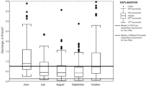 |
| Figure 10. Distribution of mean monthly discharges
for the period 1969-1998 for streamgaging stations 01096000, 01097300,
01105600, 01111500, and 01175670 compared with median streamflow requirements
estimated by the R2Cross and Wetted- Perimeter methods for five riffles in the Assabet and Charles River Basins, Massachusetts. |
In the Tennant method (Tennant, 1976), streamflow requirements are based on the observation that aquatic habitat conditions are similar in streams carrying the same proportion of the mean annual flow (QMA). The Tennant method applies different criteria for winter (October-March) and summer (April-September) flow periods. During summer low-flow periods, minimum streamflows are defined as 40, 30, and 10 percent of the mean annual discharge (QMA); these streamflows create good, fair, and poor habitat conditions, respectively, according to Tennant (1976). The median results for the five gages (01096000, 01097300, 01105600, 01111500, and 01175670) are presented in table 7. The median R2Cross streamflow requirement for the 5 riffles (0.75 ft3/s/mi2; table 9) compares closely to the Tennant 0.4 QMA good-habitat condition requirement (0.71 ft3/s/mi2). The median Wetted-Perimeter streamflow requirement (0.13 ft3/s/mi2; table 9) compares closely to the Tennant 0.1 QMA poor-habitat condition requirement (0.18 ft3/s/mi2). These results also bracket the RVA monthly interquartile ranges for the summer low-flow period.
| Table 7. Median
streamflow requirements estimated by the Tennant technique from the
combined records of streamgaging stations 01096000, 01097300, 01105600,
01111500, and 01175670 [ft3/s/mi2, cubic foot per second per square mile] |
||
|
|
||
| Standard setting technique | Median streamflow requirement from 5 gages (ft3/s/mi2) | |
|---|---|---|
|
|
||
| Tennant—good habitat: | ||
| (0.4 of the average annual discharge) | 0 | .71 |
| Tennant—fair habitat: | ||
| (0.3 of the average annual discharge) | .53 | |
| Tennant—poor habitat: | ||
| (0.1 of the average annual discharge) | .18 | |
|
|
||
Next: Summary and conclusion
Back: Preliminary streamflow requirements for habitat protection
