During the summer, when water levels are naturally low and the demand for water is high, water users are in competition for a limited supply of water. Federal, State, local agencies, and private citizens' groups are concerned that streamflows altered by water withdrawals and returns could reduce the quality and quantity of the habitat that supports the biological integrity of the Assabet River and Charles River systems.
It is generally recognized that the quantity and quality of water may not be sufficient to meet all needs and interests, and that any solutions to competing water needs and interests will require cooperation among many stakeholders. The Massachusetts Department of Environmental Management (MADEM) determined that the Assabet River and Charles River Basins could serve as pilot areas in which to test methods for determining streamflow requirements for habitat protection. The proposal development and funding requests were presented through work plans of the Concord River Watershed and Charles River Watershed Teams for the Massachusetts Executive Office of Environmental Affairs (EOEA) Watershed Initiative program. The U.S. Geological Survey (USGS), in cooperation with the EOEA Watershed Initiative program and MADEM, began a habitat assessment in 2001 to determine the streamflow requirements in the Assabet and Charles River Basins. An additional goal of the USGS is to coordinate the habitat project with a ground-water modeling project for the Assabet River Basin also being conducted in cooperation with MADEM. The results of the modeling project will help to quantify effects of water-use practices on streamflow and habitat.
This report provides preliminary estimates of streamflow necessary to maintain aquatic habitat in the Assabet and Charles Rivers. The study area includes a reach of the mainstem Charles River and reaches on tributaries to the Assabet and Charles Rivers in Massachusetts. The report describes streamflow requirements determined by means of the R2Cross and Wetted-Perimeter methods. Water-surface-profile models were developed and calibrated from channel surveys and discharge measurements made in the summer and fall of 2001. Hydraulic models were calibrated at six sites--two sites on the mainstem Charles River, and one site each on Mine Brook in the Charles River Basin and Elizabeth Brook, Danforth Brook, and Great Brook in the Assabet River Basin. Streamflow requirements for habitat protection were determined at five riffle sites--two riffle sites on the mainstem Charles River, and one site each on Mine Brook in the Charles River Basin and Elizabeth Brook, and Danforth Brook in the Assabet River Basin.
The Assabet River and Charles River are in adjacent drainage basins in Eastern Massachusetts (fig. 1). The Assabet River study sites are in Middlesex County and Worcester County. The Charles River study sites are in Norfolk County. The Assabet River is a subbasin of the Concord River and is bounded by the Nashua River and Blackstone River Basins to the west, the Sudbury River Basin to the East, and Charles River Basin to the south. The Charles River drains into Boston Harbor and is bounded by the Blackstone River Basin to the west, the Sudbury River and Assabet River Basins to the north, and Taunton River and Neponset River Basins to the south.
|
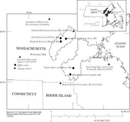
| Figure 1. Location of habitat-assessment riffle reaches in and five streamgaging stations near the Assabet River and Charles River Basins, Massachusetts. |
The three Assabet River study sites are located on riffles on Elizabeth Brook, Great Brook, and Danforth Brook (table 1). The Elizabeth Brook study site is just downstream of a ford on an unnamed road in Stow, MA, and about 0.72 mi upstream of the brook's mouth into the Assabet River. The Great Brook study site is located 1.3 mi east of I-495 near Bolton, MA, and about 1.85 mi upstream of the brook's mouth into Dudley Pond, which is in the Elizabeth Brook Subbasin. The Danforth Brook study site is in Hudson, MA, about 1.35 mi upstream of the brook's mouth into the Assabet River.
| Table 1. Location and characteristics of riffle reaches, Assabet and Charles River, Massachusetts | |||||
| [ft, foot; mi2, square mile] | |||||
| River basin | Stream name | Town | Riffle location | Approximate riffle length (ft) |
Drainage area (mi2) |
|---|---|---|---|---|---|
| Assabet River | Danforth Brook | Hudson | 300 ft upstream of Route 85 culvert | 80 | 5.12 |
| Great Brook | Bolton | Just downstream of Route 117 culvert | 80 | 4.47 | |
| Elizabeth Brook | Stow | 0.2 mi south of White Pond Road | 70 | 18.7 | |
| Charles River | Mine Brook | Franklin | 680 ft upstream of Route 140 culvert | 87 | 10.0 |
| Charles River | Medway | 1480 ft upstream of Walker Street Bridge | 30 | 65.7 | |
| Charles River | Medway | 600 ft upstream of Walker Street Bridge | 110 | 65.7 | |
The two Charles River study sites are at two riffles on the mainstem upstream of the Walker Street Bridge and the gage at Charles River at Medway (01103200). The Mine Brook study site is at a riffle about 800 ft east of the intersection of Routes 140 and I-495 in Franklin, MA (table 1).
The authors are grateful to Sue Beede and Sue Flint from the Organization of the Assabet River, and to Anna Eleria and Dudley Bonsal from the Charles River Watershed Association, who provided assistance with field surveys and surface-water data collection during this study. The cooperation of public and private landowners, who granted access to the Assabet and Charles River riffle study sites, is also appreciated.
Next: Methods for determining streamflow requirements for habitat protection
Previous: Abstract
Table of Contents
| AccessibilityFOIAPrivacyPolicies and Notices | |
 |
|