Link to USGS home page

Polygon coverage SCAMPA, boundaries of proposed marine reserves in the area of the northern Channel Islands

Metadata also available as [parseable text]

Frequently-anticipated questions:


What does this data set describe?

    Title:
    Polygon coverage SCAMPA, boundaries of proposed marine reserves in the area of the northern Channel Islands
    Abstract:
    Polygon coverage SCAMPA, boundaries of proposed marine reserves in the area of the northern Channel Islands by Ben Waltenberger.

    Supplemental_Information:

    Any use of trade, product, or firm names is for descriptive purposes only and does not imply endorsement by the U.S. Government.

    Although this Federal Geographic Data Committee-compliant metadata file is intended to document the data set in nonproprietary form, as well as in ArcInfo format, this metadata file may include some ArcInfo-specific terminology.

  1. How should this data set be cited?

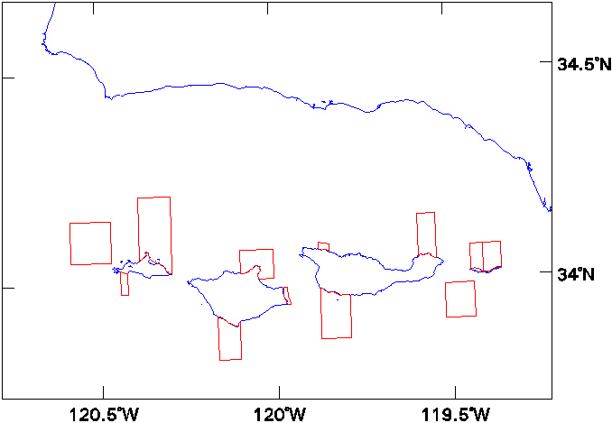
    Waltenberger, Ben, 2001, Polygon coverage SCAMPA, boundaries of proposed marine reserves in the area of the northern Channel Islands:.

    This is part of the following larger work.

    Cochrane, Guy R. , Nasby, Nicole, Reid, Jane A. , Waltenberger, Ben, and Lee, Kristen, 2003, Nearshore Benthic Habitat GIS for the Channel Islands National Marine Sanctuary and Southern California State Fisheries Reserves, Volume 1: USGS Open-File Report USGS OFR 03-85, U.S. Geological Survey, Menlo Park, CA.

    Online Links:

  2. What geographic area does the data set cover?

    West_Bounding_Coordinate: -120.58357239
    East_Bounding_Coordinate: -118.90743256
    North_Bounding_Coordinate: 34.20654297
    South_Bounding_Coordinate: 33.36573029

  3. What does it look like?

    <http://geopubs.wr.usgs.gov/open-file/of03-85/basemaps/scampa.jpg> (JPEG)
    JPEG file of boundary lines

  4. Does the data set describe conditions during a particular time period?

    Calendar_Date: 2001
    Currentness_Reference: Ground Condition

  5. What is the general form of this data set?

    Geospatial_Data_Presentation_Form: map

  6. How does the data set represent geographic features?

    1. How are geographic features stored in the data set?

      This is a Vector data set. It contains the following vector data types (SDTS terminology):

      • String (14)
      • GT-polygon composed of chains (14)

    2. What coordinate system is used to represent geographic features?

      Horizontal positions are specified in geographic coordinates, that is, latitude and longitude. Latitudes are given to the nearest 0.002000000095. Longitudes are given to the nearest 0.002000000095. Latitude and longitude values are specified in Decimal Degrees.

      The horizontal datum used is North American Datum of 1983.
      The ellipsoid used is GRS1980.
      The semi-major axis of the ellipsoid used is 6378206.4.
      The flattening of the ellipsoid used is 1/294.98.

  7. How does the data set describe geographic features?

    Entity_and_Attribute_Overview:


    SCAMPA.PAT:


    COLUMN   ITEM NAME        WIDTH OUTPUT  TYPE N.DEC  ALTERNATE NAME
    
        1  AREA                   4    12     F      3
    
        5  PERIMETER              4    12     F      3
    
        9  SCAMPA#                4     5     B      -
    
       13  SCAMPA-ID              4     5     B      -


    SCAMPA.AAT:


    COLUMN   ITEM NAME        WIDTH OUTPUT  TYPE N.DEC  ALTERNATE NAME
    
        1  FNODE#                 4     5     B      -
    
        5  TNODE#                 4     5     B      -
    
        9  LPOLY#                 4     5     B      -
    
       13  RPOLY#                 4     5     B      -
    
       17  LENGTH                 4    12     F      3
    
       21  SCAMPA#                4     5     B      -
    
       25  SCAMPA-ID              4     5     B      -
    
       29  ID                     8     8     F      0
    
       37  NAME                  16    16     C      -
    
       53  CLASS                 20    20     C      -
    
       73  COMMERCIAL            20    20     C      -
    
       93  RECREATION            20    20     C      -


    Entity_and_Attribute_Detail_Citation: none


Who produced the data set?

  1. Who are the originators of the data set? (may include formal authors, digital compilers, and editors)

  2. Who also contributed to the data set?

  3. To whom should users address questions about the data?

    Satie Airame
    CINMS,Channel Islands National Marine Sanctuary
    Scientific Advisor
    CINMS, 113 Harbor Way, Suite 150
    Santa Barbara, CA 93109
    USA

    (805) 884-1468 (voice)
    (805) 568-1582 (FAX)
    Satie.Airame@noaa.gov


Why was the data set created?

These data are intended for science researchers, students, policy makers, and the general public. The data can be used with geographic information systems (GIS) software to display geologic and oceanographic information.


How was the data set created?

  1. From what previous works were the data drawn?

    unknown (source 1 of 1)
    unknown, unknown, unknown: unknown unknown, unknown, unknown.

    Type_of_Source_Media: unknown
    Source_Contribution: unknown

  2. How were the data generated, processed, and modified?

    Date: unknown (process 1 of 2)
    unknown

    Date: 05-Aug-2002 (process 2 of 2)
    First draft of metadata created by Guy R. Cochrane using FGDCMETA.AML ver. 1.35 08/02/2000 on ArcInfo data set /we5/guy/chanil/basemaps/scampa

  3. What similar or related data should the user be aware of?


How reliable are the data; what problems remain in the data set?

  1. How well have the observations been checked?

    unknown

  2. How accurate are the geographic locations?

    unknown

  3. How accurate are the heights or depths?

  4. Where are the gaps in the data? What is missing?

    unknown

  5. How consistent are the relationships among the observations, including topology?

    Polygon and chain-node topology present.


How can someone get a copy of the data set?

Are there legal restrictions on access or use of the data?

Access_Constraints: None
Use_Constraints: None

  1. Who distributes the data set? (Distributor 1 of 1)

    United States Geological Survey (USGS)
    c/o Guy R. Cochrane
    Geophysicist
    USGS, MailStop 999, 345 Middlefield Road
    Menlo Park, CA 94025-3561
    USA

    (650) 329-5076 (voice)
    (650) 329-5190 (FAX)
    gcochrane@usgs.gov

  2. What's the catalog number I need to order this data set?

  3. What legal disclaimers am I supposed to read?

    Please recognize the U.S. Geological Survey (USGS) as the source of this information.

    Although these data have been used by the U.S. Geological Survey, U.S. Department of the Interior, no warranty expressed or implied is made by the U.S. Geological Survey as to the accuracy of the data.

    The act of distribution shall not constitute any such warranty, and no responsibility is assumed by the U.S. Geological Survey in the use of this data, software, or related materials.

  4. How can I download or order the data?


Who wrote the metadata?

Dates:
Last modified: 05-Aug-2002
Last Reviewed: 05-Aug-2003

Metadata author:
United States Geological Survey (USGS)
c/o Guy R. Cochrane
Geophysicist
USGS, MailStop 999, 345 Middlefield Road
Menlo Park, CA 94025-3561
USA

(650) 329-5076 (voice)
(650) 329-5190 (FAX)
gcochrane@usgs.gov

Metadata standard:
FGDC Content Standards for Digital Geospatial Metadata ("CSDGM version 2") (FGDC-STD-001-1998)


Generated by mp version 2.7.9 on Fri Jan 10 16:19:38 2003
http://geopubs.wr.usgs.gov/open-file/of03-85/basemaps/scampaf.html
maintained by Carolyn Donlin
last modified 11 March 2003 (grc)
USGS Privacy Statement   |   Disclaimer   |   Feedback   |   Accessibility
Department of the Interior   U.S. Geological Survey   Geologic Division   Western Region Coastal & Marine Geology