
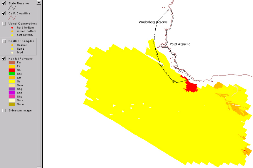
Benthic habitat polygon coverages have been created for marine reserve locations surrounding the Santa Barbara Basin. Diver, ROV and submersible video transects, bathymetry data, sedimentary samples, and sonar mapping, have been integrated to describe the geological, biological, and oceanographic aspects of habitat. Big Sycamore reserve, is part of the Marine Ecological Reserves Research Program (MERRP). The U.S. Geological Survey (USGS), in a cooperative project with Sea Grant-MERRP and investigators at National Marine Fisheries Service (NMFS), the Channel Islands National Marine Sanctuary (CINMS), and National Park Service (NPS) has collected sidescan sonar and video data to produce a polygon coverage. The habitat polygons have attributes for megahabitat, bottom induration, macrohabitat (where macrohabitat observations are available), polygon area, polygon perimeter, and water depth. The habitat GIS shows rocky habitat suitable for rockfish (Sebastes sp.), abalone (Haliotis sp.), and other threatened benthic species from the shoreline out to the 100-m depth limit of the survey.
Additional information about the field activities from which this data set was derived are available online at
Any use of trade, product, or firm names is for descriptive purposes only and does not imply endorsement by the U.S. Government.
Although this Federal Geographic Data Committee-compliant metadata file is intended to document the data set in nonproprietary form, as well as in ArcInfo format, this metadata file may include some ArcInfo-specific terminology.
Cochrane, Guy R. , 2001, Coverage svanhab -- Habitat polygons for Point Arguelo study area: USGS Open-File Report USGS OFR 03-85, U.S. Geological Survey, Menlo Park.This is part of the following larger work.Online Links:
Cochrane, Guy R. , Nasby, Nicole M. , Reid, Jane A. , Waltenberger, Ben, and Lee, Kristen M. , 2003, Nearshore Benthic Habitat GIS for the Channel Islands National Mairne Santuary and Southern California State Fisheries Reserves, Volume 1.
This is a Vector data set. It contains the following vector data types (SDTS terminology):
Horizontal positions are specified in geographic coordinates, that is, latitude and longitude. Latitudes are given to the nearest 0.000007670943. Longitudes are given to the nearest 0.000007670943. Latitude and longitude values are specified in Decimal Degrees.
The horizontal datum used is North American Datum of 1983.
The ellipsoid used is GRS1980.
The semi-major axis of the ellipsoid used is 6378206.4.
The flattening of the ellipsoid used is 1/294.98.
SVANHAB.PAT:


COLUMN   ITEM NAME        WIDTH OUTPUT  TYPE N.DEC  ALTERNATE NAME

    1  AREA                   4    12     F      3

    5  PERIMETER              4    12     F      3

    9  SVANHAB#               4     5     B      -

   13  SVANHAB-ID             4     5     B      -

   17  MEGA_ID                1     1     C      -

   18  BOTTOM_ID              1     1     C      -

   19  GEO_UNIT               8     8     C      -

   27  MSO_MRC_ID             8     8     C      -

   35  MDFR_ID                8     8     C      -

   43  CODE                   8     8     C      -
Attributes 6-8 are benthic habitat classification attributes: megahabitat,
bottom induration, meso-macrohabitat, and modifiers from Green and others,
1999.
CODE is a combination of the habitat attributes.
MEGA_ID is usually S for Shelf, but may be F for basin or canyon flank.
BOTTOM_ID is h for hard bottom, m for mixed hard and soft bottom, or
s for soft sediment bottom
MSO_MRC_ID is based on visual observations of kelp (k), sand waves (w)
and other macrohabitats described in Greene and others 1999.
MDFR_ID are modifiers to describe the texture or lithology of the seafloor
such as f for fractured.
Thanks to the Staff of the Channel Islands National Marine Sanctuary, the crew of the NOAA R/V Ballena, the crew of the NOAA R/V MacArthur, and the crew of the UCSD R/V Sproul.
Guy R. Cochrane
United States Geological Survey (USGS)
Geologist, GIS Coordinator
USGS, MailStop 999, 345 Middlefield Road
Menlo Park, CA 94025-3561
USA
(650) 329-5076 (voice)
(650) 329-5190 (FAX)
gcochrane@usgs.gov
These data are intended for science researchers, students, policy makers, and the general public. The data can be used with geographic information systems (GIS) software to display geologic and oceanographic information.
Habitat polygons were hand drawn from a georefereced sidescan sonar mosaic tiff.
Habitat attribute types are from Greene, G.H., Yoklavich, M.M., Starr, R.M., O'Connell, V.M., Wakefield, W.W., Sullivan, D.E., McRea, J.E., and Cailliet, G.M., 1999. A classification scheme for deep seafloor habitats. Oceanologica Acta, 22, 663-678.
Macrohabitat attributes assignments are limited to areas where bottom video has been collected.
Accuracy of the horizontal coordinates is on the order of 10 m based on uncertainty in position of sidescansonar fish relative to ships gps position.
Macrohabitat classification is missing where video information is lacking.
Polygon topology present. Every polygon has a label and are all polygons closed.
Are there legal restrictions on access or use of the data?
- Access_Constraints: None
- Use_Constraints: Not suitable for navigation
United States Geological Survey (USGS)
c/o Guy R. Cochrane
Geologist, GIS Coordinator
USGS, MailStop 999, 345 Middlefield Road
Menlo Park, CA 94025-3561
USA
(650) 329-5076 (voice)
(650) 329-5190 (FAX)
gcochrane@usgs.gov
Please recognize the U.S. Geological Survey (USGS) as the source of this information.Although these data have been used by the U.S. Geological Survey, U.S. Department of the Interior, no warranty expressed or implied is made by the U.S. Geological Survey as to the accuracy of the data.
The act of distribution shall not constitute any such warranty, and no responsibility is assumed by the U.S. Geological Survey in the use of this data, software, or related materials.
United States Geological Survey (USGS)
c/o Guy R. Cochrane
Geologist, GIS Coordinator
USGS, MailStop 999, 345 Middlefield Road
Menlo Park, CA 94025-3561
USA
(650) 329-5076 (voice)
(650) 329-5190 (FAX)
gcochrane@usgs.gov