 Introduction Introduction
Open-File Report 03-105 contains a digital geologic map database for the northeast part of the Dillingham 1:250,000-scale quadrangle, specifically the D-1, D-2, C-1, and C-2 1:63,360-scale map sheets. The report includes:
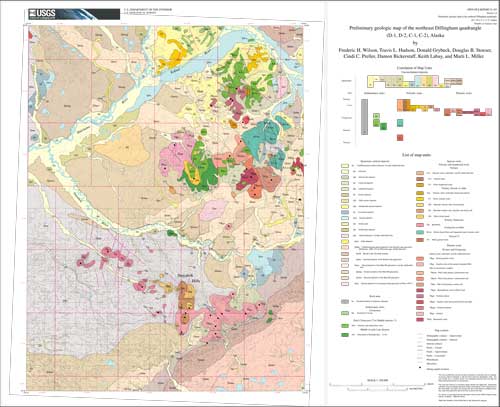
- A Postscript file showing the geologic map on a topographic and land-grid base, and containing a Correlation of Map Units diagram (CMU), and a List of Map Units. (Note the size of the map when printed at publication scale (1:100,000) is 30 by 24 inches (76 by 61 cm).
- A PDF document providing Introductory text, Description of Map Units (DMU), References, and a table of radiometric ages.
- A collection of ARC/INFO (http://www.esri.com, Environmental Systems Research Institute) version 7.2.1 coverages (as export files) of the elements of the geologic map, including:
a. Network coverage containing the geologic polygons, contacts, and faults,
b. Annotation coverage containing the geologic unit labels and leaders,
c. Point coverage containing the radiometric age sample localities,
d. Template files containing the lookup table structure used to produce the map. Data to populate the template files is provided in comma-separated value (.csv) text files as follows:
napkey.csv
plutonkey.csv
geoline.csv
e. Network coverage containing the Correlation of Map Units (CMU) for the map.
- Portable Document Format (.pdf) files consisting of:
a. Introductory text, Description of Map Units (DMU), References, and a table of radiometric ages for the map.
b. A graphic of the map as in the Postscript file above.
- FGDC compliant metadata for the digital data files (coverages).
The Correlation of Map Units and Description of Map Units are in a format similar to that of the USGS Geologic Investigations Series (I-series) maps but have not been edited to comply with I-map standards. Even though this is an Open-File Report and includes the standard USGS Open-File disclaimer, the report closely adheres to the Stratigraphic Nomenclature of the U.S. Geological Survey.
ARC/INFO symbolsets (shade and line) as used for these maps have been made available elsewhere as part of Geologic map of Central (Interior) Alaska, published as a USGS Open-File Report (Wilson and others, 1998, http://geopubs.wr.usgs.gov/open-file/of98-133-a/).
This product does not include the digital topographic base or land-grid files used to produce the map, nor does it include the AML and related ancillary key and other files used to assemble the components of the map.
|
First posted June 5, 2003
File
Name |
Description |
File
Size |
Files
for plotting and viewing |
|
Postscript
file showing the geologic map on a topographic and land-grid base. Scale
1:100,000. Map is 30 x 24 inches |
12.2
MB |
|
Portable
Document Format (PDF) file showing the geologic map on a topographic and
land-grid base. Scale 1:100,000. Map is 30 x 24 inches |
1.1
MB |
|
Explanatory
pamphlet of description of map units for geologic map and introductory text,
as a PDF file |
364
KB |
Metadata
files |
| dinegeol_meta.htm |
HTML
version of the FGDC-compliant metadata for this report |
48
KB |
| dinegeol_meta.txt |
ASCII
text version of the FGDC-compliant metadata for this report |
36
KB |
| dinegeol_meta.faq.html |
Frequently
asked questions about the FGDC-compliant metadata |
32
KB |
ARC/Info
coverages |
| dinegeol.e00 |
ARC
export file for network coverage containing geologic polygons, labels and
contacts (including faults) |
2.8
MB |
| dinegeol_anno.e00 |
ARC
export file for Annotation coverage for geologic map |
396
KB |
| dinecmu.e00 |
ARC
export file for Correlation of map units coverage |
60
KB |
| geoline.e00 |
Look
up table linked to the coverages listed above |
8
KB |
| napkey.e00 |
Look
up table linked to the coverages listed above |
16
KB |
| plutonkey.e00 |
Look
up table linked to the coverages listed above |
4
KB |
Files
for use with ARC View |
| geoline.csv |
File
containing the contents of the geoline look-up table as comma separated
values |
8
KB |
| napkey.csv |
File
containing the contents of the napkey look-up table as comma separated values |
8
KB |
| plutonkey.csv |
File
containing the contents of the plutonkey look-up table as comma separated
values |
4
KB |
The National Geologic Map Database has additional data about this publication
Part or all of this report is presented in Portable Document Format (PDF). For best results viewing and printing PDF documents, it is recommended that you download the documents to your computer and open them with Adobe Reader. PDF documents opened from your browser may not display or print as intended. Download the latest version of Adobe Reader, free of charge.
|

