|
|
GC-2 and BC-2A Analyses
Field Descriptions of GC-2 and
BC-2A
| Core ID |
Length (m) |
Latitude |
Longitude |
Setting |
Description |
| BC2A |
0.42 |
38� 03' 49.076 |
122� 21' 26.239 |
Middle Shoal |
Water depth 2.8m |
| GC2 |
3.1 |
38� 03' 48.571 |
122� 21' 25.725 |
Middle Shoal |
Complete penetration; green-gray mud on outside of barrel; CC sample plus 2
samples from top; Bottom section: contains lot of water, dark + lighter gray
in color; minor black spots in upper part, partly coarser grained + black
material in middle of section; remarkably cohesive mud; Top section: dark +
lighter gray mud; air pocket in upper part of section. |
X-radiographs (0-310 cm)
Click on the above link to view X-ray
scans for BC-2A and GC-2.
Magnetic Susceptibility and X-ray Descriptions
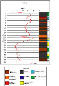
Click image for a larger version (68 kb
JPEG)
TOP OF PAGE
|