Open-File Report 03-120
Title: Dahlia Shoals, Lake Michigan, Michigan
Abstract:
XYZ ASCII format generated from 2001 Lidar survey. These data were collected by the SHOALS (Scanning Hydrographic Operational Airborne Lidar Survey) system which consists of an airborne laser transmitter/receiver capable of measuring 400 soundings per second.
Supplemental_Information:
The system operates from a deHavilland DHC-6 Twin Otter flying at altitudes between 200 and 400 meters with a ground speed of about 100 knots. The SHOALS system also includes a ground-based data processing system for calculating acurate horizontal position and water depth. Lidar is an acronym for LIght Detection And Ranging. The system operates by emitting a pulse of light that travels from an airborne platform to the water surface where a small portion of the laser energy is backscattered to the airborne receiver. The remaining energy at the water's surface propogates through the water column and reflects off the sea bottom and back to the airborne detector. The time difference between the surface return and the bottom return corresponds to water depth. The maximum depth the system is able to sense is related to the complex interaction of radiance of bottom material, incident sun angle and intensity, and the type and quantity of organics or sediments in the water column. As a rule-of-thumb, the SHOALS system should be capable of sensing bottom to depths equal to two or three times the Secchi depth.
How should this data set be cited?
US Army Engineer Joint Airborne Lidar Bathymetry Technical Center of Expertise.(ed.), 20011000, Dahlia Shoals, Lake Michigan, Michigan:.
This is part of the following larger work.
Barnes, Peter, Fleisher, Guy, Gardner, James V. , and Lee, Kristen, 2003, Bathymetry and selected perspective views of 6 reef and coastal areas in Northern Lake Michigan: USGS Open-File Report USGS OFR 03-120, U.S. Geological Survey, Menlo Park, CA.
Online Links:
<http://geopubs.wr.usgs.gov/open-file/of03-120>
What geographic area does the data set cover?
West_Bounding_Coordinate: -085.242000
East_Bounding_Coordinate: -085.158000
North_Bounding_Coordinate: +45.670000
South_Bounding_Coordinate: +45.600000
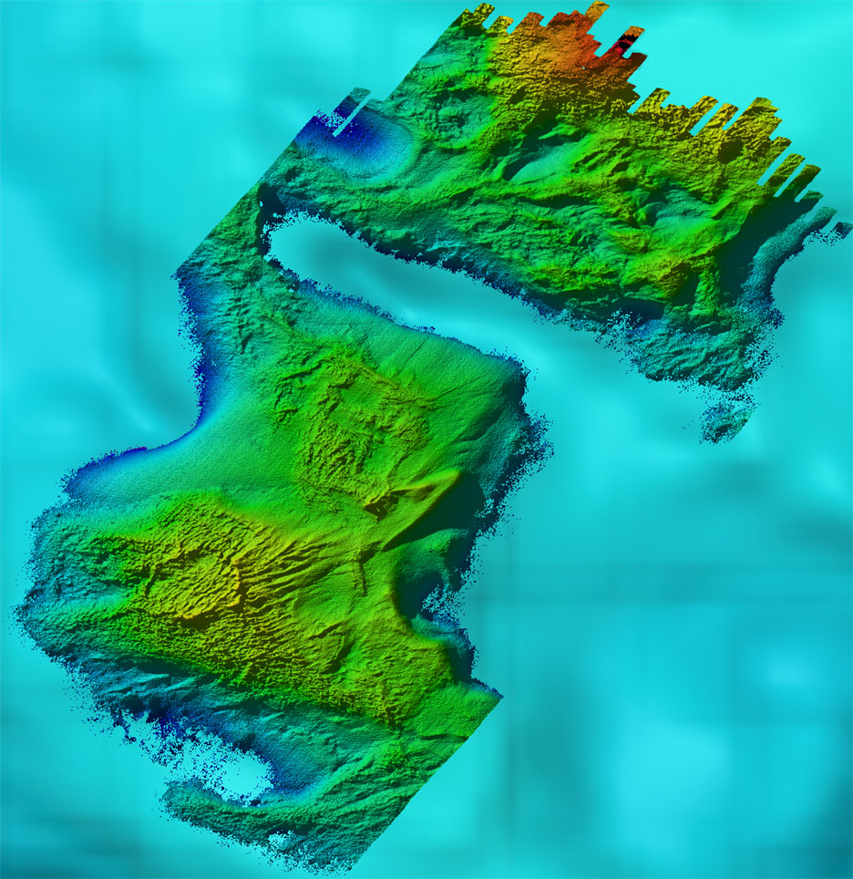
<http://geopubs.wr.usgs.gov/open-file/of03-120/images/map/newdahlia_mapL.jpg> (JPEG)
Shaded relief map view of Dahlia Shoals
Does the data set describe conditions during a particular time period?
Calendar_Date: Aug-2001
Currentness_Reference: Ground Condition
What is the general form of this data set?
Geospatial_Data_Presentation_Form: XYZ ASCII
How does the data set represent geographic features?
How are geographic features stored in the data set?
Indirect_Spatial_Reference: Dahlia Shoals, Lake Michigan, Michigan
This is a Point data set. It contains the following vector data types (SDTS terminology):
Point
What coordinate system is used to represent geographic features?
Horizontal positions are specified in geographic coordinates, that is, latitude and longitude. Latitudes are given to the nearest 0.00004. Longitudes are given to the nearest 0.00004. Latitude and longitude values are specified in Decimal degrees.
The horizontal datum used is WGS84.
The ellipsoid used is WGS84.
The semi-major axis of the ellipsoid used is 6378137.00 meters.
The flattening of the ellipsoid used is 1/0.003352811.
How does the data set describe geographic features?
Entity_and_Attribute_Overview:
Each record consists of three fields: longitude, latitude, and depth in meters. Example of records:
 -85.227030085 45.625738034 152.33000
 -85.226539268 45.626400990 153.21000
 -85.226525081 45.626090234 152.82000
 -85.226510770 45.625144904 152.49000
Entity_and_Attribute_Detail_Citation: none
Who are the originators of the data set? (may include formal authors, digital compilers, and editors)
US Army Engineer Joint Airborne Lidar Bathymetry Technical Center of Expertise.(ed.)
Who also contributed to the data set?
To whom should users address questions about the data?
U.S. Army Corps of Engineers JALBCTX
109 St. Joseph Street
Mobile, Alabama 36602
USA
(334) 694-3721 (voice)
(334) 690-3464 (FAX)
The purpose of the survey was to provide bathymetry and albedo dat for utilization in habitat studies.
From what previous works were the data drawn?
None (source 1 of 1)
U.S. Army Corps of Engineers JALBTCX, 20011000, Dahlia Shoals, Lake Michigan, Michigan.
Type_of_Source_Media: CD-ROM
Source_Contribution: SHOALS
How were the data generated, processed, and modified?
Date: Sep-2001 (process 1 of 1)
The SHOALS airborne system acquires a tremendous volume of raw data during a single mission. The lidar data are unique and require a specialized Data Processing System (DPS) for post-processing. The DPS main funcions 1) import airborne data stored on high density data tape; 2) perform quality control checks on initial depths and horizontal positions; 3) provide display and edit capabilities; 4) calculate depth and position (XYZ) values for each sounding; and 5) output final positions and depths for each sounding.
What similar or related data should the user be aware of?
US Army Engineer Joint Airborne Lidar Bathymetry Technical Center of Expertise.(ed.), 20011000, Boulder Reef, Lake Michigan, Michigan.
Online Links:
<http://walrus.wr.usgs.gov/infobank/t/t101lm/html/t-1-01-lm.meta.html>
How well have the observations been checked?
SHOALS has demonstrated capabilities that meet US Army Corps of Engineers Hydrographic Survey accuracy requirements for Class 1 surveys and the International Hydrographic Organization nautical charting standards for Order 1.
How accurate are the geographic locations?
+/- 3 meters (1 sigma)
How accurate are the heights or depths?
+/- 15 cm (1 sigma)
Where are the gaps in the data? What is missing?
Complete
How consistent are the relationships among the observations, including topology?
None
Are there legal restrictions on access or use of the data?
Access_Constraints: None
Use_Constraints:
Acknowledgement of the U.S. Army Engineer Joint Airborne Lidar Bathymetry Technical Center of Expertise (JALBCTX) would be appreciated in products derived from these data.
Who distributes the data set? (Distributor 1 of 1)
U.S Geological Survey
c/o Peter Barnes
MS999 345 Middlefield Road
Menlo Park, CA 94025
916-329-5265 (voice)
What's the catalog number I need to order this data set?
What legal disclaimers am I supposed to read?
These data not intended for navigational purposes.
Although these data have been used by the U.S. Geological Survey, U.S. Departmempnt of the Interior, these data and information are provided with the understanding that they are not guaranteed to be usable, timely, accurate, or complete. Users are cautioned to consider carefully the provisional nature of these data and information before using them for cisions that concern personal or public safety or the conduct of business that involves substantial monetary or operational consequences. Conclusions drawn from, or actions undertaken on the basis of, such data and information are the sole responsibility of the user.
Neither the U.S. Government nor any agency thereof, nor any of their employees, contractors, or subcontractors, make any warranty, express or implied, nor assume any legal liability or responsibility for the accuracy, completeness, or usefulness of any data, software, information, apparatus, product, or process disclosed, nor represent that its use would not infringe on privately owned rights.
Trade, firm, or product names and other references to non-USGS products and services are provided for information only and do not constitute endorsement or warranty, express or implied, by the USGS, USDOI, or U.S. government, as to their suitability, content, usefulness, functioning, completeness, or accuracy.
How can I download or order the data?
Availability in digital form:
| Data format: | ASCII |
|---|---|
| Network links: | <http://geopubs.wr.usgs.gov/open-file/of03-120> |
Cost to order the data: None
Dates:
Last modified: 30-Jan-2003
Last Reviewed: Feb-2003
Metadata author:
USGS
c/o Kristen Lee
Physical Science Technican
USGS, MailStop 999, 345 Middlefield Road
Menlo Park, CA 94025-3561
USA
(650) 329-5260 (voice)
(650) 329-5411 (FAX)
kmlee@usgs.gov
Metadata standard:
Content Standard for Digital Geospatial Metadata ("CSDGM version 2") (FGDC-STD-001-1998)

![]() U.S. Department of the Interior |
U.S. Geological Survey
U.S. Department of the Interior |
U.S. Geological Survey
URL: http://pubsdata.usgs.gov/pubs/of/2003/0120/metadata/dahliafaq.html
Page Contact Information: GS Pubs Web Contact
Page Last Modified: Thursday, 03-Apr-2014 10:21:22 EDT
