 Abstract Abstract
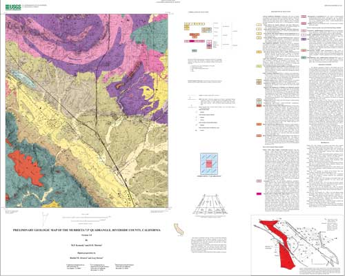
The Murrieta quadrangle is located in the northern part of the Peninsular Ranges Province and includes parts of two structural blocks, or structural subdivisions of the province. The quadrangle is diagonally crossed by the active Elsinore fault zone, a major fault zone of the San Andreas fault system, and separates the Santa Ana Mountains block to the west from the Perris block to the east. Both blocks are relatively stable internally and within the quadrangle are characterized by the presence of widespread erosional surfaces of low relief. The Santa Ana Mountains block, in the Murrieta quadrangle, is underlain by undifferentiated, thick-layered, granular, impure quartzite and well-layered, fissile, phyllitic metamorphic rock of low metamorphic grade. Both quartzite and phyllitic rocks are Mesozoic. Unconformably overlying the metamorphic rocks are remnants of basalt flows having relatively unmodified flow surfaces. The age of the basalt is about 7-8Ma. Large shallow depressions on the surface of the larger basalt remnants form vernal ponds that contain an endemic flora. Beneath the basalt the upper part of the metamorphic rocks is deeply weathered. The weathering appears to be the same as the regional Paleocene saprolitic weathering in southern California. West of the quadrangle a variable thickness sedimentary rock, physically resembling Paleogene rocks, occurs between the basalt and metamorphic rock. Where not protected by the basalt, the weathered rock has been removed by erosion. The dominant feature on the Perris block in the Murrieta quadrangle is the south half of the Paloma Valley ring complex, part of the composite Peninsular Ranges batholith. The complex is elliptical in plan view and consists of an older ring-dike with two subsidiary short-arced dikes that were emplaced into gabbro by magmatic stoping. Small to large stoped blocks of gabbro are common within the ring-dikes. A younger ring-set of hundreds of thin pegmatite dikes occur largely within the central part of the complex. These pegmatite dikes were emplaced into a domal fracture system, apparently produced by cauldron subsidence, and include in the center of the complex, a number of flat-floored granophyre bodies. The granophyre is interpreted to be the result of pressure quenching of pegmatite magma. Along the eastern edge of the quadrangle is the western part of a large septum of medium metamorphic grade Mesozoic schist. A dissected basalt flow caps the Hogbacks northeast of Temecula, and represents remnants of a channel filling flow. Beneath the basalt is a thin deposit of stream gravel. Having an age of about 10Ma, this basalt is about 2-3Ma older than the basalt flows in the Santa Ana Mountains. The Elsinore fault zone forms a complex of pull-apart basins. The west edge of the fault zone, the Willard Fault, is marked by the high, steep eastern face of the Santa Ana Mountains. The east side of the zone, the Wildomar Fault, forms a less pronounced physiographic step. In the center of the quadrangle a major splay of the fault zone, the Murrieta Hot Springs Fault, strikes east. Branching of the fault zone causes the development of a broad alluvial valley between the Willard Fault and the Murrieta Hot Springs Fault. All but the axial part of the zone between the Willard and Wildomar Faults consist of dissected Pleistocene sedimentary units. The axial part of the zone is underlain by Holocene and latest Pleistocene sedimentary units.
|
First posted June 19, 2003
The National Geologic Map Database has additional data about this publication
Part or all of this report is presented in Portable Document Format (PDF). For best results viewing and printing PDF documents, it is recommended that you download the documents to your computer and open them with Adobe Reader. PDF documents opened from your browser may not display or print as intended. Download the latest version of Adobe Reader, free of charge.
|

