Open-File Report 03-383
Figure 1. Upper Yuba River Watershed Studies Program (UYRSP) area. Small rectangle
(in red) around Englebright Lake shows the geographic limits of the maps in this report..
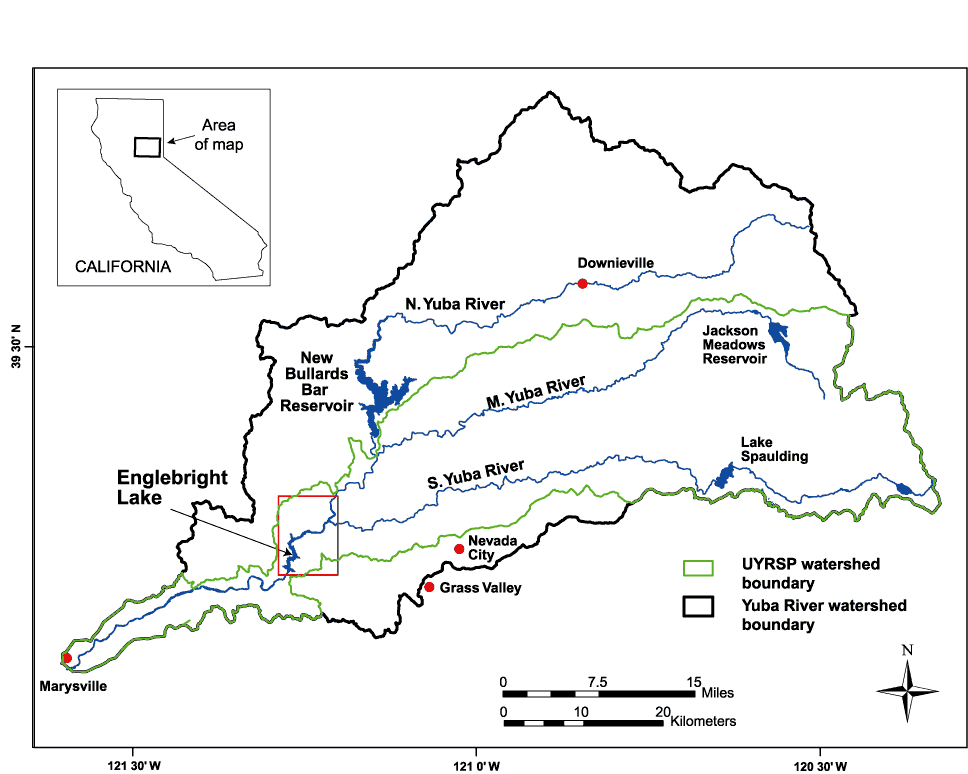
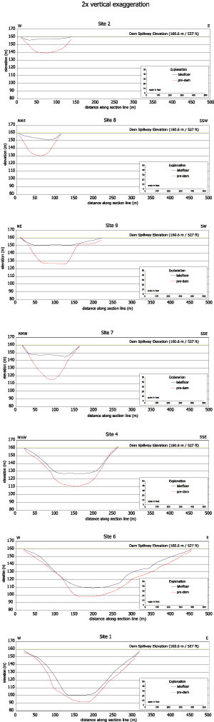
Figure 8. Transverse cross sections of lake floor and pre-dam elevation models at coring locations, from upstream (Site 2) to downstream (Site 1) . The USGS is planning to remap the reservoir bathymetry using a phase-discrimination wide-swath sonar system. This mapping produces both continuous swath bathymetry with a lateral resolution of better than 20 cm (8 in), as well as sidescan backscatter images. Another attempt to image the subbottom by seismic reflection profiling using different acoustic sources is also under consideration. The authors would like to thank: Larry Kooker, Gerald O'Brien, Patrick Hart, Hank Chezar, Tom Reiss, Mike Boyle, and Walt Olson (all of the USGS) for their assistance in conducting the field programs; Brian Haskell (University of Minnesota), the staff of DOSECC Incorporated, and numerous other USGS personnel for their work on the coring project; and Amy Foxgrover, Gerald Hatcher, and Shawn Higgins (all of the USGS) for assistance with ArcGIS. Peter Triezenberg assisted with the preparation of the final web presentation of the report. This report benefitted from reviews by David Rubin and Charles Alpers. Chris Ransome & Associates, 1998, Bathymetric, subbottom and sidescan survey in Marysville, California on Narrows Dam for Bookman-Edmonston Engineering, Final Report, May 18, 1998, CRA Job# 98011, unpublished Snyder, Noah P., Rubin, David M., Alpers, Charles N., Flint, Lorraine E., Curtis, Jennifer A., Childs, Jonathan R., and Haskell, Brian J., 2002, A record of rapid fluvial sedimentation in the Sierra Nevada hydraulic mining region: preliminary results from the 2002 Englebright Lake coring project; Paper No. 78-2, Geological Society of America 2002 Annual Meeting, Denver, CO Snyder, Noah P., Childs, Jonathan R., Hampton, Margaret A., Rubin, David M., Alpers, Charles N., Flint, Lorraine E., Curtis, Jennifer A., Wright, Scott A., and Topping, David J., 2003, The history and future of sediment deposition behind Englebright Dam, Yuba River, Northern California; Paper No. 140-5, Geological Society of America 2003 Annual Meeting, Seattle, WA RELATED LINKS Upper Yuba River Studies Program For questions about the content of this report contact This report is available only on the Web |

![]() U.S. Department of the Interior |
U.S. Geological Survey
U.S. Department of the Interior |
U.S. Geological Survey
URL: http://pubsdata.usgs.gov/pubs/of/2003/0383/figure1.html
Page Contact Information: GS Pubs Web Contact
Page Last Modified: Monday, 07-Apr-2014 14:59:36 EDT