 Introduction
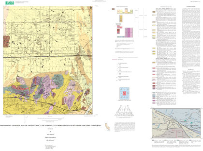
Open-File Report 03-418 is a digital geologic data set that maps and describes the geology of the Fontana 7.5’ quadrangle, Riverside and San Bernardino Counties, California. The Fontana quadrangle database is one of several 7.5’ quadrangle databases that are being produced by the Southern California Areal Mapping Project (SCAMP). These maps and databases are, in turn, part of the nation-wide digital geologic map coverage being developed by the National Cooperative Geologic Map Program of the U.S. Geological Survey (USGS). General Open-File Report 03-418 contains a digital geologic map database of the Fontana 7.5’ quadrangle, Riverside and San Bernardino Counties, California that includes:
1. ARC/INFO (Environmental Systems Research Institute, http://www.esri.com) version 7.2.1 coverages of the various elements of the geologic map.
2. A Postscript file (fon_map.ps) to plot the geologic map on a topographic base, and containing a Correlation of Map Units diagram (CMU), a Description of Map Units (DMU), and an index map.
3. An Encapsulated PostScript (EPS) file (fon_grey.eps) created in Adobe Illustrator 10.0 to plot the geologic map on a grey topographic base, and containing a Correlation of Map Units (CMU), a Description of Map Units (DMU), and an index map.
4. Portable Document Format (.pdf) files of: a. the Readme file; includes in Appendix I, data contained in fon_met.txt b. The same graphics as plotted in 2 and 3 above.Test plots have not produced precise 1:24,000-scale map sheets. Adobe Acrobat page size setting influences map scale.
The Correlation of Map Units and Description of Map Units is in the editorial format of USGS Geologic Investigations Series (I-series) maps but has not been edited to comply with I-map standards. Within the geologic map data package, map units are identified by standard geologic map criteria such as formation-name, age, and lithology. Where known, grain size is indicated on the map by a subscripted letter or letters following the unit symbols as follows: lg, large boulders; b, boulder; g, gravel; a, arenaceous; s, silt; c, clay; e.g. Qyfa is a predominantly young alluvial fan deposit that is arenaceous. Multiple letters are used for more specific identification or for mixed units, e.g., Qfysa is a silty sand. In some cases, mixed units are indicated by a compound symbol; e.g., Qyf2sc. Even though this is an Open-File Report and includes the standard USGS Open-File disclaimer, the report closely adheres to the stratigraphic nomenclature of the U.S. Geological Survey. Descriptions of units can be obtained by viewing or plotting the .pdf file (4b above) or plotting the postscript files (2 or 3 above).

