Area 4
Surface Effects Movie Map
|
|
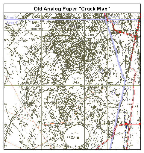
| THE MOVIE MAP: This animated map shows the surface effects produced by multi-year nuclear testing in the vicinity of the Latir detonation at site U-4d. The sequence of maps demonstrates one of the many uses for the digital surface effects maps archive. | |
|
|
Explanation: The "movie map"
loops through a sequence of seven maps. The first map is a scanned, digital
copy of the original composite "crack
map" of this portion of Yucca Flat. This is followed by four
scanned, digital copies of the original (mylar)
maps for sites U-4d (2/27/74), U-4e (2/28/75), U-4a (3/17/76), and U-4L
(2/8/79). The four mylar maps illustrate, in
color, the chronology of mapped surface
effects for the four tests conducted Feb 1974 to Feb 1979. The last two maps are:
(1) a composite GIS surface effects map that was made as a new version
of the Old Analog Paper "Crack Map" and (2) an individual
GIS surface
effects map that was constructed for the Latir detonation at borehole U-4d
from the digital map data contained in archive. The final map in the sequence illustrates how the GIS surface effects map archive can be used to retrieve surface effects and detonation information for a test or group of tests at the NTS. The user can therefore construct a map showing a particular moment in time, as was done for the Latir detonation, from the complex pattern of surface effects seen in a composite map of the area. This is clearly not possible using the Old Analog Paper "Crack Map" in the first frame of this animation. Movie Note: The maps are displayed at different time-delay rates for emphasis. A pause is seen after the first map, after the sequence of mylars, and after the two GIS maps so that these maps can be more easily viewed. |