Metadata also available as: OUTLINE - TEXT
Poppe, Lawrence J. , 2003, ARMSTRONG74: Sediment Data from Great Bay Estuary, New Hampshire: U. S. Geological Survey, Coastal and Marine Geology Program, Woods Hole Field Center, Woods Hole, MA.This is part of the following larger work.Online Links:
- <http://pubs.usgs.gov/of/2003/of03-001/data/seddata/armstrong74/armstrong74.zip>
- <http://pubs.usgs.gov/of/2003/of03-001/data/seddata/armstrong74/armstrong74.zip>
Poppe, L.J., Paskevich, V.F., Williams, S.J., Hastings, M.E., Kelley, J.T., Belknap, D.F., Ward, L.G., FitzGerald, D.M., and Larsen, P.F., 2003, Surficial Sediment Data from the Gulf of Maine, Georges Bank, and vicinity: a GIS Compilation: Open-File Report 03-001, U. S. Geological Survey, Coastal and Marine Geology Program, Woods Hole Field Center, Woods Hole, MA.Online Links:
This is a Vector data set. It contains the following vector data types (SDTS terminology):
Horizontal positions are specified in geographic coordinates, that is, latitude and longitude. Latitudes are given to the nearest 0.00001. Longitudes are given to the nearest 0.00001. Latitude and longitude values are specified in Decimal degrees.
The horizontal datum used is North American Datum of 1927.
The ellipsoid used is Clarke 1866.
The semi-major axis of the ellipsoid used is 6378206.400000.
The flattening of the ellipsoid used is 1/294.978698.
Sequential unique whole numbers that are automatically generated.
Coordinates defining the features.
| Range of values | |
|---|---|
| Minimum: | 1 |
| Maximum: | 81 |
| Units: | stations |
| Resolution: | 1 |
| Value | Definition |
|---|---|
| ARMSTRONG1974 |
| Range of values | |
|---|---|
| Minimum: | 43.04833 |
| Maximum: | 43.18958 |
| Units: | decimal degrees |
| Resolution: | 0.00001 |
| Range of values | |
|---|---|
| Minimum: | -70.92083 |
| Maximum: | -70.81083 |
| Units: | decimal degrees |
| Resolution: | 0.00001 |
| Range of values | |
|---|---|
| Minimum: | 1.2 |
| Maximum: | 84.3 |
| Units: | percent |
| Resolution: | 0.1 |
| Range of values | |
|---|---|
| Minimum: | 0.4 |
| Maximum: | 35.4 |
| Units: | percent |
| Resolution: | 0.1 |
| Range of values | |
|---|---|
| Minimum: | 1.3 |
| Maximum: | 39.7 |
| Units: | percent |
| Resolution: | 0.1 |
Verbal descriptions of the sediment
Please view the cross reference information for the original data set credit to Armstrong (1974). Steve Jones (UNH) for entering the data from the source report, and Larry Poppe for creating the ArcView shapefile.
Lawrence J. Poppe
U.S. Geological Survey
Geologist
384 Woods Hole Road
Woods Hole, MA 02543-1598
USA
508-548-8700 x2314 (voice)
508-457-2310 (FAX)
[email protected]
The purpose of this data layer is to release a digital version of the data published in Armstrong (1974).
Armstrong, P., 1974, Copper, zinc, chromium, lead, and cadmium in the unconsolidated sediments of Great bay Estuary, New Hampshire: Master's Thesis 85 p., University of New Hampshire, Durham, NH.
Person who carried out this activity:
Lawrence J. PoppeData sources used in this process:
U.S. Geological Survey
Geologist
384 Woods Hole Road
Woods Hole, MA 02543-1598
USA
508-548-8700 x2314 (voice)
508-457-2310 (FAX)
[email protected]
Data sources produced in this process:
All attributes were checked by the compilers in a consistent manner.
Navigational accuracy is unknown.
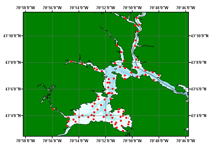
Identifiers, navigation, and grain-size data are provided for 75 stations.
No additional checks for topological consistency were performed on the data
Are there legal restrictions on access or use of the data?
- Access_Constraints: None
- Use_Constraints: None
Lawrence J. Poppe
U.S. Geological Survey
Geologist
384 Woods Hole Road
Woods Hole, MA 02543-1598
USA
508-548-8700 x2314 (voice)
508-457-2310 (FAX)
[email protected]
Regional Mapping of Surficial Sediments: Gulf of Maine and Georges Bank, Aggregates and Habitats Projects, armstrong74.shp
Although this data set has been used by the U.S. Geological Survey, no warranty, expressed or implied, is made by the USGS as to the accuracy of the data and/or related materials. The act of distribution shall not constitute any such warranty, and no responsibility is assumed by the USGS in the use of these data or related materials.
| Data format: | Five files (armstrong74.shp, armstrong74.dbf, armstrong74.shx, armstrong74.sbx, armstrong74.sbn) comprising the ArcView point shapefile components, 'prj' and 'avl' files, metadata text file and browse graphic. in format ArcView shapefile (version 3.2) ESRI point shapefile Size: 0.132 |
|---|---|
| Media you can order: |
CD-ROM
(Density 650
Mbytes)
Note: The user must have a computer system with a CD-ROM available. To browse the information contained on this CD-ROM, the user must have a current WWW browser available. The user must also have software installed on their computer to unzip the archived file.
|
The data is available in ArcView shapefile format. The user must have ArcView 3.0 or greater software to read and process the data file. In lieu of ArcView, the user may utilize another GIS application package capable of importing data.
Lawrence J. Poppe
U.S. Geological Survey
Geologist
384 Woods Hole Road
Woods Hole, MA 02543-1598
USA
508-548-8700 x2314 (voice)
508-457-2310 (FAX)
[email protected]