U.S. Geological Survey Open-File Report 03-041
Figure 10B
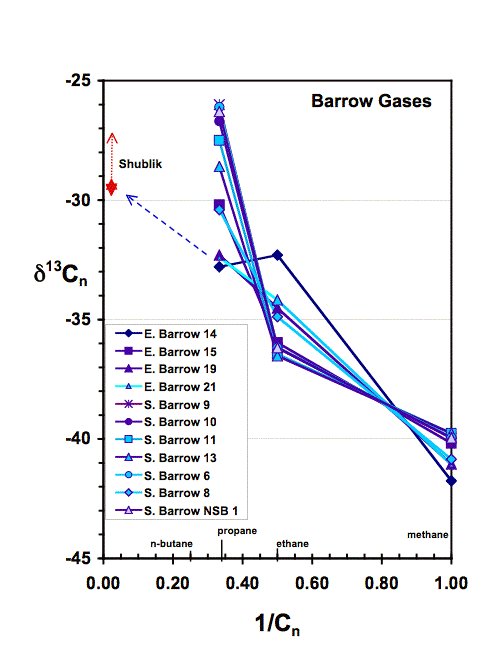
Figure 10. The natural gas plot (Chung, Gormly, and Squires, 1988) showing the carbon isotopic composition of individual hydrocarbons as a function of the carbon number (Cn) of the hydrocarbon. Gases from Walakpa, Wolf Creek, and Umiat fields and one laboratory generated gas from the Hue Shale (see Figure 10E) are shown in 10A. Ranges of the carbon isotopic composition of kerogen from the Shublik Formation, Kingak Shale, Torok Formation shales, and the Pebble shale unit are shown adjacent to the y-axis. Data are from (Burwood, Cole, and others, 1985; Schoell, Wehner, and Coleman, 1985) . Figure 10B shows gases from the South Barrow and East Barrow fields. Gases from the greater Prudhoe Bay area are shown in figure 10C. Additional gases from the greater Prudhoe Bay area and the adjacent fields on the western edge of the greater Kuparuk River field (Masterson, 2001) are shown in 10D. Gases generated in the laboratory during hydrous pyrolysis of North Slope source rocks are shown in Figure 10E. See text for discussion.
[an error occurred while processing this directive]