![]()
![]()
New Jersey Aeromagnetic Index Map and Data Table
![]()
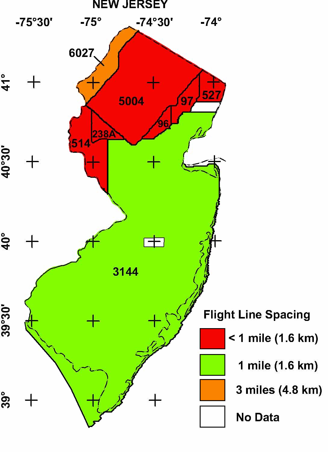
The New Jersey aeromagnetic compilation map contains data from eight separate aeromagnetic surveys and digitized maps. This map is an index to the flight line spacing and altitude of the original surveys. The tabular index below provides a summary of the data sources. References are listed in the bibliography. Selected digital data are available from the National Geophysical Data Center (NGDC), Boulder, Colorado. Files of digitized analog surveys may be downloaded from the USGS site: http://pubs.usgs.gov/of/1999/ofr-99-0557/html/mag_home.htm. Digital flight line data for the USGS survey #3144 is available from the USGS site: http://pubs.usgs.gov/of/2002/ofr-02-361/.
Table of New Jersey Aeromagnetic Surveys
|
|
|
|
|
|
|
|
|
|
|---|---|---|---|---|---|---|---|---|
| 0096 | M-A | New Jersey Highlands '50 | USGS | 10/50-11/50 | 0.25 mi. | N-S | 500 ft AG | GP-171, 173, 174 |
| 0097 | M-A | New Jersey Highlands '51 | USGS | 04/51-05/51 | 0.25 mi. | N-S | 500 ft AG | GP-168, 172, 175, 344, 345 |
| 0238A | M-A | New Jersey Highlands '55 | USGS | 10/55-11/55 | 0.25 mi. | N-S | 500 ft AG | GP-347, 349, 350 |
| 02571 | M-A | Pennsylvania Triassic '56 | USGS | 10/56-12/56 | 0.25 mi. | N-S | 500 ft AG | GP-235, 236 |
| 0514 | M/R-A | New Jersey Highlands '63 | USGS | 08/63 | 0.5 mi. | N-S | 500 ft AG | GP-549-554 |
| 0527 | M-A | Lamont | USGS | 12/63 | 0.5 mi. | E-W | 500 ft AG | GP-492-495 |
| 3144 | M/R-D | Delaware-New Jersey | LKB | 11/78-01/79 | 1 mi. | E-W | 500 ft AG | OF 79-1683 |
| 5004 | M/R-D | Reading Prong | LKB | 09/78-10/78 | 0.25 mi. | NW-SE | 400 ft AG | GJBX-090(80) |
| 6027 | M/R-D | Thorpe Area East | LKB | 11/76-04/77 | 3 mi. | E-W | 400 ft AG | GJBX-016(78), 32(78) |
1 Survey number 0257 partly overlaps small areas in survey 0514. The area covered by project 0257 is too small to be shown on the above index map.
Description of Table:
Survey No.: Internal USGS identification
number
Survey Type: M = magnetics; R = radiometrics; D = digital data; A =
digitized analog data
Survey Name: Internal project name (not always the name used in
publication title)
Flown By: Company or government agency who flew the original survey
Spacing and Dir.: Primary flight-line spacing and primary
flight-line direction
Altitude: Primary flight altitude in feet; AG = above ground draped
over topography
Publication: Brief publication reference. USGS publications are
listed as: Open-File reports = OF xx-yyyy where xx is the publication year
and yyyy is the publication number, Geophysical Maps = GP-yyyy.
NURE publications are listed as GJBX*.
|
|
|