Skip past header information USGS Logo with link to USGS web page
Coastal Vulnerability Assessment of GUIS, USGS Open-File Report 03-108


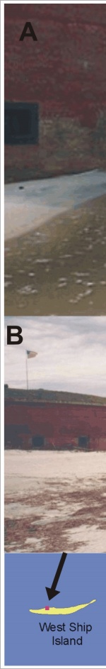
Figure 12.

A) Ft. Massachusetts in 2001 before renourishment.

B) Ft. Massachusetts in fall 2003 following beach renourishment in the spring (photos provided by Linda York).


Figure 12:  A) Ft. Massachusetts in 2001 before the 2002 renourishment.  B) Ft. Massachusetts in fall 2002 following beach renourishment in the spring (photos provided by Linda York). Figure 12:  A) Ft. Massachusetts in 2001 before the 2002 renourishment.  B) Ft. Massachusetts in fall 2002 following beach renourishment in the spring (photos provided by Linda York). Figure 12:  A) Ft. Massachusetts in 2001 before the 2002 renourishment.  B) Ft. Massachusetts in fall 2002 following beach renourishment in the spring (photos provided by Linda York). Figure 12:  A) Ft. Massachusetts in 2001 before the 2002 renourishment.  B) Ft. Massachusetts in fall 2002 following beach renourishment in the spring (photos provided by Linda York).

Skip Footer Information
Department of Interior
 /  U.S. Geological Survey  /  Coastal and Marine Geology / 

USGS Privacy Statement  /  Disclaimer  /  Accessibility
This is http://pubs.usgs.gov/pubs/of/2003/of03-108/html/fig12.html
Maintained by Eastern Publications Group
Modified Saturday, 12-Jan-2013 23:45:01 EST