Cross, VeeAnn A. , 2004, CAPE_GEOLGEOG: Digital Cape Cod and the Islands Geologic Map:.This is part of the following larger work.Online Links:
Hallett, B.W., Paskevich, V.F., Poppe, L.J., Brand, S.G., and Blackwood, D.S., 2004, A Pictorial Survey of the Bedrock Beneath Western Cape Cod, Massachusetts: Open-File Report 03-001, U.S. Geological Survey, Coastal and Marine Geology Program, Woods Hole Science Center, Woods Hole, MA.Online Links:
This is a Vector data set. It contains the following vector data types (SDTS terminology):
Horizontal positions are specified in geographic coordinates, that is, latitude and longitude. Latitudes are given to the nearest 0.000000. Longitudes are given to the nearest 0.000000. Latitude and longitude values are specified in Decimal degrees.
The horizontal datum used is North American Datum of 1983.
The ellipsoid used is Geodetic Reference System 80.
The semi-major axis of the ellipsoid used is 6378137.000000.
The flattening of the ellipsoid used is 1/298.257222.
Sequential unique whole numbers that are automatically generated.
Coordinates defining the features.
character data set
character data set
VeeAnn A. Cross
U.S. Geological Survey
Marine Geologist
384 Woods Hole Rd.
Woods Hole, MA 02543-1598
(508) 548-8700 x2251 (voice)
(508) 457-2310 (FAX)
vatnipp@usgs.gov
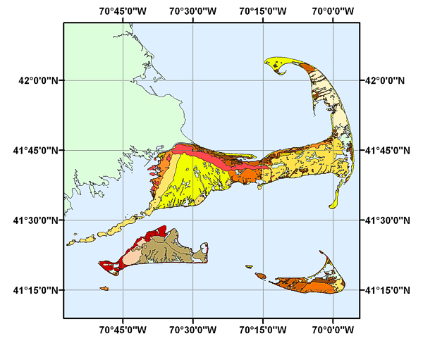
This shapefile is provided as a digital representation of the original paper geologic map: Geologic map of Cape Cod and the Islands, Massachusetts. See source contribution for detailed citation.
Oldale, Robert N. , and Barlow, Roger A. , 1986, Geologic map of Cape Cod and the Islands, Massachusetts: Miscellaneous Investigations Series Map I-1763, U.S. Geological Survey, Reston, VA.
Person who carried out this activity:
Dave Foster
U.S. Geological Survey
Geologist
384 Woods Hole Rd.
Woods Hole, MA 02543-1598
USA
(508) 548-8700 x2271 (voice)
(508) 457-2310 (FAX)
dfoster@usgs.gov
Person who carried out this activity:
Dave Foster
U.S. Geological Survey
Geologist
384 Woods Hole Rd.
Woods Hole, MA 02543-1598
USA
(508) 548-8700 x2271 (voice)
(508) 457-2310 (FAX)
dfoster@usgs.gov
Person who carried out this activity:
Dave Foster
U.S. Geological Survey
Geologist
384 Woods Hole Rd.
Woods Hole, MA 02543-1598
USA
(508) 548-8700 x2271 (voice)
(508) 457-2310 (FAX)
dfoster@usgs.gov
Person who carried out this activity:
VeeAnn A. Cross
U.S. Geological Survey
Marine Geologist
384 Woods Hole Rd.
Woods Hole, MA 02543-1598
USA
(508) 548-8700 x2251 (voice)
(508) 457-2310 (FAX)
vatnipp@usgs.gov
Person who carried out this activity:
VeeAnn A. Cross
U.S. Geological Survey
Marine Geologist
384 Woods Hole Rd.
Woods Hole, MA 02543-1598
USA
(508) 548-8700 x2251 (voice)
(508) 457-2310 (FAX)
vatnipp@usgs.gov
Person who carried out this activity:
VeeAnn A. Cross
U.S. Geological Survey
Marine Geologist
384 Woods Hole Road
Woods Hole, MA 02543-1598
USA
(508) 548-8700 x2251 (voice)
(508) 457-2310 (FAX)
vatnipp@usgs.gov
Person who carried out this activity:
VeeAnn A. Cross
U.S. Geological Survey
Marine Geologist
384 Woods Hole Road
Woods Hole, MA 02543-1598
USA
(508) 548-8700 x2251 (voice)
(508) 457-2310 (FAX)
vatnipp@usgs.gov
Person who carried out this activity:
VeeAnn A. Cross
U.S. Geological Survey
Marine Geologist
384 Woods Hole Road
Woods Hole, MA 02543-1598
USA
(508) 548-8700 x2251 (voice)
(508) 457-2310 (FAX)
vatnipp@usgs.gov
Person who carried out this activity:
VeeAnn A. Cross
U.S. Geological Survey
Marine Geologist
384 Woods Hole Road
Woods Hole, MA 02543-1598
USA
(508) 548-8700 x2251 (voice)
(508) 457-2310 (FAX)
vatnipp@usgs.gov
Person who carried out this activity:
VeeAnn A. Cross
U.S. Geological Survey
Marine Geologist
384 Woods Hole Road
Woods Hole, MA 02543-1598
USA
(508) 548-8700 x2251 (voice)
(508) 457-2310 (FAX)
vatnipp@usgs.gov
Person who carried out this activity:
VeeAnn A. CrossData sources produced in this process:
U.S. Geological Survey
Marine Geologist
384 Woods Hole Road
Woods Hole, MA 02543-1598
USA
(508) 548-8700 x2251 (voice)
(508) 457-2310 (FAX)
vatnipp@usgs.gov
Oldale, Robert N. , and Barlow, Roger A. , 1986, Geologic Map of Cape Cod and the Islands, Massachusetts: Miscellaneous Investigations Series Map I-1763, U.S. Geological Survey.
No additional checks for topological consistency were performed on the data.
Are there legal restrictions on access or use of the data?
- Access_Constraints: None.
- Use_Constraints:
- Public domain data from the U.S. government are freely redistributable with proper metadata and source attribution.
Please recognize the U.S. Geological Survey (USGS) as the source of this information. Please cite the source map as: Geologic Map of Cape Cod and the Islands, Massachusetts, 1986, Robert N. Oldale, Roger A. Barlow: Miscellaneous Investigations Series, Map I-1763.
VeeAnn A. Cross
U.S. Geological Survey
Marine Geologist
384 Woods Hole Rd.
Woods Hole, MA 02543-1598
USA
(508) 548-8700 x2251 (voice)
(508) 457-2310 (FAX)
vatnipp@usgs.gov
Downloadable Data: cape_geolgeo.shp
Although this data set has been used by the U.S. Geological Survey (USGS), no warranty, expressed or implied, is made by the USGS as to the accuracy of the data and/or related materials. The act of distribution shall not constitute any such warranty, and no responsibility is assumed by the USGS in the use of these data or related materials.
| Data format: | Size: 1.266 |
|---|
The data are available in Environmental Systems Research Institute (ESRI) shapefile format. The user must have ArcGIS® or ArcView® 3.0 or greater software to read and process the data file. In lieu of ArcView, the user may utilize another GIS application package capable of importing data. A free viewer, ArcExplorer, is also available from the ESRI website at www.esri.com/software/arcexplorer/download4.html.
VeeAnn A. Cross
U.S. Geological Survey
Marine Geologist
384 Woods Hole Rd.
Woods Hole, MA 02543-1598
USA
(508) 548-8700 x2251 (voice)
(508) 457-2310 (FAX)
vatnipp@usgs.gov