
|
This data set consists of nine files of geochemical information on various types of surficial deposits in northwestern Wisconsin and immediately adjacent parts of Michigan and Minnesota. The files are presented in two formats: as dbase files in dbaseIV form and Microsoft Excel form. The data present multi-element chemical analyses of soils, stream sediments, and lake sediments. Latitude and longitude values are provided in each file so that the dbf files can be readily imported to GIS applications. Metadata files are provided in outline form, question and answer form and text form. The metadata includes information on procedures for sample collection, sample preparation, and chemical analyses including sensitivity and precision. |
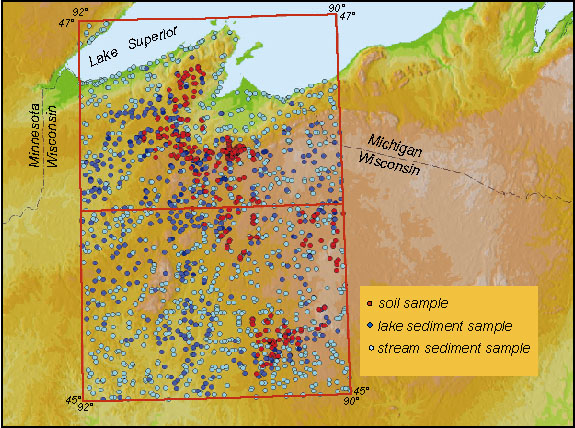 |
| Location of study area and distribution of soil, stream sediment and lake sediment samples. |
|
EXCEL FILES
|
DESCRIPTION
|
DBF FILES
|
|
326 multi-element chemical analyses of A-horizon soils
|
||
|
44 multi-element chemical analyses of B-horizon soils
|
||
|
455 multi-element chemical analyses of C-horizon soils
|
||
|
35 multi-element chemical analyses of E-horizon soils
|
||
|
361 multi-element analyses of lake-bottom sediments
|
||
|
913 multi-element chemical analyses of stream sediments
|
||
|
400 multi-element chemical analyses of stream sediments
|
||
|
913 recalculated chemical analyses of stream sediments
|
||
|
96 multi-element analyses of lake-bottom sediments
|
|
FILES
|
DESCRIPTION
|
|
Metadata in the frequently asked questions format.
|
|
|
Metadata in the standard html format.
|
|
|
Metadata in text format.
|
For questions, please contact William F. Cannon or Laurel G. Woodruff.